Curated OER
South America and Central America Map Quiz
In this online interactive geography quiz worksheet, students examine the map that includes all of Central and South America's countries. Students match each of the country names to the appropriate locations on the map.
Curated OER
South America and Central America Capitals Map Quiz
In this online interactive geography quiz worksheet, learners examine the map that includes all of Central and South America's countries. Students match each of the country names to the appropriate locations on the map.
Curated OER
Dangerous Air
Students investigate how pollution is a global issue. They locate the countries affected by radiation from Chernobyl, sequence the progress of radiation transport from Chernobyl and plot the pollution points on a world map, and read and...
Curated OER
Check My Writing: Diversity of Learners Adaptation
Young scholars explore different spellings of the same words within the English language, as well as different words for the same thing with the international pen pal classroom. They become familiar with units of measure and time. ...
Curated OER
The Caspian Sea
In this comprehension and geography worksheet, learners read an article about the Caspian Sea, identifying where it is located and what countries surround it. Then they describe three parts of the sea, what are tributaries, and how many...
Curated OER
Middle East Related
Eighth graders find a current event related to the Middle East. In this current event lesson plan students write a brief summary of a new story related to the Middle East. They give their opinion and tell how it affects their life or who...
Curated OER
Australia and Oceania Map Quiz
For this online interactive geography quiz worksheet, students examine the map that includes 23 countries, territories, and dependencies of Oceania. Students match the names of each to the appropriate...
Curated OER
Students as Consumers: The Relationships Between Communities
Students survey the clothing they are wearing to determine where it was made. They work in groups to locate the countries where the clothing was manufactured, develop questions about what makes a good purchase and work with a buddy class...
Curated OER
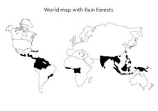
World Map With Rain Forests
In this geography worksheet, students study a map of the world which shows shaded areas indicating where the rain forests are located. There are no labels for countries or continents.
Royal Canadian Legion
Teachers' Guide: Take Time to Remember
The Royal Canadian Legion offers this teacher's guide designed to remind learners of all ages of the sacrifices made by Canadian soldiers in not only World War I but also the Korean and Gulf wars. The 42-page packet is filled with...
Curated OER
Island Countries
Students define the meaning of an island. In this island mapping lesson, students identify islands on the map. Students discuss the sizes of various islands.
Curated OER
Differences in Location Lesson Plan: Treatment of Early African Americans
Students reach The Domestic Slave Trade, then examine the differences between the people enslaved in North America as opposed to those in Brazil.
Curated OER
Lewis and Clark In Columbia River Country Native Foods
Students complete an online activity by following a series of prompts to determine seasonal foods that could be found in the Columbia basin during the Lewis and Clark expedition. They draw a seasonal round that shows a colorful...
Curated OER
Introduction to the United States Map
Learners identify a map of the United States. In this United States map lesson, students study a map of the United States and find various locations on the map. Learners then locate and list the state that touches their state.
Curated OER
Introduction to the United States Map
Students explore the United States using a map. In this map instructional activity, students discover how to use a United States map and a globe to locate places.
Curated OER
Labeling the World
Sixth graders conduct research on the countries found on the labels on their clothing. They locate the countries on a map, research the labor practices on countries that export clothing to the U.S., and create a graph using the information.
Curated OER
Social Studies: World Cultures and the Library of Congress
Students use the Library of Congress Website to locate information for a world cultures project. They select countries to research, investigate visa information, currency, climate, and accommodations. Students follow the directions on...
Curated OER
United States Map Lesson
Students explore basic map skills. In this United States geography lesson, students define "country" and "state," locate their state on a United States map, and identify and trace state boundaries defining their state and surrounding...
Curated OER
Eastern Europe: Passport to Understanding
Seventh graders explore Eastern Europe. They analyze data on select countries. Students prepare a short oral presentation on the country they researched. They locate their country using an interactive map.
Curated OER
Shopping for Souvenirs In the Middle East
Students participate in a role play in which they are shopping for souvenirs in the Middle East. Using maps, they locate the Middle East and identify each country within the region. They create a key map for the types of souvenirs that...
Curated OER
United States Map - Lesson 4: States
Students use a United States Map to locate their state and use map symbols to determine the boundaries of a state. In this states lesson plan, students learn the definition of a state and identify their own on a map.
Curated OER
Cultures Around the World
Students research, using the Internet, cultures of the world. They identify countries, their currency, holidays, climate and societal information. They look at the distance of international cities from their hometown.
Curated OER
Map Skills: Explorers, Continents, and Oceans
Third graders use a software program to make and label a map of the world. On the map, they locate the seven continents, oceans and the countries of Europe. They also draw the routes of Christopher Columbus, Juan Ponce de Leon and...
Curated OER
African life VS American life: Food and 3rd World and 1st World counties
Third graders explore the difference in 3rd world and 1st world countries. In this social studies lesson, 3rd graders are divided into groups and given varying amounts of food. Students discuss the unfair distribution of the food....


