Curated OER
Where Are We?
Students use Cartesian coordinates or degrees of latitude and longitude to locate important locations within their specific countries. They Use a grid to apply the concept of latitude and longitude, or positive and negative Cartesian...
Curated OER
Activity on United States Moon Landing: Apollo 11
Young scholars use the World Wide Web to access additional information needed to complete a set of questions. They demonstrate an understanding of latitude and longitude by interpreting a lunar map.
Curated OER
Plate Patterns
Students read about a volcano and use the latitude and longitude information to plot and describe the volcano on the map. They discuss patterns seen on the map. In addition, they color code a map according to zones, plates, etc.
Curated OER
Map Coordinate Bingo
Students play a bingo-type game to locate cities by coordinates. They explain the use of orientation on a map and identify cities in the western hemisphere. They compare road maps, shutttle images, and a CIR image and obtain an...
Curated OER
The Pilgrims
Students use distance measuring tools to follow directions and chart the path the pilgrims made from Plymouth, England to Boston, Massachusetts. In this Pilgrim voyage lesson, students use a map to chart the distance traveled by the...
Curated OER
Science: Hurricanes As Heat Engines
Pupils conduct Internet research to track the path of Hurricane Rita. They record the sea surface temperature of the Gulf of Mexico during and after the hurricane and draw conclusions about how hurricanes extract heat energy from the...
Midnight Martian
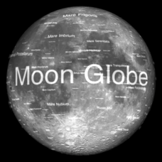
Moon Globe
Not just a simple globe of the moon, this interactive version allows you to choose lighting according to the location of the sun, views from different positions on Earth, and more! Satellite images and topographic data have been combined...
Curated OER
Earthquake Depth
Students research and locate earthquake epicenters on a map using latitude and longitude. They determine if the depth of an earthquake has any relationship to the distance from a plate boundary.
Curated OER
Globe Skills Lesson 8 Dust Bowl Travelers
Students develop their globe and map skills, In this geography lesson, students examine the Dust Bowl as they complete an activity that requires them to plot latitude and longitude.
Curated OER
GPS Scavenger Hunt
Learners go on a GPS scavenger hunt. They use GPS receivers to find designated waypoints and report back on what they found. They compute distances between waypoints based on the latitude and longitude, and compare with the distance the...
Curated OER
Factors That Affect Climate
Fifth graders use captured portions of the Internet ("mininets") to perform research into climate. They create graphs of the data recorded using latitude as the independent variable and temperature as the dependent variable.
Curated OER
Linkages Between Surface Temperature And Tropospheric Ozone
Students collect and interpret data to make predictions about the levels of ozone in the atmosphere. Using the internet to collect data students use their collected data to create a line graph for analysis. Students make mathematical...
Curated OER
Charles Lindberghs's Flight to Paris
Students practice map skills. In this map skills lesson, students locate the cities of New York and Paris on a map. Students read about the flight made by Charles Lindbergh in May 1927 from New York to Paris. Students answer 8 questions...
Curated OER
Map of Arctic Region
In this Arctic region geography worksheet, students examine a map of the Arctic and color it. The latitude and longitude lines are shown as well as the labeled countries and oceans. The map shows an overhead view looking down on the...
Curated OER
Students Become Mapmakers
Learners practice making a map of a continent and correctly plotting five cities on that map. They place latitude and longitude lines on a map, determine the need for various map projections and explain why map scales are necessary.
Curated OER
The Librarian Who Measured the Circumference of the Earth
Sixth graders explore angles, triangles, and investigate the circumference of the earth. They participate in a Webquest, access data bases, and communicate with other students through an on-line project site involving the circumference...
Curated OER
Sunrise and Sunset - Graph of Daily Solar Radiation
Students use a graph of daily solar radiation to determine the times of sunrise and sunset. They also compare how sunrise, sunset, and the length of the day changes with latitude and longitude.
Curated OER
A Bird's Eye View of our 50 States
Third graders focus on state birds as they learned absolute location (latitude/longitude) of each state, as well as their relative location (bordering states).
Curated OER
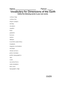
Vocabulary for Dimensions of the Earth
In this Earth dimensions worksheet, students define 24 terms associated with contour maps, latitude, longitude, and time zones.
Curated OER
Westward Expansion
Students locate California and New York on a map and explore available means of travel in the 19th century. Students explore the role of trade in pioneer America and simulate various barter transactions.
Curated OER
Are We Falling Apart? Exploding Volcanoes
Students research and demonstrate volcanic activity. In this volcanism lesson, students research the types of volcanoes and define related terms using the Internet. They demonstrate volcanic activity with water, corn syrup, and flour.
Curated OER
Broken-Heart Matching Game
Students use this fun game to practice, reinforce, or apply a wide variety of skills around Valentine's Day. Each students receives half a heart with zig-zag cuts made of pink construction paper with a piece of information. Their job is...
Curated OER
The Solstices
Compare surface temperatures when the solstice occurs in the different hemispheres. Young scientists draw conclusions from their investigation of data collected using spreadsheets and a globe.
Curated OER
Water Monitoring Vocabulary
As the title implies, this is a list of vocabulary terms relating to water monitoring. If your ecology class is learning about how to test water quality, this will be an appropriate reference sheet for them. As a bonus, if you live in...


