Curated OER
Early Explorers
Students answer short answer questions and participate in a role play where they are explorers being interviewed. In this early explorers lesson plan, students discuss why it is beneficial to be the first one in a place.
Curated OER
The Five Themes of Geography
In this geography skills instructional activity, students respond to 18 fill in the blank and short answer questions about the 5 geography themes.
Curated OER
CLIL: A Lesson Plan
Students explore Vancouver. In this Vancouver geography and English language building lesson plan, students brainstorm what they know about Vancouver and predict what their text will cover. Students listen to the informational content of...
Curated OER
Creating and Analyzing Graphs of Tropospheric Ozone
Students create and analyze graphs using archived atmospheric data to compare the ozone levels of selected regions around the world.
Curated OER
Three D Constellations
Students are introduced to both celestial coordinates and to the first rung on the distance determination ladder. They convert spherical coordinates to Cartesian coordinates to construct a three dimensional model of a constellation...
Curated OER
A Geopoem About Alaska
Sixth graders conduct Internet research on the physical and human characteristics of Alaska. They compose and write geopoems about the state of Alaska, using a template.
Curated OER
Hurricanes
Eighth graders gather information on hurricanes that are affecting the world at the time of the lesson. They work together in groups to collect the data and record their information in a table. They are asked questions to finish the lesson.
Curated OER
Underwater Picture of the Hudson River Estuary
Students identify important aspects of water quality such as slainity and turbidity. They test two of the water quality parameters and determine the quality of the water. In addition, they construct two sets of graphs based on data...
Curated OER
On the Road Again": Moving People, Products, and Ideas
In this lesson students learn how to identify modes of transportation and communication for moving people, products, and ideas from place to place. Students also study the advantages and disadvantages of different modes of...
Curated OER
Vocabulary Review: Completing Sentences
In this vocabulary worksheet, students check the word that will correctly complete a sentence, 7 sentences. Students choose from 4 words.
Curated OER
Natural Hazards
Students evaluate the hazards of naturally occurring events. After watching a video concerning safety hazards, students work in groups to discuss the safety issues involved in taking a trip to a mountainous region. Recommendations are...
Curated OER
Interpreting Satellite Images
Students identify differences between photography and satellite imagery space.
Curated OER
Subsidence/ Erosion
Students utilize prior knowledge about the Pontchartrain Basin. In this subsidence/erosion lesson, students study the chart on land subsidence and must them identify and find solution for problems caused by erosion.
Curated OER
Circle the Earth - Explore Surface Types on a Journey around Earth
Students use CERES percent coverage surface data with a world map in locating landmasses and bodies of water at Earth's Equator.
Curated OER
Linkages Between Surface Temperature And Tropospheric Ozone
Pupils organize and analyze data regarding changes in tropospheric ozone and then hypothesize about the consequences of these changes.
Curated OER
Chuuk Introduction (Middle School)
Learners pretend they are visiting a relative in the Chuuk nation of Micronesia. Using their knowledge of the 4th of July, they compare and contrast the holiday to the Chuuk's independence day. They create travelogues that outline...
Curated OER
Our Fifty States
Seventh graders identify and locate all fifty states in the United States and their capitals. Individually, they research one state identifying when it became a state, its motto, song, flower and nicknames. To end the instructional...
Curated OER
The Legend of the Indian Paintbrush: Native American Life
Young scholars read," The Legend of the Indian Paintbrush" by Tomie dePaola and discuss the way legends are passed down orally. They then create their own legend and illustrate it on a simulated "Buffalo Skin" made from brown paper.
Curated OER
The Life of Dona Felisa Rincon De Gautier
Students identify Puerto Rico and discuss its relationship and proximity to the United States. Next, students identify significant events that occurred during Dona Felisa's term in office and how if may have affected her popularity. ...
PBS
Pbs Nova: Find Your Longitude
Lost at sea with only your sextant? Use your knowledge of longitude to find your place. The non-shockwave interactive activity makes the concept of longitude concrete.
Social Studies for Kids
Social Studies for Kids: Latitude and Longitude
A collection of latitude and longitude mapping activities ranging from pin-pointing exact locations on the globe to researching the history behind this basic geography concept.
Pamela Seed
The Art and Science of Fifteenth Century Navigation: Latitude
Chronicle of the changes that occurred in various areas when latitude was identified in 1516. Site includes links to the changes in maps, compass roses, and the science of sailing.
National Geographic
National Geographic: A Latitude/longitude Puzzle
Through examining maps students will be able to identify locations and characteristics of them based on latitude and longitude and infer what events might occur in the places.
City University of New York
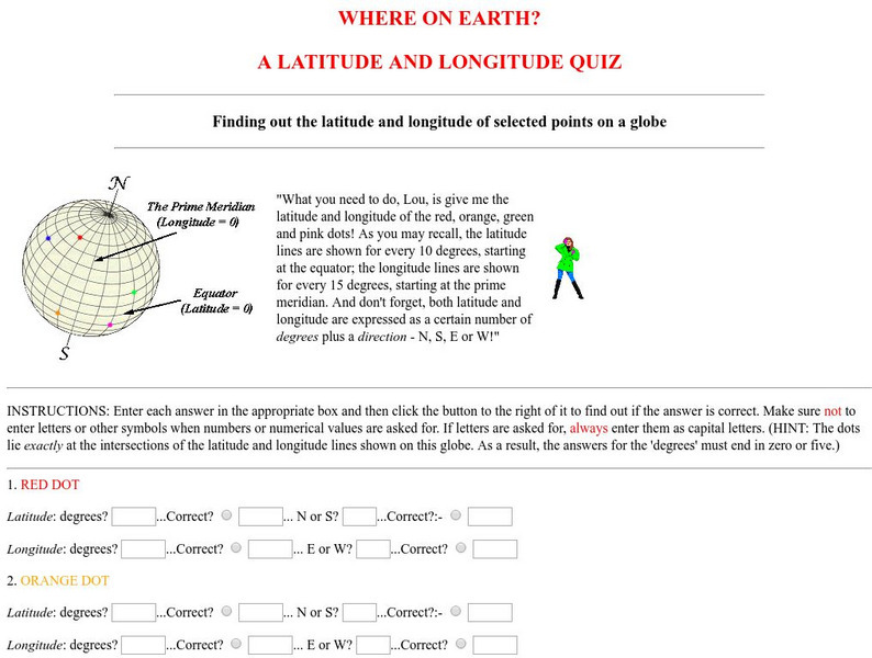
Virtual Geology: Where on Earth: A Latitude and Longitude Quiz
This quiz starts with select points on a globe. Students must determine the latitude, longitude, and direction for each point.
Other popular searches
- Latitude and Longitude Maps
- Maps, Longitude and Latitude
- Maps, Longitude Latitude
- Maps Longitude Latitude
- Maps, Latitude/longitude


