Curated OER
Scaling it Down: Caves Have Maps, Too
Measurement and map skills are the focus of this lesson, where learners crawl through a "cave" made out of boxes, desks and chairs, observing the dimensions. Your young geographers measure various aspects of the cave and practice math...
T. Smith Publishing
Map Skills
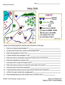
Help younger learners develop their map skills with this simple worksheet, which includes 12 questions utilizing a map legend that involves highway markers, population indicators, and other landmark signs.
Curated OER
Mapmaker, Mapmaker, Make Me a Map
Second and third graders practice with basic map skills. They create their own map including a legend and a compass rose. This fabulous plan has many excellent websites linked which allow learners to explore maps of all kinds; including...
Curated OER
Mapping a Garden
Learners study the components of a map, particularly the legend, the key, the symbols and the area. They develop their own map of a garden that they can plant in a future science lesson.
Curated OER
United States Map- Map Legend/City Symbols
Students investigate the United States map. In this map skills geography lesson plan, students explore city symbols on the map legend and identify them. Students use post-it notes to mark various symbols.
Curated OER
What Do Maps Show?
This teaching packet is for grades five through eight, and it is organized around geographic themes: location, place, relationships, movement, and regions. There are four full lessons that are complete with posters, weblinks, and...
Curated OER
Map Keys
In this geography worksheet, students identify who a cartographer is and what they do specifically. They study an outline map of a fictitious island and then, respond to the three questions that follow. Finally, students add three more...
Curated OER
Topographic Mapping Skills
In this geography instructional activity, learners read an excerpt about topographic maps and why they are useful for various jobs. They also respond to eleven questions that follow related to the excerpt and locating specific map points...
Curated OER
Mapping the News
Young scholars explore cartography. In this map skills and map making lesson, Students work in groups to create wall size world maps including legends, compass roses, latitude and longitude, and physical features. Young scholars...
Curated OER
U.S. Political Map
Students explore the symbols found in a map legend. In this map skills lesson, students locate the legend on a political map and explain what each of the symbols mean. Students locate and identify several symbols on the map.
Curated OER
Countries of the World
Students define the meaning of the word country. In this countries of the world map lesson plan, students identify boundaries, countries, and symbols within countries on the map. Students distinguish the words country and continent.
Institute for Geophysics
Understanding Maps of Earth
Here is your go-to student resource on primary geography concepts, including facts about the surface of the earth and its hemispheres, latitude and longitude, globes, types of maps, and identifying continents and oceans.
Curated OER
Political Legends and Map Symbols
Students identify the legend and map symbols. In this map skills lesson, students use a world map to find various locations using a map key.
Curated OER
United States Map- State Capitals
Young scholars explore map skills. In this state capital lesson, students view a United States Political Map and identify and use post-it notes to label the state capitals.
Curated OER
United States Map
Students describe cities they are familiar with. In this United States Map instructional activity, students understand how cities are listed on a map. Students become aware of a map legend and the information in it.
Curated OER
Where Am I: How to Read a Map
Third graders develop an understanding of maps. They explore what a map is, who uses maps, and how to use maps. Students investigate the compas rose. They create a compose rose which illustrates the cardinal directions. Students practice...
Curated OER
Archaeology- State Map
Students study state maps. In this map skills lesson, students identify the states' location and how to use a legend. Students complete photocopies of the state map.
Curated OER
BOLTSS Map
In this geography instructional activity, students identify the six features always used on maps. They identify each of these features by the acronym BOLTSS. Students examine the Melbourne Cricket Ground shown and respond to the 4...
Curated OER
Map Making/Floor Plans/Map Reading
Students apply their knowledge of scale when mapping the classroom. They determine the use of a map legend and orient a map using a compass. They create the classroom maps using transfer graph paper.
Curated OER
As the Kids Come and Go: Mapping a Classroom
Map the classroom with your kids to help them understand how maps work and how to read them. The lesson starts off with a story about animals living and moving around the globe, and then kids create maps of their classroom to show how...
Curated OER
A Walk Around the School: Mapping Places Near and Far
After reading Pat Hutchins’ Rosie’s Walk, have your young cartographers create a map of Rosie’s walk. Then lead them on a walk around the school. When you return class members sequence the walk by making a list of how the class got from...
Curated OER
Map Adventures
Students explore the relationship between a scale drawing and actual distance. For this mapping lesson, students use an amusement park map to determine distances and what they would be like in real life.
Curated OER
Mapping the Census
Students learn why the census makes a difference. In this U.S. Census lesson plan, students learn the key elements of cartography, examine the difference between data and their representation, and create a map using census data.
Curated OER
Transportation and Mapping
Young scholars view murals that depict various modes of transportation. They discuss the importance of maps to navigation and create a map. They compare and contrast transportation of the past with modes of transportation used today.


