Curated OER
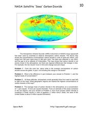
NASA Satellite 'Sees' Carbon Dioxide
In this atmospheric carbon dioxide learning exercise, high schoolers observe a map showing the concentrations of atmospheric carbon dioxide taken by the Atmospheric Infrared Sounder instrument. Students solve 4 problems using the map....
Curated OER
Touring Delmarva
Young scholars plan a trip. For this trip planning lesson, students use a map to find where they would like to visit with a pretend family of 4. They get a specific amount of money and time and need to decide where they will stay and...
Curated OER
States and Capitals, Mountains and Rivers
Students identify geographical locations in the midwestern United States. For this geography lesson, students identify 12 states and capitals and geographical features in the region by using U.S. maps. Students use blank maps to fill in...
Curated OER
Backyard Blitz
Students create a landscape design using shapes, colors and textures. A key is created with hyperlinks to information reports pertaining to the plants, trees and shrubs used in the design. Explore design principal utilizing a variety of...
Curated OER
Treaty Trail: Historical Perspectives Point of View
Students research the point of view of key figures present at the Walla Walla Treaty council. Students analyze primary and secondary sources to determine how various groups of people involved in the treaty council viewed the events as...
Curated OER
The Watershed Quest
Students examine their connection to local watersheds. They describe the water cycle and list species living in their local watershed. They also draw a map of their community.
Curated OER
Sequence Writing: Life Cycles - Plant Life
Students investigate the stages of plant life. Students create a K-W-L chart. They describe six main stages of the plant life cycles. Using stickers, students create a life cycle flow map.
Curated OER
World War I
Students justify how alliances lead to war. They compare the conflicts of war that arose because of imperialist interest. Students explain the cause of World War I. They compare and contrast European maps before and after World War I....
Curated OER
Ocean Currents and Sea Surface Temperature
Students use satellite data to explore sea surface temperature. They explore the relationship between the rotation of the Earth, the path of ocean current and air pressure centers. After studying maps of sea surface temperature and ocean...
Curated OER
Emancipation Proclamation
Students analyze key components of a portrait and relate the elements to the historical context. In this lesson students evaluate the "Emancipation Proclamation" and it's significance.
Curated OER
The Great Migration
Young scholars explore how migration to Harlem created a new life for African Americans. In this cross curricular lesson plan, students illustrate maps showing the migration, paint murals representing African American life in the South...
Curated OER
The Birds and the Beaks
Students explore the adaptations that birds have. In this adaptations lesson students view a video and create a concept map of birds and their adaptive traits.
Curated OER
Civil War and Reconstruction
Students examine the differences between the North and South during the pre-Civil War era. In this Civil War era lesson plan, students spent 7 days looking at things that were different between the Union and Confederate state before the...
Curated OER
Harriman and Plant Identification
Students observe and record botanical details from the plant specimens. They identify plants using sorting key and field guide and classify specimens for preservation and display purposes.
Curated OER
Comparing the New Madrid and San Andreas Fault Zones
In this faults learning exercise, students use an earthquake reference sheet to find the numbers for a modified Mercalli and Richter scale. They compare the San Andreas Fault zone and the New Madrid fault zone on the United States map....
Curated OER
Michigan Food: From Farm to You
Students recognize Michigan on a map and understand how its climate is affected by the Great Lakes. In this Michigan food lesson, students play a trivia game to identify the produce of Michigan. Students relate the climate in each part...
Curated OER
Reading Comprehension
In this reading comprehension lesson, 3rd graders read the story Treasury of Literature and complete various comprehension activities. Students answer factual questions about the story, analyze the story using a bubble map, and extend...
Curated OER
Zimbabwe
In this Zimbabwe learning exercise, students read an article and examine a map of Zimbabwe and then respond to 11 short answer questions regarding the economy and geography of the country.
Curated OER
National Standards Can Be Met With Goal Setting and Tracking
Here are ways to map and meet students' content needs.
Curated OER
A STEP IN SPECIATION
Students place different subspecies of a CA salamander are placed on grid map of CA according to where samples were collected. Then discuss patterns of their distribution, their likely evolutionary relationships, and probable sequence of...
Curated OER
Freedmen's Bureau
Students examine the African American experience after they received their freedom after the Civil War. They complete a Mind Map, read and analyze a poem, and write a paragraph using key vocabulary words. They analyze the impact of the...
Curated OER
Landforms and Resource Regions
In this geographical regions learning exercise, students read a short passage, examine 2 maps which show landforms and regions in South America, then answer 4 comprehension questions based on the information from the maps and the reading...
Curated OER
Vocabulary Bursting with Energy
Students review key physics terms using a Visual Thesaurus. In this science lesson plan, student groups compete against each other to correctly identify "imposter" words from a list of related physics vocabulary terms.
Curated OER
Ancient Greece: Athens as a City State
Sixth graders find Greece on the map and recognize how the geography of Greece was important in its development. In this ancient Greece lesson plan, 6th graders research Greece and compare to the civilization of ancient Egypt. Students...
Other popular searches
- Map Key and Legend
- Map Legends
- Map Key Legend
- Map Keys and Legends
- Map Key Legend Activities
- Map Legends and Symbols
- Map Legends First Grade
- Interpreting Map Legends
- Reading Map Legends
- Creating Map Legends
- Using Map Legends
- Semantic Map Legends


