Curated OER
Revolution! The Atlantic World Reborn
This resource is rich with primary and secondary source material regarding major events in the Atlantic world during the Age of Revolution. While there are suggested classroom activities toward the beginning of the resource, its true...
Curated OER
World Geography - Climate Notes
A challenging activity helps young geographers explore the temperatures around the world! They study how the Earth's land temperatures are affected by their proximity to an ocean, as well their latitude and their altitude. A very...
Curated OER
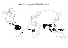
World Map With Rain Forests
In this geography worksheet, students study a map of the world which shows shaded areas indicating where the rain forests are located. There are no labels for countries or continents.
Curated OER
Mapping My World
First graders make two maps. In this developing and reading maps lesson, 1st graders read Mapping Penny's World, discuss the parts of a map, create a map of their classroom, and create a list of directions of how to get to various...
Curated OER
Make a Classroom Map
Students map the items in their classroom to explain the importance of coordinate systems.
Curated OER
Why All Maps Lie
Eighth graders discover the fundamental advantages/disadvantages of both maps and globes. They see that maps may distort size, shape, distance and direction. They discuss the advantages and applications of 5 types of map projections and...
Curated OER
2nd Grade - Act. 21: Me On the Map
Second graders read book, Me On the Map, and create map of their bedroom and of their house.
Curated OER
A Map as a Tool
Young scholars study the concept of using a map as a tool with the usage of a balloon designed to mimic the features of the Earth with the major features marked and shown on the balloon.
Curated OER
Where in the World Is ...
Students locate and place countries and continents on a large map using tag board and yarn. They locate a new geographic location on the map each morning.
Curated OER
Reading the World, Then and Now
Students distinguish geographic features using Ptolemy's map of the world.
Curated OER
Map Skills: Explorers, Continents, and Oceans
Third graders use a software program to make and label a map of the world. On the map, they locate the seven continents, oceans and the countries of Europe. They also draw the routes of Christopher Columbus, Juan Ponce de Leon and...
Curated OER
Survivor Stories
Trace a survivor's story using a timeline, map skills, poetry and/or prose and photography, and make a visual representation of a survivor's journey through his or her life as a culminating activity for the class and the survivor....
Curated OER
But Where Is It On This Modern Map? A problem-solving, mind-boggling experience!
Trace Columbus' voyages by locating them on 21st Century maps. Using a navigators lesson, 4th graders will examine the Age of Exploration and trace Columbus's routes accurately on laminated world maps using different maps. Note:...
Curated OER
Maps
Maps, globes, and computer software aid young explorers as they locate state capitols, major cities, geographic features, and attractions for states they are researching. They then use desktop publishing software to create a map to share...
Curated OER
Our World With MapsQ
Students examine and compare different types of maps. In this map skill instructional activity, students look at neighborhood and national maps on the overhead projector while making comparisons of the symbols and locations. They use a...
Curated OER
Welcome to My World!
Students use maps to locate information. They read the story, "It Looked Like Spilt Milk", view images of the continents and discuss the various continents. Afterward, they make their own Atlas to record information that they can later...
Curated OER
Mapping National and Geographic Identity
Young scholars analyze geographic maps. In this map analysis lesson, students analyze the symbols in geographic maps and the impact of cultural, historical, and political concepts. Young scholars compare and contrast maps in various...
Curated OER
Introduction to World Religions - Hinduism
Sixth graders explore Hinduism. In this world religions activity, 6th graders listen to a lecture about the attributes of the religion and then listen to and perform parts of The Remayana. Students also complete a map activity based on...
Curated OER
World War I
Students justify how alliances lead to war. They compare the conflicts of war that arose because of imperialist interest. Students explain the cause of World War I. They compare and contrast European maps before and after World War I....
Curated OER
MAPPING YOUR NEIGHBORHOOD
Students uses atlases, maps, and Web resources to generate and examine maps of their own neighborhoods. This activity serve as background for the map-reading tasks in the next lessons.
Curated OER
World War I
Eighth graders examine the condition of the world from 1880 until the start of World War I. After watching a PowerPoint presentation, they discuss the causes and effects of the war and complete a study guide with a partner. To end the...
Curated OER
Nazi Concentration Camps -- Map and Chart-Reading Activities
Students use an informational chart about Nazi concentration and death camps to complete a mapping activity and a chart-reading activity.
Curated OER
Using Old Maps as Tools to Explore Our World
Students explore historical maps. In this primary source analysis instructional activity, students uncover the meanings in selected historical maps as they use them to enhance lessons on historical events. Samples for classroom use are...
Curated OER
Fairy Tale Maps
Students study direction as they listen to the stories of Little Red Riding Hood and The Jolly Postman. In this cardinal direction lesson, learners create a map to show the path Little Red Riding Hood took in the story and label the path...
Other popular searches
- World War Ii Map
- World War I Map
- World War 2 Map
- World War I Outline Map
- World Climate Map
- World Biomes Map
- World Outline Map
- Blank Map of the World
- World Political Map
- Ancient World Greece Map
- World Time Zone Map
- Deciduous Forests Map World


