Curated OER
Book: First Encounters Between Spain and the Americas: Two Worlds Meet
Students, after reading Chapter 1 in the book, "First Encounters Between Spain and the Americas: Two Worlds Meet," design and create a map of the Aztec Empire at the time of the first contract with the Spanish. They create the map from...
Curated OER
What is Kwanzaa?
Describe the general characteristics of Kwanzaa after reading Seven Candles of Kwanzaa. For this Kwanzaa lesson, learners study the principles of the Kwanzaa holiday and interpret the principles through music and dance. They...
Curated OER
Middle East Related
Eighth graders find a current event related to the Middle East. In this current event lesson students write a brief summary of a new story related to the Middle East. They give their opinion and tell how it affects their life or who it...
Curated OER
Countries of Africa
Students investigate the different countries of Africa. In this African geography lesson, students choose an African country to investigate and construct the country's flag. Students use a map of Africa to color in their country.
Curated OER
Global Intelligence
Students discuss the war in Afghanistan and the conditions surrounding the hunt for Osama bin Laden after reading the article "Bin Laden and Omar: Far Harder to Find" from The New York Times. After the class discussion, students...
Curated OER
Off to the Future
Students read a handout and predict the position of the San Andreas Fault far in the future. In this future world lesson, students use a map worksheet to demonstrate the path of the Pacific Plate millions of years from now.
Curated OER
The Legacy of the "Great War"
Students study how the map of Europe changed as a result of the Treaty of Versailles at the end of World War I. They examine the results of the end of the Cold War.
Curated OER
Early History of Our Lane
Second graders study Native American Kalapuya culture. In this American History lesson, 2nd graders discover the early inhabitants of their community. They take a field trip to Dorris Ranch.
Curated OER
Dinosaurs In Argentina
Students study the fossils in Argentina and why it is a good place to find them. In this dinosaurs lesson students learn about the recent dinosaur excavations.
Curated OER
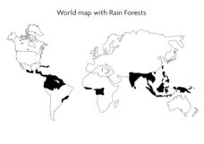
World Map With Rain Forests
In this geography worksheet, students study a map of the world which shows shaded areas indicating where the rain forests are located. There are no labels for countries or continents.
Curated OER
Plate Tectonics: Recycling the Seafloor
Young scholars classify earth's layers and plates using Ocean Seismicity data. In this plate tectonics lesson, students outline where the plate boundaries are on the world map. They then compare these predicted boundaries with USGS map...
Curated OER
Plates on the Move
Students explore how Africa appears to be tearing apart from Asia and tha the other continents are moving and oceans are changing size.
Curated OER
Three Young Pilgrims
Fifth graders study the story of the voyage of the Mayflower told from the view point of the three Allerton siblings who were on board the ship. The book tells of their voyage across the Atlantic and their first year here on the North...
Curated OER
Walking that Line
Students attempt to describe and use longitude and latitude. They will identify different countries, their neighbors, and borders around the world. Included in the lesson the students identify natural features that control the borders of...
Curated OER
Paleogeographic Mapping (o.k. Fossils Are Neat But What Good Are They?)
Students examine how evidence from fossils can be used in paleogeographic interpretation. They gain experience in developing multiple hypotheses.
Alabama Learning Exchange
Coral Reefs
Study explore coral reefs. For this coral reef lesson, 4th graders examine the physical structure of coral reefs. Students consider why coral reefs need to be protected and ways to protect them.
Curated OER
Thematic Unit on Cats
Students discover in which climates the cats of the world live in. They review the different climates of the world and use maps and globes to help them locate continents.
Curated OER
Antarctica
Third graders become familiar with Antarctica, the Earth's southernmost continent, by researching its environment and inhabitants. They reference maps, conduct Internet research, identify animals, create graphs and write reports.
Curated OER
The Great Continental Drift Mystery
Students stud the concept of Pangaea by using Wegener's clues to construct a map of the continents joined together. They determine how fossil distribution can be used to enhance the study of continental drift. They locate the...
Curated OER
Colonization: Africa
Learners analyze maps of Africa. They label physical features, tribal kingdoms, and European settlements, among other topics on the maps. They write reflective paragraphs on their work.
Curated OER
Africa
Students complete various activities related to the continent of Africa. They label and color a map of Africa, sing the Continent Song, view pictures and discuss animals of Africa, listen to the book "Bill and Pete Go Down the Nile,"...
Curated OER
Where in the World is Egypt?
In this geography worksheet, students investigate the location of the continent of Africa and the country of Egypt by studying a map of the region. Students color the map and locate Egypt.
Curated OER
The borders of Europe. Geographically location or cultural artifice?
Twelfth graders discuss where they regard the boundaries of Europe to be. They raise their awareness that "Europe" may be more of a cultural construct than geographical defined continent.
Curated OER
Chocolate Place - Factories around the world
Students create a PowerPoint presentation on how chocolate is made. In this chocolate lesson, students locate chocolate factories around the world, and study the process of converting the cacao seed into a chocolate bar. Students share...


