Curated OER
"The Most Dangerous Game" Study Guide
After reading Richard Connell's best known work, "The Most Dangerous Game," have your class complete the 12 study questions included here. Readers answer plot related questions, compare and contrast characters, and analyze story...
Curated OER
Character Map
A character map worksheeth as this would be handy for your class to support characterization study for any text. It is completely adaptable: your learners choose a character, write three traits in ovals and identify two instances that...
It's About Time
Organizing a Store
When provided with multiple objects, how many ways can the class organize and display them based on predetermined factors? Assist class members with a handy activity—theoretically teaching them concepts to understand periodic...
Curated OER
Map Skills
In this history activity, students use a map and legend to answer nine comprehension questions. Students check their answers when done.
Curated OER
Map Skills
For this history worksheet, students utilize a map and legend to answer eleven comprehension questions. Students check their answers when done.
Curated OER
Topographic Maps Worksheet
In this geography skills worksheet, students respond to 37 multi-part questions that require them to read and interpret topographic maps.
Curated OER
Worksheet for Analysis of a Map
In this primary source analysis activity, students respond to 6 short answer questions that require them to analyze the maps of their choice.
Curated OER
Mapping World War II: During and After
In this World War II worksheet, students follow the provided instructions to mark 2 maps according to events and outcomes of the war.
Curated OER
Map Work: How Far?
In this map scale worksheet, learners analyze a map of an area with several towns marked. Students use the scale (1 cm = 1 km) to answer 6 questions about the distances between towns.
Curated OER
Sub-Saharan Maps
In this geography skills worksheet, students draw real or imaginary maps that feature escarpment, rift valleys, gorges, diamond mines, plateaus, mountains, lakes, rivers, and gold mines.
Curated OER
World War II Map
In this World War II map worksheet, students identify the labeled Axis and Allied countries on the map.
Curated OER
Roman Empire Map
In this Roman Empire worksheet, middle schoolers label the 6 noted areas of the Roman Empire marked on the map.
Ms. Catsos
Ancient Rome Map Worksheet
It wasn't just the great leaders of ancient Rome that shaped their civilization—the geography of the region played a major role as well. After first identifying major land masses, bodies of water, and city states on a map of Europe,...
Curriculum Corner
Camping Literacy Pack
Increase camping vocabulary just in time for summer with a camping themed literacy pack. Use word cards and sentence cards to enhance fluency, build vocabulary, and strengthen writing skills. The activities are perfect for centers,...
Curated OER
Literature Study Guide: Siddhartha
Though this book report form is labeled Siddhartha, the multiple-page format would work for any novel you are reading in class. Complete with a reading schedule, a summary page, a list of generic literature response questions, and a list...
Curated OER
Getting To Know Germany
In this getting to know Germany instructional activity, students use map skills (map not included) to answer 14 questions, then draw a map of Germany labeling the capital and major cities.
Curated OER
United States: Physical Features Fun
In this map worksheet, students color and trace eleven listed features on a map of the United States. Students answer six additional questions about the map. A United States map is not provided. However, websites are provided to find...
Curated OER
Character Development Story Map
In this character development story map worksheet, students complete a flow chart about a character in a book. Students fill in the name of the character and write how the character feels and acts before and after a character change in...
Curated OER
Consequences of the French and Indian War
In this map skills worksheet, students examine maps that show European land claims in North America in 1753 and 1763. Students respond to 4 short answer questions regarding the information.
Scholastic
Volleyball Road Trip
Review coordinate mapping with your young geographers by matching cities on a volleyball team's road trip itinerary to their appropriate coordinate locations.
Province of Manitoba
The Outdoors Camping and Survival Skills
Equip young campers with the tips and strategies for a safe trip to the outdoors with a series of lessons. They learn how to start fires with and without firewood, keep warm in snowy weather, and purify water to make it safe for drinking.
Curated OER
The Country of Kenya
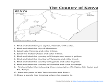
In this map completion worksheet, students observe a map and map scale of Kenya to find and label bodies of water, cities, countries, and the equator. Students answer 11 questions.
Curated OER
Make Your Map
For this map making worksheet, students make their own maps, draw symbols and place them in the map key area, and draw a compass rose to show directions for the map.
Curated OER
Map Analysis Worksheet
For this map analysis worksheet, students decipher what type of map they are using based on a complete list of criteria. Students then answer multiple questions based on their discoveries.
Other popular searches
- Map Skills Lesson Plans
- Map Skills Worksheets
- Elementary Map Skills
- Geography Map Skills
- Basic Map Skills
- Social Studies Map Skills
- Globe and Map Skills
- Beginning Map Skills
- United States Map Skills
- Map Skills, Continents
- Early Explorers Map Skills
- Free Map Skills Worksheets


