PBS
What's In a Name?
What is in a name? Eager historians trace the geographical history of places in the United States with Spanish names. Using a worksheet activity, clues, and web research developed in conjunction with the PBS "Latinos in America" series,...
Curated OER
How To Write a Social Studies Outline
One of the keys to success in school is organization. This resource leads learners through the process of creating an outline for a chapter from a social studies text. In addition, they review facts they have learned in their class...
Workforce Solutions
Workforce Solutions K-1 Lessons
Three lessons and one at-home connection explore 12 professions. In the first lesson, scholars examine an online map that displays all 12 careers alongside a video. Lesson two challenges class members to choose two of those careers to...
EngageNY
Close Reading of Bullfrog at Magnolia Circle: Predators and Prey
Reading is fantastic, especially when it's reading about bullfrogs. Kids get cozy with predator/prey relationships as they hone their information-reading skills. They start out as they read a portion of the text aloud, then they...
Curated OER
Tracking Fall's Falling Temperatures
Young meteorologists track weather from day to day and record results on graphs, maps, or other places. They see firsthand how weather temperatures trend cooler as fall progresses and practice grade-appropriate skills in geography (map...
Curated OER
These Maps are for the Birds
Students identify and study New York State Breeding Bird Atlas maps to learn where different bird species nest and how their distributions have changed over time. They also identify how maps serve as representations of a geographic...
Curated OER
Learning About Location: Charting the Path of the George W. Elder
Young scholars acquire a working knowledge of the geographical concepts: absolute location, relative location, longitude and latitude. They analyze primary sources that shows the physical and human characteristics of the places along...
Curated OER
What a Relief Map
Students create a map using cookie dough. In this geography lesson, students research the physical features of a country, draw a diagram and design and create a map out of cookie dough.
Curated OER
Mapping India
Students participate in an activity in which they place placards listing geographic features, landmarks, etc. in the correct place on a large fabric map of a given country. They also examine artifacts, photos, sounds/music, etc. from...
Curated OER
Schoolyard Geology
Discover that maps show information about an area and that they have common features like scales and legends. View an aerial map of your school and find features on the map such as the playground, roads, and trees. Trace the outline of...
Curated OER
The Coldest Place at the Bottom of the World
Students examine Ernest Shackleton's journey through the Antarctic and trace Shackleton's Actual Route on a map using longitude and latitude coordinates. Students compare his intended route with his actual and determine how far off...
Curated OER
Learning about Maps and Colors
First graders discuss "Harold and the Purple Crayon" and his drawings. In this neighborhood geography instructional activity, 1st graders learn to detect and classify places on a map including their home. Students recognize their address...
Curated OER
Cookie Mapping
Students study the components of a bedrock geology map through a hands-on activity involving a cookie and graph paper.
Curated OER
Mapping Plate Boundaries
Students discover plate boundaries based on the uneven geographic occurrence of geologic hazards. After discussing geologic hazards, students plot different sets of earthquakes and volcanic eruptions on maps.
Curated OER
Theme Map- The Rainforest
Students use graphic organizers to relate information. They read an article and insert information from the article to the theme map using a word processing program.
Curated OER
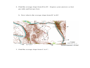
Slope and Topographic Maps
Students investigate slopes as they study topographic maps. In this algebra activity, students discuss and apply the concept of slopes to graphing and analyzing data.
Curated OER
Me on the Map Lesson 2
Learners analyze and interpret maps, globes and geographic information systems to define and identify cities, counties, states, countries and continents to create a booklet called me on the map. They also determine and calculate the...
Curated OER
Lesson 2: Mapping Our Home
Students recognize the importance of community participation in the census. For this U. S. Census lesson plan, students use map-reading skills to find answers and learn the difference between senators and members of Congress.
Curated OER
Lesson on GPS
Students investigate global positioning systems. In this technology and mapping activity, students view a PowerPoint presentation in which they identify the features of a GPS, state its uses, and follow steps to find a waypoint.
Curated OER
Mapping the Human Movement
Students research data on African-American emigration, place the data in a chart and create a human movement map. They also create another map using research on current immigration information.
Curated OER
Weather Forecasting
Students discover how to read a current weather map. In this weather forecasting lesson, students view weather maps from three consecutive days and observe how quickly weather moves and changes. Students review key terms associated...
Curated OER
Down at the Orchard
First graders examine what an apple orchard looks like and work with cardinal directions. In this apple orchard and direction lesson, 1st graders listen to Anne Rockwell's, Apples and Pumpkins, and Amy and Richard Hutchings', Picking...
Curated OER
Cardinal and Ordinal Directions
Students use a compass to locate cardinal and ordinal directions. In small groups, they describe and create a journey for their classmates using their compass. Groups create a scale map for their classmates to follow and relate this...
Curated OER
Giving Students a Little Latitude
Young scholars use a world outline map to locate places using coordinates of latitude and longitude. They answer questions about places based on their knowledge of the map and on their research and make up more questions of this sort...
Other popular searches
- Map Skills Lesson Plans
- Map Skills Worksheets
- Elementary Map Skills
- Geography Map Skills
- Basic Map Skills
- Social Studies Map Skills
- Globe and Map Skills
- Beginning Map Skills
- United States Map Skills
- Map Skills, Continents
- Early Explorers Map Skills
- Free Map Skills Worksheets


