Curated OER
Mapping the Human Genome
Students study DNA and how it was discovered. In this biology lesson students see the effects of mapping the human genome would have.
Curated OER
World War II New Guinea Campaign
Although the big picture for this lesson plan on the New Guidea Campaign of WWII is taking a field trip to the Douglas MacArthur Memorial, you can easily use it as a guide to an independent or group research project as well. However, if...
Curated OER
Bronx Zoo
Pupils prepare for a field trip to the Bronx Zoo. They use maps and descriptions of animal exhibits to give and interpret directions on how to navigate the zoo. They play games, participate in pairwork and whole class discussion.
Curated OER
Virtual Field Trip
This hands-on resource has future trip planners analyze graphs of mileage, gasoline costs, and travel time on different routes. While this was originally designed for a problem-solving exercise using a Michigan map, it could be used as a...
Curated OER
Virtual Field Trip
Are we there yet? Young trip planners learn about their state and plan a trip. They will select sites to see in three cities in their state, and record associated costs in a spreadsheet. While this was originally designed as a...
Curated OER
The Case of the "Lost Gorge:
Pupils examine the case of a map making expedition. In groups, they read a case study on "The Lost Gorge" in the Finger Lakes region of New York state. They examine maps and determine where the error in the map-making occured to end the...
Curated OER
Compass Rose
Keep it simple and visual when practicing directions using this compass rose labeling worksheet. Learners fill in the compass themselves, using cardinal and intermediate direction abbreviations. Consider using their compass on a map to...
Curated OER
Cause and Effect: Light Clusters and Geography
After viewing a map of lights at night over a variety of geographic formations, young topographers connect the location of light clusters to geographic features that encourage human settlement. They list causes and effects of large...
Curated OER
Early America: Jeopardy Game
Fifth graders can put their knowledge of early American life, the 13 colonies, and maps to the test when they play this Jeopardy game. The game covers terminology, famous people, and geography related to Colonial American times. Note:...
Curated OER
Global History & Geography: Latin America
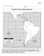
The instructions say to use a text-book to label 11 different regions in modern Latin America. If a text-book is not available a map can be found on-line and printed for student reference.
Curated OER
Leaf Peeping at Sharpe!
While this lesson focuses on observations made at Sharpe Reservation, another area could be used. Learners map out a route from their class to a nature preserve. Then, they identify the color and features of the leaves, and describe...
Keys to Literacy
Story Map
Recording the key elements of a story (title, setting, characters, problem, ending) on a story map graphic organizer provides primary readers a chance to practice identifying these elements and promotes reading comprehension. The...
Teacherfiles
Basic Story Map
Here’s an all-purpose story map template that readers can use to keep track of books read for class, of independent reading, and even for stories planned. Users identify the title, author, major characters, setting, and events from the...
PBS
Arthur Compass Rose
Keep your class headed in the right direction with this printable compass rose. Large and easy to read with a smiling picture of Arthur in the middle, this resource would make a fun addition to the desk of any primary grade...
Centers for Disease Control and Prevention
Statewide Smokefree Laws
Does your state allow smoking in public workplaces? What about in bars or restaurants? Take a look at an informative map of the United States to see what states do not allow smoking indoors, what states do not have indoor air laws on the...
Goodwill Community Foundation, Inc.
Directions and Distances
Describe where you are—and find out where you are going—with a beginning Spanish resource on directions and maps. Spanish learners repeat and practice direction words such as norte, este, and oeste, as well as measurement terms such as...
Los Angeles Unified School District
River Systems
Scholars must react to the ecosystems of a river. They use inquiry-based learning along with maps and visuals to better understand the impact of rivers on everyday life. To finish, they create final written projects and presentations.
Radford University
Getting Around Millbrook
When is the distance formula not accurate? Referencing a map of the school, pairs determine the walking distance between two locations. Creating coordinates for each location, pupils determine the distance between the two points and...
NASA
Air Temperatures Around the World: Student Activity
Check out climate anomalies just like NASA climatologists! Investigators use a GISTEMP map from NASA to analyze one month of climate anomalies. Scientists look for data extremes and generate possible explanations for observable...
EngageNY
Reading the Map and Beginning Chapter 1
Seventh graders begin their study of Linda Sue Park's A Long Walk to Water by discussing scenarios related to the novel with a partner. The discussion topics invite pupils to consider how various factors, such as war and poverty,...
Curated OER
Map Making
In this map making activity, students draw a map of their home including a map key. In this drawing activity, students create one map.
Curated OER
Story Mapping A Favorite Book
First graders create a diagram of a story by using the computer program Kidspiration. In this diagramming lesson plan, 1st graders will pick a book to write about. They then will plug in story elements of the book into the computer...
NASA
Biology Training Conclusion
Gravity is just one consideration when determining human habitability on a new planet. The lesson connects four different units and starts with connecting the various systems: planetary systems, human body systems, etc. After scholars...
Mary Pope Osborne, Classroom Adventures Program
The Backpack Travel Journals
Strap on those backpacks, it's time to travel through history with this literature unit based on the first four books of The Magic Tree House series. While reading through these fun stories, children create story maps, record...
Other popular searches
- Mapping Skills
- Semantic Mapping
- Concept Maps
- Story Mapping
- Cell Transport Concept Map
- Mapping Skills First Grade
- Mind Mapping
- Concept Mapping
- Gene Mapping
- Land Use Mapping
- Mapping Rivers
- Forestry and Mapping


