Curated OER
Mapping the New World Lesson Plan
Students compare two maps of the same area from different time periods. In this American History instructional activity, students look at two maps of the English colonies from 1636 and 1651. They discuss why the maps changed and predict...
Curated OER
Learning About the Map's Legend
Students draw a map of a room in their house and place a legend on it. They explain the legend orally.
Curated OER
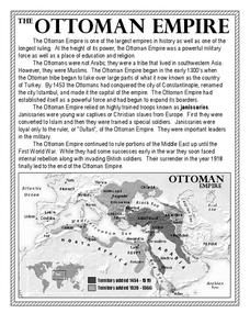
The Ottoman Empire
In this Ottoman Empire worksheet, students read a 1-page selection about the empire and examine a map. Students then respond to 5 short answer questions about the reading selection and the map.
Curated OER
Kazakhstan Outline Map
For this blank Kazakhstan outline map worksheet, students study the political boundaries of the country. This outline map may be used for a variety of geographic activities.
Curated OER
United States Map- Land Elevation
Students explore a physical map. In this map skills lesson, students discuss examples of elevation and investigate the symbols used to identify elevation on a map. Students use the map to identify various land elevations.
Curated OER
You Too Can Haiku
Learners explore the country of Japan. In this international studies activity, students utilize their geography skills to locate Japan on a map. Learners explore some Japanese customs and communities. Students use descriptive...
Curated OER
Blank US Map
In this blank outline map worksheet, students study the physical boundaries of the 50 states that make the United States. This outline map may be used for a variety of geographic activities.
Curated OER
Using Map Skills
Third graders study maps. In this U.S. geography lesson, 3rd graders explore directions on a compass rose and use a map scale to determine distances between two points on a map. They listen to a lecture and use their own maps to practice...
Curated OER
Reading Skills - Giving Directions
In this reading skills worksheet, learners identify places on a map. After reading a description of where each of the fifteen places is located, students match each building to the names of the places.
Constitutional Rights Foundation
Refugees From Vietnam and Cambodia
The United States may have pulled its troops from the Vietnam War in 1973, but the conflict was far from over for the citizens living in Asia at the time. An informative resource lets learners know about the wave of over 220,000...
Constitutional Rights Foundation
Refugees from the Caribbean: Cuban and Haitian “Boat People”
Should refugees fleeing poverty be allowed the same entrance into the United States as those fleeing persecution? High schoolers read about US foreign policy in the late 20th century regarding refugees from Cuba and Haiti, and engage in...
Curated OER
Create a Country
Learners work in small groups to list features and elements found on a variety of grade- appropriate maps. They develop a class list of map features and elements to draw from as they create a map of an imaginary country.
Curated OER
Understanding: Geography
Students explore their neighborhoods. In this geography lesson plan, students make a map of their neighborhood. They must include a key, natural terrain, buildings and streets. They also write a descriptive paragraph about their...
Curated OER
TE Lesson: Habitat Mapping
Students examine the current technologies used in mapping resources in the marine environment. They look at remote sensing, sounding, and underwater vehicles. They examine image from the benthic habitat produced by the GIS in order to...
Curated OER
Mapping School Grounds
Students map and analyze the natural and cultural environment of the school grounds. In small groups, they sketch the natural and cultural features of each side of the school building, create a map, participate in a class discussion,...
Curated OER
Thematic Maps of Your School
Students are able to list the essential elements of a thematic map, understand and use scale effectively to represent a geographic area, use research skills to develop a body of information, plan and draw an accurate thematic map based...
Curated OER
Cardinal Directions
First graders study cardinal directions on maps. In this geography lesson, 1st graders determine and show where North, South, East, and West are on various maps.
Curated OER
But Where Is It On This Modern Map? A problem-solving, mind-boggling experience!
Trace Columbus' voyages by locating them on 21st Century maps. Using a navigators lesson, 4th graders will examine the Age of Exploration and trace Columbus's routes accurately on laminated world maps using different maps. Note:...
Curated OER
Africa Map Quiz
In this online interactive geography quiz activity, students examine the map that includes all of Africa's countries. Students match each of the country names to the appropriate locations on the map.
Curated OER
Time Zones
Young scholars solve time zone problems and chart travel around the world. In this time zone lesson, students learn about the history of time zones and view a time zone map. Young scholars use the time zone map to solve time...
Curated OER
Making Maps
First graders create a map of their classroom that can be used to find a hidden treasure. They examine two- and three-dimensional objects and discover characteristics.
Curated OER
From Claws to Jaws: Atlantic Regions of the United States
Students explore New England, Mid-Atlantic, and southeastern regions of the United States. In this social studies thematic unit, students research a state and make a regional quilt. Students wrte a book report and read two novels...
Curated OER
Right Place, Right Time
Fourth graders complete mathematical word problems. They study the relationships among distance, speed, and time; and measure travel distances. They measure distances using a piece of string and a ruler and practice converting several...
Curated OER
Book of the Month - A Technology-Integrated Literacy Project
Students write a paragraph predicting what the book is about after viewing the front cover. They are given a copy of the Story Parts Maps, students are explained each story part. Students are explained that they most take notes on the...
Other popular searches
- Mapping Skills First Grade
- Esl Lessons Mapping Skills
- Mapping Skills Activities
- Geography Mapping Skills
- Mapping Skills Test
- Early Mapping Skills
- Geographic Mapping Skills
- Mapping Skills and Halloween
- Mapping Skills of China
- Alberta and Mapping Skills
- Topographic Mapping Skills
- Social Studies Mapping Skills


