Curated OER
Drake's West Indian Voyage 1588-1589
Middle schoolers investigate several maps detailing Sir Francis Drake's voyages. In this geography lesson, students practice reading maps and locating the precise locations of where Sir Francis Drake visited. Middle schoolers...
Curated OER
Valentine City
Students construct a small city on a table in the classroom. Each student is given a lot to develop. They give directions from one location to another, and write letters with correct addresses to their classmates.
Curated OER
Directions, Directions
Third graders review cardinal directions, moving around the room so that they are standing in the part of the room that is nearest the north, south, east and west. They are asked what would you do if they are lost? Pupils work as a...
Curated OER
Studying Snow and Ice Changes
Students compare the change in snow and ice over a 10 year period. In this environmental science lesson, students use the live data on the NASA site to study and compare the monthly snow and ice amounts on a map of the entire...
Curated OER
Learning European Geography
Sixth graders discover locations and countries in Europe by identifying them on a map. In this European geography lesson, 6th graders read the book The Lost Little Elephant, with their class and discuss the geography referenced in...
Curated OER
North American Biomes
For this Science worksheet, students color a biome map of North America. Students color the map by solving the clues listed on a separate sheet of paper.
Curated OER
Maps Can Help Us
First graders explore the geography of Montana by analyzing geographic maps of the area. For this Native American reservation lesson, 1st graders discuss the similarities and differences between reservations in the state of Montana....
Curated OER
GPS Treasure Hunt
Students explore geography by participating in a treasure hunt activity. In this Global Positioning System activity, students define the terms latitude and longitude while utilizing an electronic GPS device. Students view a PowerPoint...
Curated OER
Walking on Maps
Learners are introduced to the various types of maps and their functions. As a class, they play a game similar to twister to review map concepts. They answer questions about the map and use the internet to view larger maps of the world.
Curated OER
Introduction To Topographic Map Activities
Students discuss different types of maps, their similarities and differences. Using a Topographical Maps CD-rom program students create their own map.
Curated OER
Continents and Oceans
Students identify oceans and continents and their locations on a map. They color-code and label their own map of the world's continents and oceans. They play the game Continents and Oceans to identify specific areas.
Curated OER
Science Inquiry Lesson: Mapping Project
Learners explore the methods of creating maps. They create a map of Animas River Park using a compass and measuring tape, develop a single map from the team map sections, and devise another map of the Animas River Park using a GPS unit.
Curated OER
Treasure Hunt
Students find lost "treasure" using a treasure map after being shown a map that you have created where terms and symbols are discussed. The class is divided into small groups where they locate your treasure and then read a section from...
Curated OER
Middle Ages Traveler
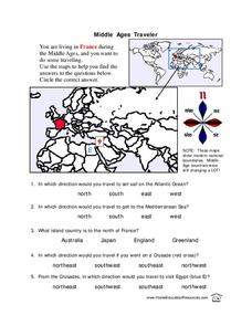
In this map worksheet, students are given three maps of France to use to answer multiple choice questions. Students complete an activity from the perspective of a Middle Ages traveler.
Curated OER
Europe Before and after WWI
Eighth graders compare and contrast maps of Europe before and after World War I. In this World War I activity, 8th graders color and label maps of Europe prior to the war and after it. The historical maps can be accessed online.
Curated OER
European Union Map Quest
Sixth graders identify countries of the European Union. They locate countries of Europe on a map and pair with a student to complete a blank map of Europe. They label each country and complete worksheets for the European Union. They...
Curated OER
Mediterranean Lands: A Pilgrimage Through Time and Space
Students will use context clues and examine several maps to answer series of short answer questions over range of geographical topics, identify specific places, practice using GoogleEarth to compare satellite views to those produced two...
Curated OER
Planting Time
Students research crops grown in the United States. In this agriculture instructional activity, students identify various crops cultivated across the United States as they create charts and maps that note the information.
Curated OER
Learning to Read a Regional Map
Students locate the local community, surrounding communities and major geographic features of the SE Utah and the Four-Corners region on a map, after receiving direct instruction.
Curated OER
Latitude and Longitude- Online Interactive
In this maps worksheet, learners learn about longitude and latitude by reading a two paragraph text and studying two maps. Students answer 9 fill in the blank questions. This is an online interactive worksheet.
Curated OER
The Changing Landscape
Students explore how the landscape is constantly changing. In this landscape lesson, students identify a building under construction on the Landscape Picture Map. Students discuss the purpose of the construction and the effect on the...
Curated OER
The Geography of Europe
Students examine maps of Europe. In this geography skills lesson, students interpret several maps to determine the boundaries of the European Union and respond to assessment questions about the maps.
Curated OER
Lesson Design Archaeology- U.S. Map
Students examine the U.S. map and identify cultural areas. In this archaeology lesson, students locate cultural areas on the U.S. map and fill in the proper locations.
Curated OER
Mexico Map
For this blank outline map worksheet, students study the political boundaries of the North American country of Mexico. This map may be used in a variety of classroom activities.


