Curated OER
Map of Uruguay
Useful guide to quick facts and statistics on Uruguay. Includes a map and image of the flag.
Curated OER
Map of Bolivia
Provides quick facts and information on geography, history, government, culture, population, religion, and travel advisories for the country of Bolivia. Includes a map and image of the flag.
Curated OER
Map of Brazil
Useful tool for finding quick facts and information on Brazil's culture, geography, religion, population, and travel advisories. Includes a map and image of the flag.
Curated OER
Map of Paraguay
A country profile of Paraguay featuring quick facts and information and statistics on culture, population, language, geography, history, religion, and travel advisories. Includes a map and image of the flag.
Curated OER
Map of Barbados
Good reference source that has individual sections of information about the geography, people, government, economy, history, and foreign relations of Barbados. Includes a map and image of the flag.
Curated OER
Map of Antigua and Barbuda
Good reference source that has individual sections of information about the geography, people, government, economy, history, and foreign relations of Antigua and Barbuda. Includes a map and image of the flag.
Curated OER
Map of Belize
Good reference source that has individual sections of information about the geography, people, government, economy, history, and foreign relations of Belize. Includes a map and image of the flag.
Curated OER
Map of Cuba
Good reference source that has individual sections of information about the geography, people, government, economy, history, and foreign relations of Cuba. Includes a map and image of the flag.
Curated OER
Map of Jamaica
Useful reference source that has individual sections of information about the geography, people, government, economy, history, and foreign relations of Jamaica. Includes a map and image of the flag.
EL Education
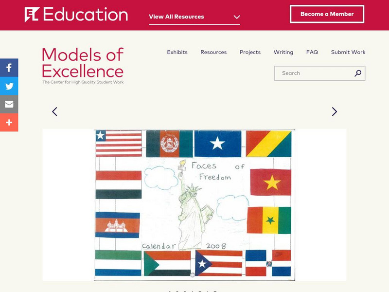
El Education: Faces of Freedom Calendar
This calendar was created by 3rd graders in Rochester, New York, as part of a learning expedition on immigration. As a way to honor the experiences of young immigrants and to learn about immigration, students from this class interviewed...
Mark Harden's Artchive
The Artchive Jasper Johns
This site provides access to 29 images of work by American artist Jasper Johns. Popup ads must be exited before you can see the image.
Curated OER
Ohio State Flag
Covers comprehensive information regarding Ohio history, famous people, cities, geography, state parks, tourism, and historic sites. A fact sheet of information and a quiz are also available.
Enchanted Learning
Enchanted Learning: Zoom School: China
Learn about the fourth-largest country in the world at this site from Zoom School. Explore China's Great Wall, its people, animals, and more, and find maps and basic information about its geography, flag, government, and so on.
Houghton Mifflin Harcourt
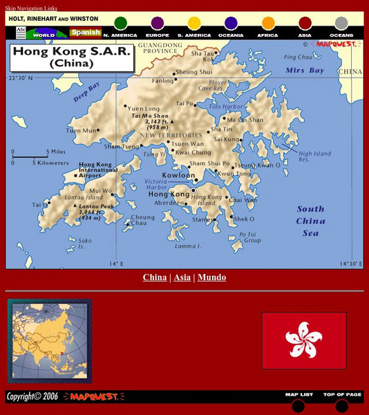
Holt, Rinehart and Winston: World Atlas: Hong Kong
See a map of Hong Kong and an image of Hong Kong's flag. The map includes names of cities, bodies of water, and elevations of Tai Mo Shan and Lantau Peak.
Hans Lohninger
Photo Globe: Bolivia
Presents many general country specific facts about Bolivia in a well organized chart form. This site is enriched by links to maps and an image of the Altiplano salt flats.
Houghton Mifflin Harcourt
Holt, Rinehart and Winston: World Atlas: Iran
Find all the basic data on Iran on this page. Contains a clear map from "MapQuest", flag and facts in a list format. Categories include languages, religions, life expectancy, currency, GDP, industry, agriculture and more.
Houghton Mifflin Harcourt
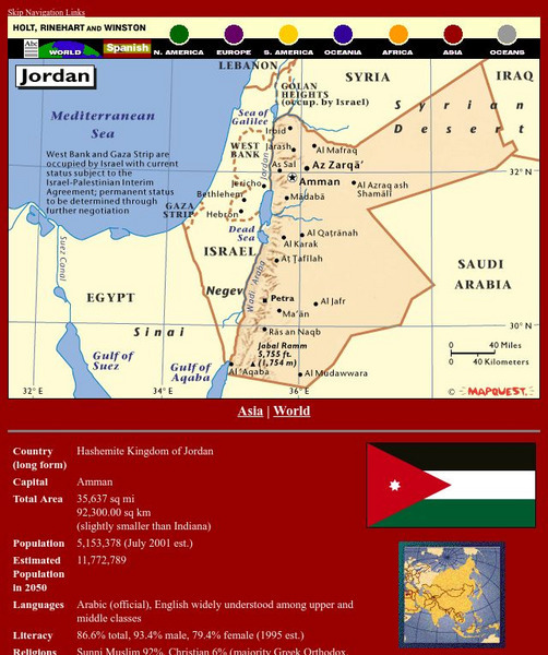
Holt, Rinehart and Winston: World Atlas: Jordan
Find all the basic data on Jordan on this page. Contains a clear map from "MapQuest", flag and facts in a list format. Categories include languages, religions, life expectancy, currency, GDP, industry, agriculture and more.
Houghton Mifflin Harcourt
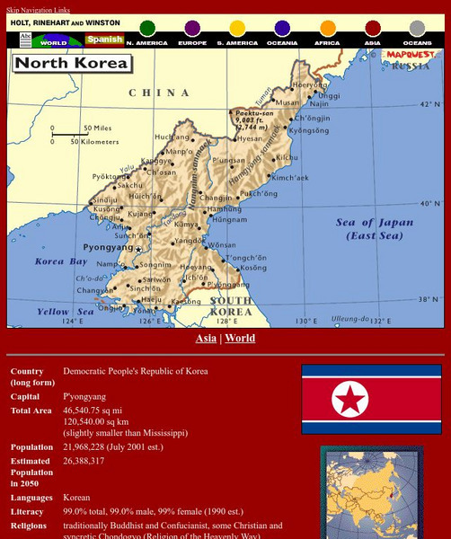
Holt, Rinehart and Winston: World Atlas: North Korea
Find all the basic data on North Korea on this page. Contains a clear map from "MapQuest", flag and facts in a list format. Categories include languages, religions, life expectancy, currency, GDP, industry, agriculture and more.
Houghton Mifflin Harcourt
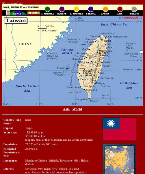
Holt, Rinehart and Winston: World Atlas: Taiwan
Grab quick facts about Taiwan (capital, total area, population, languages, literacy, religions, government, currency, industry, and more) while looking at a map, complete with cities, elevations, bodies of water, longitude, and latitude....
Houghton Mifflin Harcourt
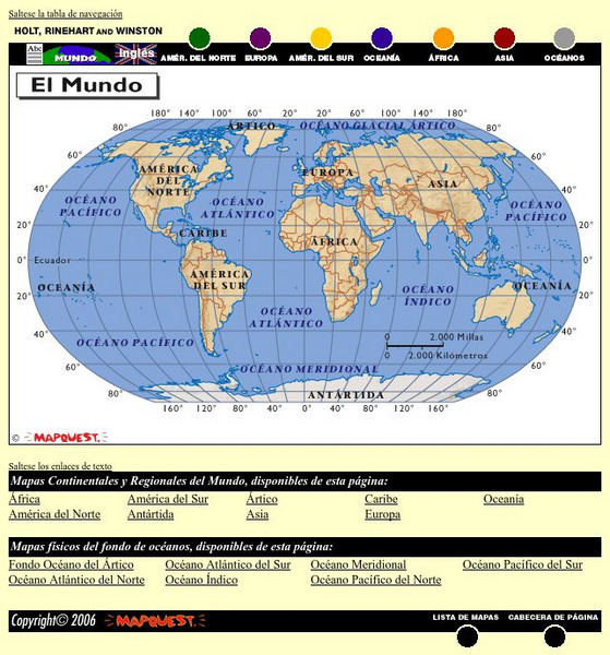
Holt, Rinehart and Winston: El Mundo
This is an online resource in Spanish to the countries of the world, detailed maps of these countries from Mapquest, their flags, and statistical data. Statistical data includes literacy rates, industry, agriculture and natural...
Houghton Mifflin Harcourt
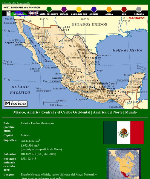
Holt, Rinehart and Winston: America Del Norte: Mexico
This site has a map of Mexico in Spanish, with informational data also presented in Spanish about the country. Land mass, population, life expectancy, literacy, industry, agriculture, minerals and resources are among the topics...
Houghton Mifflin Harcourt
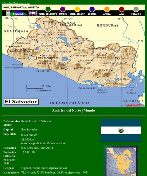
Holt, Rinehart and Winston: America Del Norte: El Salvador
This site has a map of El Salvador in Spanish, with informational data also presented in Spanish about the country. Land mass, population, life expectancy, literacy, industry, agriculture, minerals and resources are among the topics...
Houghton Mifflin Harcourt
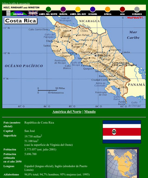
Holt, Rinehart and Winston: America Del Norte: Costa Rica
This site has a map of Costa Rica in Spanish, with informational data also presented in Spanish about the country. Land mass, population, life expectancy, literacy, industry, agriculture, minerals, and resources are among the topics...
Other popular searches
- Australian Maps and Flags
- Thai Maps and Flags
- Maps and Flags Caribbean
- Maps and Flags Mexico
- Area Studies Maps and Flags
- Illinois Maps and Flags


