Curated OER
The Big Blue
Third graders create paper mache globes with balloons. They label the 4 oceans on their balloons with reference to large wall map, classroom globe, and Encarta Virtual Globe CD-ROM projected on large screen TV with Tvator or other...
Curated OER
African Rattles
Students locate Africa on the map or globe and tell one important fact about the continent. They follow directions and demonstrate the proper process of making an African Rattle.
Curated OER
Introduction to Oceans
Students complete a variety of activities in preparation for a unit on oceans. They discuss their own proximity to the ocean, identify and name the oceans on a globe, and in small groups identify facts about a selected ocean. Students...
Curated OER
Holy Mole
Third graders explore the Mexican sauce Mole and the culture of Mexico. In this Mexican culture lesson, 3rd graders find Mexico on the map and access prior knowledge about the country. Students discuss Mexican foods....
Curated OER
Ireland: the Emerald Isle
Third graders complete a unit of study that examines several perspectives of Ireland. They explore how climate shapes Irish culture, reference historical and political maps, compute exchange values for Irish money, complete worksheets,...
Curated OER
Around the World in 5 Days
Students explore continents, draw map, discuss cultures, use research to learn geography, and investigate cultures.
Curated OER
Landforms: Geomorphology of Arkansas
Second graders create large, salt dough maps of Arkansas and the natural regions in the state created by geographical and morphological features.
Curated OER
Interactive Atlas
Second graders examine the different ways people move from place to place in a neighborhood. Using the interactive online atlas MapQuest, they identify the various ways people move around their own neighborhood by creating a map and...
Curated OER
Volcanic Activity in the U.S.
Students locate and map ten volcanoes in United States, create chart comparing volcanoes by last eruption, type of volcano, location, and interesting fact, and create Powerpoint slide show describing basic
information about volcanoes and...
Curated OER
Apple Kinds to Products
Students become familiar with various kinds of apples and the tree they grow on. In this Apple tree lesson, students recognize the differences between apples and can identify what happens to apples in different seasons. ...
California Academy of Science
Tropical Belt
Where in the world is the equator? Explore a world map with your class, coloring in oceans, continents, and rainforests while locating the three major lines of latitude: the equator, Tropic of Cancer, and Tropic of Capricorn. Discuss how...
Prairie Public Broadcasting
Egyptian Pyramids Virtual Field Trip!
A virtual field trip takes enthusiastic travelers to the pyramids of Giza. Using Google, scholars explore the grounds of the ancient pyramids found in Egypt then complete three worksheets: a photo analysis page, a reflection sheet, and a...
Curated OER
Terrabagga Activity Using a Magnetometer
Clever! Earth science learners construct a model of a planet containing a magnetic core. The planet, Terrabagga, is made out of a paper grocery bag, magnets, a dead D battery, and rubber bands. Pictures of each step of the construction...
Curated OER
Plate Tectonics: Sixth Grade Lesson Plans and Activities
Here is a set of pre-lab, lab, and post-lab lesson plans on plate tectonics. After completing the previous labs on volcanoes and earthquakes, sixth graders use the gained knowledge to explore plate boundaries and the movement of...
Curated OER
Using the Four Main Directions in the Classroom
Students use the four main directions to locate features in the classroom. In this direction lesson, students review the 4 main directions using a world map. Students use a magnetic compass to locate the north wall in their classroom and...
Curated OER
Investigating Haiti
Students engage in a activity that is about the island of Haiti. They conduct research using a variety of resources. The information is used in order to help students locate the island on a map. They answer questions while participating...
Curated OER
Geo-Town
Second graders use a checklist to construct a Geo-Town map including a compass rose, a map key, and a paragraph about a walk around Geo-Town, using appropriate geometric and directional vocabulary to identify the two-dimensional figures...
Curated OER
Children in the United States and Japan
Students locate Japan on a map or globe and describe the relative location of Japan. They use the Internet to investigate cultural characteristics of children in the United States and in Japan. They use a Venn Diagram as an...
Curated OER
Explorers of the Mighty North
Learners access the Internet to research the journey made by Rear Admiral Peary and Matthew Alexander Henson to the North Pole. They locate the North Pole on maps and globes. They present oral reports to classmates on their research.
Curated OER
Making Sense Of A Round World On A Flat Surface
Young scholars engage in a instructional activity that is concerned with the development of geography skills. They take part in a number of activities that center around finding and traveling to different locations. The instructional...
Curated OER
Flight Paths of Orbiting Satellites
Students examine the path a satellite follows as it orbits the earth. In this space science activity, students use a globe as they illustrate a satellite in its orbital plane, then plot points on the satellite's path on the globe to see...
Curated OER
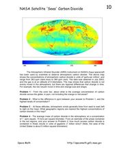
NASA Satellite 'Sees' Carbon Dioxide
In this atmospheric carbon dioxide worksheet, students observe a map showing the concentrations of atmospheric carbon dioxide taken by the Atmospheric Infrared Sounder instrument. Students solve 4 problems using the map. They determine...
Curated OER
Exploring the World's Geography
Students discuss the seven continents of Earth and the diverse geography. After discussion, they create their own paper-mache globes which properly display all seven continents, the equator, and the prime meridian. They conduct research...
Curated OER
Donde en el mundo estas?
Students give & follow directions given in Spanish, using oral, written and graphics. They use maps, globes, atlases, and remote sensing, GIS, and GPS to acquire and process information about places.
Other popular searches
- Comparing Maps and Globes
- Reading Maps and Globes
- Communities Maps and Globes
- Examining Maps and Globes
- Using Maps and Globes
- Free Maps and Globes
- Maps and Globes Activity
- Maps and Globes Migration
- Globes and Maps
- Maps, Globes and Atlases
- Atlases Maps Globes
- Globes and Maps Continents


