Other
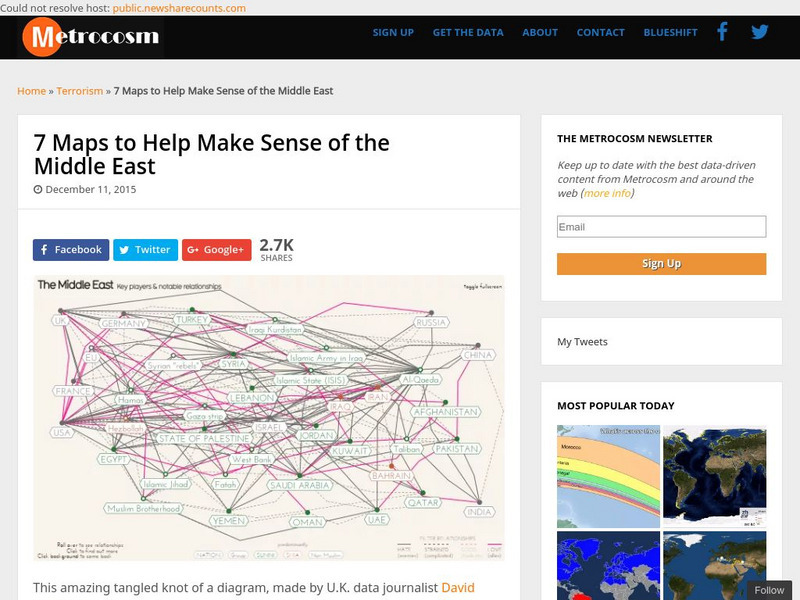
Metrocosm: 7 Maps to Help Make Sense of the Middle East
Keep up to date with the everchanging Middle East Region. The Middle East has been a tangled web of alliances since WWI. These maps attempt to make sense out of the this often confusing area. The 7 maps show the relationships among...
Middle East Policy Council
Mepc: Teach Mideast: Comparing Maps of the Middle East
A lesson plan to explore the Middle East region via maps and classroom discussion to better understand the Middle East. An Internet connection is needed to utilize the links provided.
Choices Program, Brown University
Choices: u.s. Policy in the Middle East: Analyzing Political Cartoons
Multi-media resources including video, PowerPoint, articles and maps from which students explore current issues in the Middle East and their relation to U.S. policy and interpret political cartoons on Middle East politics.
University of Chicago
University of Chicago Library: Teaching the Middle East: Resource for Educators
An overview of the cultures, contributions, history, peoples, and geography of the Middle East developed specifically for educators. Learning modules, essays, maps, scholarly perspectives, resource and image banks, framing questions, and...
Curated OER
University of Texas: Map of Southern Asia
This political map shows the countries and capitals of the Middle East and South Asia as well as other countries in Asia.
Other
Owl & Mouse Educational Software: Middle East Map Puzzle
This site has a puzzle of the countries of the Middle East that you can play online.
Lizard Point Quizzes
Lizard Point: Middle East: Countries Quiz
Test your geography knowledge by taking this interactive quiz over the countries of the Middle East.
Lizard Point Quizzes
Lizard Point: Middle East: Bodies of Water Quiz
Test your geography knowledge by taking this interactive quiz over the bodies of water in the Middle East.
Latimer Clarke Corporation
Atlapedia: World Maps/middle East
Learn the locations and countries in the Middle East from this political map. Click on the link at the top of the page to see a physical map of the same region. Clicking on the country's name will take you to information about that country.
Curated OER
University of Texas: Middle East
This map from the Perry-Castaneda collection shows a relief map of the Middle East.
Princeton University
Princeton University: Maps of the Islamic Middle East
This site from the Princeton University includes a map collection from Roolvink's "Atlas of the Middle East" with a variety of historical maps on Islam.
CBS
Cbs News: Middle East Countries
Discusses each country in the Middle East and how it is affected by the problems that are going on in the region. Click on the tiny map in the upper left-hand corner to access the list of countries.
New York Times
New York Times: Middle East
[Free Registration/Login Required] The New York Times covers the latest news, issues and events occurring in the Middle East. In addition to breaking stories, the New York Times also provides focused information and maps.
Ducksters
Ducksters: Geography for Kids: Middle East
Investigate the countries and geography of the Middle East. Study the flags, maps, facts, exports, natural resources, economy, populations, and languages of the Middle East.
ClassFlow
Class Flow: Middle East Map
[Free Registration/Login Required] Using interactive tools, students will discover the many regions of the Middle East using graphic maps and finally, rearrange the jigsaw pieces to recreate the full map.
Ducksters
Ducksters: Geography Games: Map of the Middle East
Play this fun geography map game to learn about the locations of the countries of the Middle East.
University of Texas at Austin
The Perry Castaneda Library Map Collection
This collection contains more than 250,000 maps covering all areas of the world, and ranging from political and shaded relief maps to the detailed and the historical. Select from a region of the world or an area of highlighted interest.
University of Texas at Austin
Perry Castaneda Library Map Collection: Israel
The Perry-Castaneda Library at the University of Texas provides an outstanding collection of maps of the country of Israel. Also links to maps from other online sources.
CBS
Cbs News: Mideast Conflict
An overview of the Middle East. Provides an in-depth analysis of the Middle East and and how events and people have influenced the region. Gives interactive maps, video, and biographies of the world leaders that have impacted the region....
Curated OER
University of Texas: Saudi Arabia: Small Political Map
This map of Saudi Arabia is very easy to read. It shows the major cities and its location in relation to other countries in the Middle East. From the Perry-Castaneda Collection.
NOAA
Noaa: Cpc: Regional Climate Maps
Provides large colorful maps of climate data about each continent for the current week, month, or previous quarter.
Curated OER
Middle East Map
NPR reports on the neighboring countries to Iraq in the Middle East: Jordan, Syria, Kuwait, and Saudi Arabia. How are these countries coping with the violence so close at hand? The report contains audio and a series of pictures taken in...
National Geographic Kids
National Geographic Kids: Israel
Click-through facts-and-photo file about Israel's geography, nature, history, people and culture, and government. Includes a map of the country that pinpoints its Middle East location.


