Curated OER
TOPSY TURVY MAPS
Eighth graders use the data analyzer and motion detector to collect data and measure distances. They create topographic maps drawn to scale of a given setup and relate the concepts to the creation of historical ocean maps.
Curated OER
Discovering New Mexico
Seventh graders discuss the elements of maps and using basic linear measurement. They calculate the distance between the cities and create a simulated journey around New Mexico using a road map. They write out the directions for their...
Curated OER
MAP UNIT
First graders investigate how maps are used to identify different locations. They will also appreciate how there are different types of maps for their purposes. Finally students study how maps contain symbols that represent real places.
Curated OER
Spatial Connections
Students use maps, scales, and describe locations in order to learn about spatial sense. In this spatial sense lesson plan, students participate in many activities for this spatial sense unit that should last throughout the year.
Curated OER
Colonial Vacation Planner
Students plan a family vacation to states that were among the original 13 colonies. The groups determine which state they visit, map their route, calculate the mileage, and determine how much money they spend on gasoline.
Curated OER
The Sustainable Olympics
In this sustainable Olympics worksheet, students utilize a large map of the British Isles, map scale a long piece of string to calculate the approximate distance between their school and 8 locations where some of the Olympic events may...
Curated OER
Message in a Bottle
Sixth graders write a short story about being stranded on a deserted island. After a brief geography review of locations at various latitudes and longitudes, 6th graders draft their story about being stranded. They use sensory and...
Curated OER
Flat Earth Society
Students explore map distortion. In this geography lesson, students compare Mercator projection maps to globes in order to understand the strengths and weaknesses of projection maps.
Curated OER
Getting to the Core of World and State Geography
Students create topography relief maps. In this geography skills lesson, students review geography core knowledge skills, design and make a state relief map, and compile a student atlas.
Curated OER
Measure Up!
Students examine parallax and angular measurements. In this investigative lesson students calculate distances of objects and map their results.
Curated OER
Absolute And Relative Location
Students create a map that takes someone from school to their home using both relative and absolute locations. They assume the person using the map is unfamiliar with the area.
Curated OER
Where in the World Am I: Latitude And Longitude
Learners demonstrate their knowledge in using latitude and longitude measurements to find locations on a map, especially places in Hawaii.
Curated OER
Design an Island
Students make a map of an imaginary island using the topographic symbols provided from a worksheet. Students place lakes, dwellins, reefs, etc. in areas where they would logically be located from understanding how the topography of an...
Curated OER
Math with Maps and Globes
Young scholars round out their math skills with these ‘round the world' ideas. In this math and geography lesson, students try out time zone sticks, a polar race, and tic-tac-globe to engage them in learning more about globes and the...
Curated OER
Earth on the Earth
Fourth graders plot points on a graph and transfer those coordinates onto a large scale model resulting in an outline of the Western Hemisphere. They identify the major geographical landforms of the Western Hemisphere.
Curated OER
Geography Worksheet
In this geography skills worksheet, students respond to 14 short answer questions by using maps and atlases. The maps and atlases are not included.
Curated OER
Our 50 States
Students identify the location of the 50 states using an interactive map. They practice geography skills by playing a fun game. Pupils become familiar with the state abbreviations for the US states. Students become familiar with the...
Curated OER
The Pilgrims
Students use distance measuring tools to follow directions and chart the path the pilgrims made from Plymouth, England to Boston, Massachusetts. In this Pilgrim voyage lesson, students use a map to chart the distance traveled by the...
Curated OER
Fishes and Amphibians
In this fish and amphibian characteristics instructional activity, students will two idea maps to compare fishes and amphibians. Students will complete 2 short answer questions based on these idea maps.
Curated OER
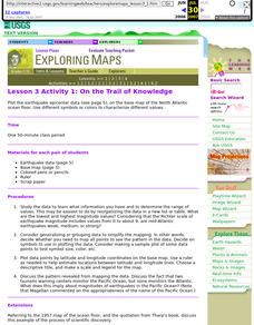
Lesson 3 Activity 1: On the Trail of Knowledge
Students plot the earthquake epicenter data on the base map of the North Atlantic ocean floor using different symbols or colors to characterize different values.
Curated OER
Mud Maps
Students discuss the location of stores, buildings, and homes in their community. Afterwards, they create a 'mud map' demonstrating the route from one point to another. In pairs, students read travel directions from a brochure, while...
Discovery Education
Architects in Action
Hands-on and real-world applications are great ways to teach mathematical concepts. Creative thinkers examine how ratios are used to create scale models of buildings and structures. They practice working with ratios by looking at a map...
Chicago Botanic Garden
Historical Climate Cycles
What better way to make predictions about future weather and climate patterns than with actual climate data from the past? Young climatologists analyze data from 400,000 to 10,000 years ago to determine if climate has changed over...


