Curated OER
The Crash Scene
Fifth graders explore geography by participating in a mapping activity. In this engineering lesson, 5th graders identify the differences between latitude and longitude and practice locating precise points on a globe or map. Students...
Curated OER
A Real Life Example of the Distance Formula
Young scholars answer the following question: "Using the lines of latitude and longitude, what is the distance (in degrees) if you were to travel from NASA Dryden to NASA Ames?" They use the distance formula to find the distance...
Curated OER
Distance Formula
Students determine the distance between two points. In this distance formula lesson, groups of students determine the distance between points in real life situations. They calculate the distance from one point in the...
K12 Reader
Where On Earth Are You?
What do we use to determine the exact locations on the earth? Your kids can learn all about compass roses and latitude and longitude. Test understanding with the five reading comprehension questions included on the page.
Curated OER
Maps- Looking at Map Scales
In this map scale worksheet, students examine how to convert measurements on a map. They read 5 examples before completing 8 multi-step conversion problems. They insert the answers in an online version of the worksheet to determine if...
Curated OER
Map Adventures
Young scholars explore the relationship between a scale drawing and actual distance. In this mapping lesson, students use an amusement park map to determine distances and what they would be like in real life.
Curated OER
How To Read A Map
In this map skills worksheet, learners view a map and answer five short answer questions by using the map key as a...
Curated OER
Make a Classroom Map
Students map the items in their classroom to explain the importance of coordinate systems.
Curated OER
Map Scale
Third and fourth graders are introduced to the concept of map scale. Using an illustration, they discuss if it shows the actual size of the object and why scale is used to represent areas. They use some items in the illustration to...
Teach Engineering
What is GIS?
Is GIS the real manifestation of Harry Potter's Marauders Map? Introduce your class to the history of geographic information systems (GIS), the technology that allows for easy use of spatial information, with a resource that teaches...
Curated OER
Measurement Review
Learners measure the distance between two points. In this measurements lesson plan, students read books about birds that migrate and measure the distances that each bird flies when it migrates. Learners discuss the...
Curated OER
Map Studies - Estimate And Measure Distance
First graders explore estimating and measuring distances. They analyze and discuss a map of New York State, make estimations, measure distances using yarn, and calculate total distances between cities on the map.
Curated OER
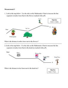
Measurement 3: Rulers
In this measurement worksheet, students measure the linear distance, in inches, between stated objects. Next, they determine the actual distance, in miles.
Curated OER
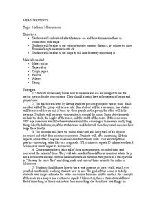
Math and Measurement
Students use the correct tool to measure distances. In this geometry lesson plan, students use an odometer and ruler correctly as they study maps. They describe how far way something is.
Curated OER
Right Place, Right Time
Fourth graders complete mathematical word problems. They study the relationships among distance, speed, and time; and measure travel distances. They measure distances using a piece of string and a ruler and practice converting several...
Curated OER
Map the Civil War
Students explore the Civil War through original maps. In this mapping instructional activity, students calculate distance and show it on an original map. Students examine the type of landscape and its landmarks and draw symbols on...
Curated OER
Plotting Earthquakes
Students plot earthquakes on a map. In this lesson on earthquakes, students will explore recent earthquake activity in California and Nevada. Students will plot fault lines and earthquake occurrences on a map.
Curated OER
Baseball Challenge: Social Studies TCAP
Using a baseball theme, this presentation provides a review of social studies topics covered in sixth grade. Students play a game in which they score based on the answers to various questions involving Ancient Rome, Ancient Greece, map...
Curated OER
Unit V: Worksheet 2 - Constant Force
Physics learners studying force and acceleration practice solving eight problems with this assignment. They calculate acceleration and deceleration, net force, and distances required for stopping a moving object. Kinematics equations and...
Curated OER
The Pilgrims
Learners use distance measuring tools to follow directions and chart the path the pilgrims made from Plymouth, England to Boston, Massachusetts. In this Pilgrim voyage lesson, students use a map to chart the distance traveled by the...
Curated OER
Map Maker Map Maker
Young scholars create their own maps. In this map making lesson plan, students go to Microsoft Word and create a chart. They label directions, buildings, streets, and distance.
Curated OER
How Big is the Playground: Creating a Map
Learners create a topographical map of an area outside of the school. In this mapping lesson, students compile data on angles, distances, and key landmarks for a predetermined area on the school grounds to create a map using Geometer's...
Center for History Education
Maryland During the Secession Crisis
While many think the United States was neatly divided between Northern and Southern states during the Civil War, border states like Maryland are more complicated. Using hands-on activities to measure distance and primary sources,...
Curated OER
Scaling in Maps
In this recognizing map scale ratios worksheet, students use ratios and centimeter measurements to calculate the distances in reality. Students solve 8 problems.


