Concord Consortium
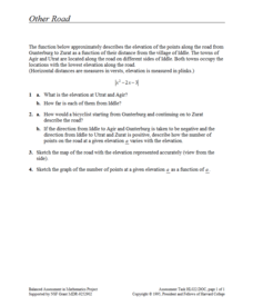
Other Road
Take the road to a greater knowledge of functions. Young mathematicians graph an absolute value function representing a road connecting several towns. Given a description, they identify the locations of the towns on the graph.
K12 Reader
Absolute Location
Where in the world are we? As a reading comprehension exercise, kids read a short passage about navigation using latitude and longitude, and then respond to a series of questions based on the article.
California Academy of Science
Earthquakes and Tectonic Plates
Here is a comprehensive package in which middle schoolers learn about types of seismic waves, triangulation, and tectonic plate boundaries. Complete vocabulary, colorful maps, and a worksheet are included via links on the webpage. You...
Curated OER
Unit 19 Scale Drawing
In these scale drawing worksheets, learners read the distance problems and select the answer from the choices. Students complete 9 problems.
Curated OER
Map Scale and the Pioneer Journey
Fourth graders use a map, ruler and calculato to determine the distance the pioneers traveled from Nauvoo, Ill. to the Salt Lake Valley.
Curated OER
Globe Lesson 4 - The Compass
Students study compass' and their use in navigation. In this compass lesson, students use a compass and a globe to answer the questions about navigation.
Curated OER
White Bear Lake Fitness Challenge
Students participate in fitness challenge. After choosing a destination they would like to visit, students record their mileage to their destination after riding on bikes and walking on treadmills. Students receive an incentive...
Curated OER
Mapping of the Earth's Past
Students create a scale model time linen of the Earth's 4.6 billion year history. They calculate a scale that can fit on a very long register tape then label each geologic era. They use text books to annotate each era with major geologic...
Curated OER
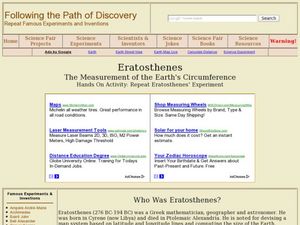
Eratosthenes
Students examine what Eratosthenes is and the history behind him. In this earth lesson students complete a hands on activity to repeat Eratosthenes' experiment.
Curated OER
Civil War Naval Strategy
Students apply critical thinking skills to war strategy. In this Civil War map lesson, students use their knowledge of latitude and longitude as well as scale to respond to questions regarding Civil War battle strategies.
Curated OER
Exploring the Hudson in 1609
Learners follow the journey of Henry Hudson down the river with his name. Using journal entries and maps, they learn about its exploration. They use maps to identify stages of the journey, and practice converting distances into miles.
Curated OER
Minty
Students investigate, read, and discuss about other famous Afro-American leaders. Students compare/contrast slaves home, activities, etc. with that of Afro- Americans today. Students create a time line to post on the wall of Harriet's...
Curated OER
Measurement and the Illampi Mound Colony
Young scholars comprehend the basic units of measurement, scale, plotting, and basic grids. Students practice their estimation
and measuring skills and will demonstrate their ability to work well in groups.
Curated OER
Globe Lesson 17 - Alaska and Hawaii - Grade 4-5
Learners develop their globe skills. In this geography skills lesson, students explore the area added to the United States when the Alaskan territory was purchased from Russia.
Curated OER
Miles Mania- Rounding to the Nearest Hundred Worksheet
For this mileage and rounding worksheet, 3rd graders read distances between cities as shown on a map at the top of the page. They fill in a table using the names of the cities as determined by the rounded mileage between them. They...
Curated OER
Scale Basketball
High schoolers understand that a spreadsheet can be used to find the best scale to use in a model. They place the distances of the planets of the solar system to the Sun in one column of the spreadsheet. Students try different scales so...
Curated OER
Anza and Font in Search of Latitude
This is an integrated lesson that incorporates Social Studies, Science, and Mathematics. In Social Studies, 7th graders complete an online interview and complete an online worksheet about latitude of sites on the Anza trail. In Science...
Curated OER
Globe Skills Lesson 3 Voyage to the New World
Students explore the globe. In this globe skills lesson, students use their knowledge of latitude and longitude to respond to questions regarding Christopher Columbus's maiden voyage to the Americas.
Curated OER
Cross Country Adventure
Students practice measurement and geography in this lesson. They build a Lego vehicle using an RCX. They predict how many seconds it will take their vehicle to reach a specific state on the United States of America map that each group of...
Curated OER
Water Monitoring Vocabulary
As the title implies, this is a list of vocabulary terms relating to water monitoring. If your ecology class is learning about how to test water quality, this will be an appropriate reference sheet for them. As a bonus, if you live in...
Curated OER
Volcano Contour Models Activity and Tracing the Highs and Lows in San Francisco
Students investigate how to draw topographic contours and read topographic maps.They examine the topography of San Francisco and contrast the elevation of different points within San Francisco.
Curated OER
ExplorA-Pond:3rd Grade Shapes & Fractions
Young scholars, using a map, drawing or aerial view of a pond, represent the shape of the pond using simple geometric shapes or fractions of those shapes. They identify the numerator and denominator in each fraction created.
Curated OER
Basic Math - Plan a Cruise
Students measure distances and report them in fractions. They convert fractions to decimals and multiply decimals.
Curated OER
Blazing the Trail
Learning about proportions through measuring and mapping distances is the focus of this real-world math instructional activity that doubles as an activity. Mathematicians complete a course designed to measure and map locations in order...


