Curated OER
Changing Circumstances, Changing U.S. Foreign Policy
Students examine how relationships between countries change overtime. They identify the factors that play a role in altering the relationships and contribute to U.S. foreign policy toward their country of research. Groups conduct their...
Curated OER
Ramadan (Islamic Holiday)
Learners recognize that different groups of people have celebrations unique to them. They identify countries on a map where Islam is a dominant religion. They demonstrate their understanding of fasting and abstinence.
Curated OER
What the Empire Lost: The Ottoman Empire
In this Ottoman Empire worksheet, students read a 1-page selection about the decline of the empire, examine the provided map on the topic, and then respond to 5 short answer questions about the information presented.
Curated OER
4-H Citizenship Activity Page
Using this activity to explore citizenship, learners evaluate the importance of positive participation in their community, neighborhood and country. The 15 questions in this worksheet relate to jobs in the community.
Curated OER
U.S. Place Names Show Our Diversity
Students study place names for different area in the US and determine why they were named in such a way. They examine maps to look at the religious names, "new" beginning names, and copy cat names. They complete a word search to find...
Curated OER
Eating Up Energy
Pupils will compare and contrast amount of energy consumption and CO2 emissions among the top ten user countries to understand global effects of emissions. They also map the global impact of energy consumption and CO2 emissions.
Curated OER
Korea Cultural Lesson Plan
Students engage in a study of geography and maps of Korea. They examine charts and graphs. Students are expected to interpret the information accurately and completely. The geography skills can be used on other countries as well.
Curated OER
Immigration and American Life on African-Americans
Students examine how human migration started in Africa, and draw maps of Africa and place the names of the countries and capitals on the maps. They write essays on how Africans came to America.
Curated OER
Globe Skills Lesson 2: Paving the Way for Columbus
Students explore the expedition of Christopher Columbus. In this geography skills lesson, students consider the technological advances that made Columbus's expedition possible as they complete a latitude and longitude activity.
Foreign Policy Research Institute
Islam and Islamic Culture
Whether democracy will ever take hold in Islamic nations continues to be a topic of great debate. Here, a series of questions, research, and discussion provide a foundation for class members to come to their own conclusion which they...
Curated OER
Egypt's Nonviolent Revolution
Learners explore the nonviolent protests of the Egyptians. In this current events lesson, students watch a video and read articles about the 2011 Egyptian uprising. Learners compare the Egyptian protest to the protests of the American...
Curated OER
What is Islam? Who Are Muslims?
Ninth graders discover Muslim beliefs. In this Islam lesson, 9th graders identify biases and stereotypes about Muslims. Students then research the cultures and traditions of Muslim nations creating PowerPoint presentations that feature...
Curated OER
Living Through Fire
Pupils investigate the poverty found in Haiti. In this current events instructional activity, students research the noted Web sites to study Haiti's geography, history, and civil war.
Curated OER
Vermont History True / False
In this Vermont history worksheet, students read two and a half pages of information about Vermont history. After reading, students complete 10 true or false questions about what they read.
Other
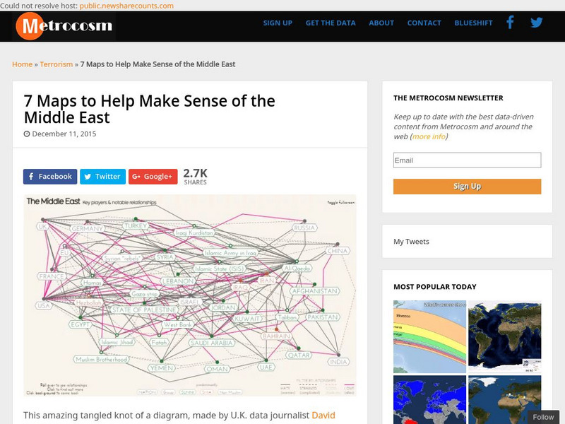
Metrocosm: 7 Maps to Help Make Sense of the Middle East
Keep up to date with the everchanging Middle East Region. The Middle East has been a tangled web of alliances since WWI. These maps attempt to make sense out of the this often confusing area. The 7 maps show the relationships among...
PBS
Wide Angle: Interactive Map: Middle East
An interactive map that shows the countries of the Middle East in 2003. Gives information such as population, government, and history about each country.
CBS
Cbs News: Middle East Countries
Discusses each country in the Middle East and how it is affected by the problems that are going on in the region. Click on the tiny map in the upper left-hand corner to access the list of countries.
Lizard Point Quizzes
Lizard Point: Middle East: Countries Quiz
Test your geography knowledge by taking this interactive quiz over the countries of the Middle East.
Curated OER
University of Texas: Map of Southern Asia
This political map shows the countries and capitals of the Middle East and South Asia as well as other countries in Asia.
Latimer Clarke Corporation
Atlapedia: World Maps/middle East
Learn the locations and countries in the Middle East from this political map. Click on the link at the top of the page to see a physical map of the same region. Clicking on the country's name will take you to information about that country.
Other
Owl & Mouse Educational Software: Middle East Map Puzzle
This site has a puzzle of the countries of the Middle East that you can play online.
Ducksters
Ducksters: Geography for Kids: Middle East
Investigate the countries and geography of the Middle East. Study the flags, maps, facts, exports, natural resources, economy, populations, and languages of the Middle East.
Ducksters
Ducksters: Geography Games: Map of the Middle East
Play this fun geography map game to learn about the locations of the countries of the Middle East.


