Curated OER
Asia and the South Pacific : Political Map
In this Asia and the South Pacific map learning exercise, students examine the boundaries of the nations in this region of the world. Students also note the location of capital cities as they are denoted by stars. Major bodies of water...
Curated OER
Canada Outline Map
In this Canada political map worksheet, students examine the province boundaries of the nation. The province names are labeled on the map.
Curated OER
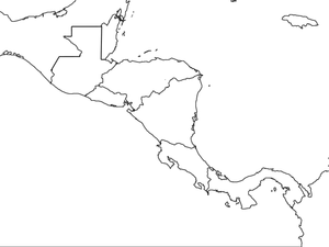
Central America Map wtih Country Borders
In this blank outline map worksheet, students explore the political boundaries of Central America and the nations there. This map may be used in a variety of classroom activities.
Curated OER
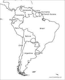
South America Outline Map
In this blank outline map activity, students explore the political boundaries of South America and the nations there. This map may be used in a variety of classroom activities. The map is labeled with the country names.
Curated OER
South America Outline Map
In this blank outline map worksheet, students explore the political boundaries of South America and the nations there. This map may be used in a variety of classroom activities. The location of the capital cities are denoted with...
Curated OER
Africa Outline Map
In this outline map activity, students discover and investigate the continent of Africa and the political boundaries of its nations. This blank outline map may be used for a variety of classroom activities.
Curated OER
Africa Outline Map: Labeled
In this Africa outline map worksheet, students explore the political boundaries of the continent of Africa the countries located there. Each of the nations is labeled on the map.
Curated OER
Historical Atlas
Sixth graders evaluate how revolutions have affected the world throughout history (i.e. boundaries of nations, culture, economics, etc...) through the research for and creation of a historical atlas for assigned countries.
Curated OER
Walking that Line
Students attempt to describe and use longitude and latitude. They will identify different countries, their neighbors, and borders around the world. Included in the lesson the students identify natural features that control the borders of...
Curated OER
Track Your Trip
Fourth graders are shown how to read a map and identify key cities, landmarks, rivers, state boundaries, and train routes. They solve basic mathematical problems. Students reivew the componets of a map legend. They are asked to find...
Curated OER
Scavenger Hunt
Students participate in a scavenger hunt to gather information on their governmental officials. Using the internet, they identify and discuss the various political boundaries to determine who their representative is. They complete a...
Curated OER
Waterbasins and Watersheds
Students define water basins and watersheds, then delineate the boundaries of their local water basin/shed using maps.
Curated OER
Personal Accounts of the Korean Civil War 1950-1953
Ninth graders evaluate primary source documents from the Korean Civil War to compare and contrast them to different countries. They identify the boundaries of the Korean Civil War and work in groups to investigate the story of a Korean...
Curated OER
Mississippi Under British Rule
Students construct appropriate maps to depict the following information: changes in European territorial claims as a result of the French and Indian War; boundaries of British East and West Florida; significant rivers and settlements of...
Curated OER
Ideas and Commodities Cross Cultural Regions
Students compare and contrast how commodities native to certain countries have impacted the economies of other nations. After gathering information regarding how commodities are grown and traded, students use their information to...
Curated OER
Translating Traditions
Students analyze art reflective of traditions and cultural heritage. In this art analysis lesson, students complete image based discussion.
Curated OER
Mapping the Middle East
Students examine how the countries of the Middle East were created. They explore the influence of various political and geographic factors in their creation. They list the things they should consider in deciding how to draw new borders...
Curated OER
Globe Skills Lesson 5
In this map skills worksheet, students read a text selection about locations during the American Revolution and then respond to 8 fill in the blank questions.
Curated OER
Lesson 2 Activity 2: In the Wake of Lewis and Clark
Students study the route of Meriwether Lewis and iam Clark's travels and the important events in their journey. They mark the sites on a map and then plan a trip along part of the route.
Curated OER
South American Cultures
Middle schoolers examine South American festivals. In this cultural diversity lesson, students research Spanish cultural festivals and determine their purpose. Middle schoolers write and conduct a survey about cultural festivals.
Curated OER
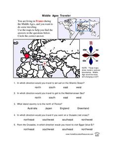
Middle Ages Traveler
In these Middle Ages worksheets, students use the maps to help them find the answers to the questions that help them understand the directions of north, south, east and west. Students also color another map of France according the...
Curated OER
Jazz in America
Students participate in a class discussion about jazz music, compare improvisation with regular conversion, listen to various jazz musicians and compare and contrast their individual sounds.
Odell Education
Building Evidence-Based Arguments: "Cuplae poena par esto: Let the punishment fit the crime."
Should a criminal's punishment match the crime? An argumentative writing plan explores this question as class members investigate a variety of mixed-medium sources by experts in the field, form evidence-based claims, and support them...
Desert Discoveries
The Sonoran Desert
Elementary schoolers study the geographic location of the Sonoran Desert. They pay close attention to the characteristics of the plants and animals found in this desert environment. The student handouts embedded in this plan are...


