Curated OER
The Vision Quest
Fourth graders explore lives of Chief Plenty Coups and Crow Indians, focusing specifically on tradition of Vision Quests. Students identify reasons for Vision Quests, and create presentation to share information found with classmates.
Curated OER
Council Grove: Site of the Hellgate Treaty
Pupils explore Native Americans and the migration of non native people to Montana. They investigate and interpret maps for information such as location of Indian reservations, transportation routes and important communities.
Curated OER
Sorting
Students explore how to sort and manage information. In this organization lesson plan students complete an activity on sorting.
Curated OER
Canada Arrives in a Splash of Color
Students investigate social and political issues surrounding founding of Canada and compare their relevance to Canada today, interpret art works representing Canada's past identity and compare that identity to how Canada is perceived...
Curated OER
The Landscape
Students create works of art that portray their connection to their environment, construct class sculptural landscape, record changes to their environment since their grandparents' time, and paint one referenced art work from new...
Curated OER
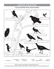
Shadow Know-How
For this science worksheet, students identify 11 bird species by their shadows or silhouettes. Students write the name of the bird in the box under the shadow. Answers are provided upside down at the bottom of the page.
Curated OER
Note Taking: Research on the Middle Ages
Students explore the Middle Ages. In this research skills instructional activity, students research selected Internet sources regarding the Middle Ages and use the provided graphic organizers to take notes regarding the information they...
Curated OER
Through Time: Change in Sedona
Pupils locate events on a timeline of Sedona, Arizona and describe human and physical characteristics of the city. In this Sedona lesson plan, students locate the city on a map and listen to stories about Sedona.
Curated OER
Using Triangulation to Locate Meteorites from Witnessed Falls
Pupils participate in a mock investigation in which they must interview and record data given by 3 people ("witnesses") in an effort to triangulate the location of a meteorite.
Curated OER
Public Goods and Common Resources
In this economics worksheet, learners respond to 3 short answer questions and complete a graphic organizer about public goods and common resources.
Curated OER
If These Walls Could Talk: Seeing a Culture Through Human Features
Students read Talking Walls and discuss the walls presented and their importance to the culture. In this geography lesson, students locate and label each country/continent discussed in the book on a world map. Students take a walk and...
Curated OER
What's In The Forest?
Students examine forest food chains and create a forest habitat in the classroom. They are introduced to the concept of interdependence in Nature. They define a simple forest food chain and develop inquiry process skills.
Curated OER
The IMF in Action: What Does the IMF Do?
Students use newspapers and the internet to discover what the IMF does. They work together in groups to brainstorm occupations which need another language to be spoken. They also examine data related to trading among countries.
Curated OER
Planning a Bluegrass Festival
Students explain how bluegrass music gained popularity across the country and around the world. They describe the roles of artists, patrons and music organizations in producing bluegrass music festivals. In addition, they
use a variety...
Curated OER
Design Your Own Suburb
Students view and discuss urban and suburban scenes; and list the features of their ideal town and discuss whether these features can be found in cities and suburbs. They draw mental maps of a city and a suburb and brainstorm and list...
Curated OER
The Industrial Revolution and Women
Students learn about inventions of the Industrial Revolution and their impact on life. In this Industrial Revolution lesson, students look at how the Industrial Revolution changed the work experience from farms to factories. They tell...
Curated OER
MOBILITY, Bike Rack Remix
Students examine how riding a bike can impact the environment and cut down on carbon emissions. In this environmental lesson students design a bike rack that is made from recycled material.
Curated OER
Lost Creek- Sacred Landscapes
Eighth graders engage in the discovery of the meaning of Sacred Landscapes. The religious concept is researched for its impact upon the practices of Native Americans and the geographical regions. They write reflection papers upon the...
Curated OER
Lone Pine- Cultural Fire Management
Fourth graders investigate the concept of fire and how it was used by the Native Americans. The lesson has sufficient background information for the teacher to establish historical context. Students summarize the nine uses for fire to...
Curated OER
Loss of Wetlands: Subsidence
Students observe subsidence and the effect it has on wetlands with a classroom demonstration. They think about the impact of global warming and the sea level and how it affects the marsh.
Curated OER
Civil Rights Heroes
Students explore the actions of people involved in the Civil Rights Movement. They explore the reasons for the movement and its successes and failures, and explain the sacrifices made by those who participated in the movement.
Curated OER
Out of the City and Into the Soup
Students examine the issue of air pollution. They read and analyze an article, evaluate the responses of state and federal officials to the problem, conduct Internet research, and write a letter to their senator and congressman.
Curated OER
Demography and Services of Fairfax County, Virginia
Twelfth graders are introduced to the demographics and services of Fairfax County, Virginia. In groups, they identify programs and services that should be supported by tax dollars and presnt them to the class in a PowerPoint presentation.
Curated OER
What Are The Characteristics of Your Neighborhood?
Young scholars make a mental map of their neighborhood. Using a software program, they make an aerial and digital map of their school and locate their school on given maps. In groups, they calculate the distances to various locations and...


