New York Times
New York Times: Crossword Puzzle: The Fifty States
The New York Times Learning Network presents an online crossword puzzle that you can print or play online. This one is on The Fifty States. Subject matter may be a bit deep for an elementary student to work on independently.
CRW Flags
Flags of the World: Clickable Map of the United States
Includes both printable images and fascinating trivia behind the flag of each state. It includes alternate flags used in the past.
PBS
Pbs Learning Media: 50 States Part 2 Lesson Plan
In this lesson, students combine psychomotor skills and geography as they travel from Montana to Wyoming. As students travel from state to state, they learn regional facts and state capitals. Students perform physical tasks highlighting...
University of Minnesota
U Mn: Immigrants & Cities: Mapping Ethnic Enclaves in Early 20th Century Us
This resource couples a visual and descriptive map of urban ethnic enclaves with an oral interview by an immigrant growing up in New York City. Its goal is to provide different ways of "mapping" or understanding life for immigrants...
Curated OER
Educational Technology Clearinghouse: Maps Etc: Relief of New York, 1872
A relief map from 1872 of New York State showing the mountain systems, valleys, lakes, and rivers of the area.
Curated OER
Etc: Maps Etc: Congressional Districts of New York, 1903
A map outlining the congressional districts of New York State in 1903.
Houghton Mifflin Harcourt
Holt, Rinehart and Winston: Estados Unidos De America: Nueva York
This site has a map of New York in Spanish, with informational data also presented in Spanish about the state of New York. Land mass, population, elevation, industry, agriculture,minerals and resources are among the topics addressed....
New York Times
New York Times: Action in Iraq, April 9
A map that shows what portions of Baghdad were taken first by American soldiers. The map allows the user to zoom in and look at different descriptions of key parts of the city that the United States first brought under control. (10 April...
Curated OER
Etc: The Revolution in New England States, 1774 1783
A map of America's New England states during the time of the American Revolution, including Maine, New Hampshire (with Vermont), Massachusetts, Rhode Island, Connecticut, and Long Island. The map shows major cities, towns, forts, battle...
Other
The Erie Canal: Low Bridge, Everybody Down [Pdf]
The learning activity examines how the Erie Canal affected New York State's development.
Library of Congress
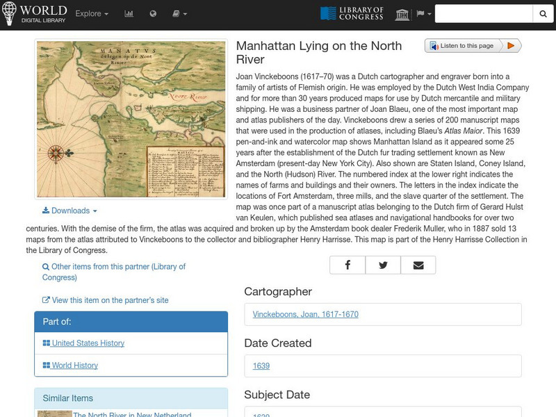
World Digital Library: Manhattan Lying on the North River
A historic map of Manhattan created by cartographer Joan Vinckeboons around 1639 for the Dutch West India Company. A feature on the page allows the visitor to listen to and read the accompanying descriptive text in seven different...
Curated OER
Educational Technology Clearinghouse: Maps Etc: Albany and Vicinity, 1872
A map from 1872 of the vicinity of Albany New York, showing neighboring towns and the Hudson and Mohawk rivers. Albany, now the capital of the state of New York, is situated on the west bank of the Hudson River, 145 miles north from New...
Curated OER
Educational Technology Clearinghouse: Maps Etc: Lands of the Duke of York, 1664
Areas of the northeastern United States, granted by English King Charles II to his brother, the Duke of York, after seizing them from the Dutch. These lands were thus renamed New York.
Curated OER
Educational Technology Clearinghouse: Maps Etc: United States, 1821
A map of the United States and territories in 1821 after the Missouri Compromise, showing the Free States and territories, the Slave States and territories, and the transitional territories at the time. The map is color-coded to show the...
Curated OER
Etc: Maps Etc: Comparative Areas of the United States and Other Countries, 1872
A map from 1872 of the United States used to illustrate the comparative area sizes of the states to other countries in the world. The map shows state and territory boundaries at the time (Dakota, Montana, Washington, Idaho, Wyoming,...
Curated OER
Etc: Maps Etc: The States and Their Land Claims at Close of Revolution, 1783
A map of the United States at the close of the American Revolutionary War showing the newly formed States, and their claims to the lands west of the Allegheny Mountains to the Mississippi River. The map shows the territories jointly...
Curated OER
Etc: American Revolution in the the Middle States, 1774 1783
A map of America's middle states during the time of the American Revolution, including New York, Pennsylvania, New Jersey, Delaware, Maryland, and part of Virginia and North Carolina. The map shows major cities, towns, forts, battle...
Curated OER
Etc: The Campaigns in the Middle States, 1777 1778
A map of parts of New York, New Jersey, Pennsylvania, and Maryland involved in the early years of the American Revolutionary War. The map shows cities and towns, rivers and terrain, forts, and battle sites of the region, including Crown...
Curated OER
Etc: Maps Etc: The United States at the Close of the Revolution, 1783
A map of the United States at the close of the American Revolutionary War (1783) showing the newly formed States, and their claims to the lands west of the Allegheny Mountains to the Mississippi River. The map notes that the territory...
Curated OER
Etc: Maps Etc: Mexico, Central America, and the West Indies, 1898
A map from 1898 of Mexico, Central America and the West Indies. The map includes an inset map of Cuba and the Isthmus of Nicaragua. "The surface of the Rocky Mountain highland in Mexico is quite similar to that of the great plateau...
Curated OER
Etc: Maps Etc: House Vote on the Wilson Tariff, 1894
A map of the United States showing the results of the House vote on the Wilson Tariff Bill (also known as the Wilson-Gorman Tariff Act or the Revenue Act), August 13, 1894. The proposed tariff was a reduction of the earlier McKinley...
Curated OER
Etc: Maps Etc: Land Claims of the Colonies, 1783
A map of eastern North America showing the land claims of the thirteen original states in 1783, from the Atlantic coast west to the Mississippi River. The map notes that New York claimed all the lands west of the Alleghany mountains....
Curated OER
Etc: Maps Etc: House Vote on the Mc Kinley Tariff, 1890
A map of the United States showing the results of the House vote on the McKinley Tariff Bill, 1890. The proposed tariff was on imported manufactured goods, and while protecting the manufacturing industry, placed hardships on the...


