Curated OER
Map Skills
In this map skills worksheet, students research and label the states in Australia and add in the major cities, oceans and seas.
Curated OER
Mapping Japan
For this Japan worksheet, students label cities, islands, seas, and more. Students label 11 different areas of the country of Japan.
Curated OER
Where in the World? Oceans & Continents
In this geography worksheet, students answer 6 questions using a coded map as a reference, then students identify labeled geographic features.
Curated OER
Mapping Brazil
In this Brazil activity, students label cities, oceans, and surrounding countries around Brazil. Students label and color 10 places.
Curated OER
Moon Features Activity
In this moon worksheet, students answer questions about the lunar surface and identify the features of the moon on a moon map. They include craters, bays, mountains, seas, oceans and craters.
Curated OER
North American Rivers Map Quiz
In this online interactive geography quiz worksheet, students examine the map that includes 13 rivers in North America. Students match the names of the rivers to the appropriate places on the map.
Curated OER
Mapping the United States
In this map of the United States worksheet, students label mountains, surrounding countries, oceans, and more. Students complete 12 tasks.
Curated OER
Finding Ocean Depth
How to oceanographers measure the sea's depth? Your scientists will step into their shoes in this application worksheet, first reading about how the speed of sound and a simple formula give scientists a depth estimation. Learners...
Curated OER
Asia Rivers Map Quiz
For this online interactive geography quiz worksheet, learners examine the map that includes 18 Asian rivers. Students match the names of the rivers to the appropriate locations on the interactive map.
Curated OER
Europe Rivers Map Quiz
For this online interactive geography quiz worksheet, students examine the map that includes 14 European rivers. Students match the names of the rivers to the appropriate locations on the interactive map.
Curriculum Corner
Earth Day Book
This Earth Day, celebrate our beautiful planet with an activity book that challenges scholars to show off their map skills, complete a crossword puzzle, write acrostic poems, alphabetize, and reflect on their personal Earth-friendly habits.
Curated OER
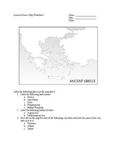
Ancient Greece Map Worksheet
Since the beginning of time, geography has shaped the development of human civilization, and ancient Greece is no exception. This activity supports young historians with exploring this relationship as they first identify key land masses,...
Curated OER
Regents High School Examination: Physical Setting Earth Science 2006
Test your class on earth science with this extensive resource. This test, created by The University of the State of New York Regents, is made up of 50 multiple choice questions and 32 short answer questions that cover the branches of...
Curated OER
World Map Labels
In this geography skills instructional activity, students identify the countries and bodies of water labelled on the maps of the world, Africa, Asia, Canada, Europe, the Caribbean, the Middle East, North America, Australia, and South...
Curated OER
Atlantic Ocean Map Quiz
In this online interactive geography quiz worksheet, students respond to 7 identification questions regarding the Atlantic Ocean.
Curated OER
Mapping Australia
For this mapping Australia worksheet, students locate and label various features and places on a blank map, 10 total. A reference web site is given for additional activities.
Curated OER
U.S. Geography for Children
In this U.S. map activity activity, students observe maps of the continental United States, Hawaii, and Alaska, locate and label landforms and bodies of water, and create symbols for natural resources and places of interest. Students...
Curated OER
Europe Lakes Map Quiz
In this online interactive geography quiz worksheet, students respond to 10 identification questions about major lakes located in Europe.
Curated OER
Ancient Middle East Geography
As part of a study of ancient Middle East geography, kids locate seas, rivers, regions, and cities on a map of the region.
Curated OER
How Much Ocean?
In this ocean activity, students are given a map of the world and they predict the amount of water that covers the Earth's surface. They count the total number of squares on the given map that represent the water and they land and they...
Geography 360°
Introducing Europe
Provide your learners with a comprehensive introduction to Europe with this great set of worksheets. Map activities include matching European countries to their capitals and places on a political map, as well as exploring different...
Super Teacher Worksheets
My Explorer Report
This is the perfect resource to accompany your class project on famous explorers! Learners detail basic information about their chosen explorer, his/her main events of exploration and means of transportation, and finally, illustrate the...
Curated OER
Breaking News English: Map Shows the Chinese Discovered America
In this English worksheet, students read "Map Shows the Chinese Discovered America," and then respond to 47 fill in the blank, 7 short answer, 20 matching, and 8 true or false questions about the selection.
Curated OER
What is Climate?
In this weather learning exercise, students identify and explain the factors that can affect the climate in each area of the illustrated map. Then they describe the various effects of these factors, such as air pressure systems and the...


