Curated OER
What's Its Slope
Young scholars identify the slope of a lines.In this algebra lesson, students define the meaning of slope and write an equation given the slope. They graph linear functions using the slope and y-intercept.
Curated OER
Cranes, Crosswalks, and Big Gulps
Learners watch a video and answer questions based on wildlife jobs. In this wildlife lesson plan, students learn that biologists don't just play with animals but that there is a lot of study involved.
Curated OER
Spirituals
Fourth graders realize the significance in the Negro spirituals concerning the Underground Railroad. They choose a position, either for helping slaves or ignoring the slaves. They describe, in a paragraph, their position.
Curated OER
Indoors, Outdoors
In this buildings worksheet, students answer 16 questions about buildings. This worksheet is to be completed online because it provides links to various pages, which contain pictures needed to answer the questions.
Curated OER
ACE Expert English Homework- July 12, 2006
In this ESL worksheet, students complete 8 pages of exercises designed for ELL students from Thailand. Activities included are writing sentences, completing dialogs, and matching phrases and pictures.
Curated OER
"The Outsiders" by S.E. Hinton
Students estimate the distance in miles between Tulsa, Oklahoma and Manhattan, Kansas. They gather and graph data on gangs in both areas.
Curated OER
Trade and Travel on the Overland Trails
Students compare and contrast trade routes. In this trade route instructional activity, students explore the Oregon Trail and the Santa Fe trail. Students compare and contrast the purposes for these trails.
Curated OER
Lines and Shapes
First graders identify different kinds of lines found in common shapes. They discover ways in which an artist utilizes lines in a painting.
Curated OER
That's Not Fair!! Human Rights Violations during the 1800s
Students explore the migration of African Americans into the Hoosier area. They develop a time line showing migration patterns in Indiana and explore reasons for African Americans to settle and/or travel through Indiana.
Curated OER
Patterns of Settlement in Early Alabama
Fourth graders study the settlement of Alabama. They collect data from the U.S. census website and answer questions regarding settlement patterns in the counties of Alabama in 1820. They write a paagraph describing where they would have...
Curated OER
Human Features of Our Community
Students investigate the human factors that create a community. They conduct research using a variety of sources. Students then create dioramas that depict a typical scene found in a community.
Curated OER
Spirituals
Fourth graders examine the significance in the Negro spirituals concerning the Underground Railroad. They explore the cultural, geographical, historical, physical, and Psychological aspects involved in the Underground Railroad
Curated OER
Tickling the Brain
Students improvise scenes which relate to the plot of Much Ado About Nothing.
Curated OER
Mound Cities
Students learn about Mound Cities and how they both started and stopped. In this Mound instructional activity students explore how Mound Cities did not succeed and why. Students dig deeper then the instructional activity as they discuss...
Enchanted Learning
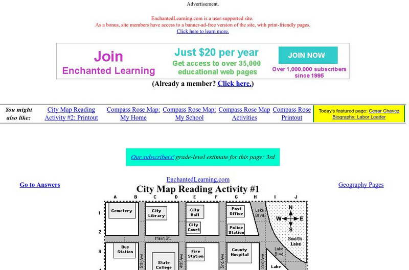
Enchanted Learning: City Map Reading Activity #1
Using a diagram of a labeled map, students follow the directions given to find a certain location.
Alabama Learning Exchange
Alex: Character Web With Dust Tracks on a Road
Students will read "The Inside Search," from Dust Tracks on a Road with a partner creating a character web.
Texas State Library and Archives Commission
Texas State Library and Archives Commission: Hard Road to Texas 1836 1845: Lamar and the Rise of Texas Nationalism
The pride Texans feel about their state "can be traced to roots in the Republic of Texas era." Read about this era and the president who wanted Texas to stand alone and not become part of the U.S., and check out a map and other primary...
Texas State Library and Archives Commission
Texas State Library and Archives Commission: Hard Road to Texas 1836 1845: Texas Breaks Away Alone in the Wilderness
Read about the effects of the Texas Revolution. How did Americans react? How did the annexation process begin, and what roadblocks were there? Find the answers to these questions, and check out a map of Texas from 1836 and other primary...
Texas State Library and Archives Commission
Texas State Library and Archives Commission: Hard Road to Texas 1836 1845: Aftermath the Reckoning
What happened in the 15 years that followed the annexation of Texas? How did the Mexican War end? Read this article to learn about the aftermath of the annexation, and check out primary documents--a "moral map" of the United States and a...
Curated OER
Educational Technology Clearinghouse: Maps Etc: Surrey and Sussex, 1908
A detailed travel map of southern England from 1908, showing portions of Surry and Sussex (East and West) counties. The map shows first class and secondary roads, railways, cities, towns, rivers, coastal and terrain features of the area....
Curated OER
Educational Technology Clearinghouse: Maps Etc: Buckingham and Hertford, 1908
A detailed travel map of England in 1908, showing portions of counties Bedford, Buckingham, Hertford, Essex, and Middlesex. The map shows first class and secondary roads, railways, cities, towns, rivers, and terrain features of the area....


