Little 10 Robot
Geography Drive USA™
A trivia-style virtual road trip in which the player's car is moved from state to state as questions are correctly answered. Ideally, a player would learn about different states by reading the simple brochures available in the...
Curated OER
Map the Civil War
Students explore the Civil War through original maps. In this mapping activity, students calculate distance and show it on an original map. Students examine the type of landscape and its landmarks and draw symbols on the map.
Center for History Education
Road to Revolution: How did Actions and Responses Lead to an Independent United States?
Using primary sources, maps, and an interactive M&M game, young historians examine the American revolution as if they were detectives trying to solve a crime. Resource includes graphic organizers and a final writing prompt to aid...
Curated OER
Map Reading in the 21st Century
Students interact with MapPoint tools to view maps of the past and the present in multiple ways. They participate in mini-lessons aimed at locating certain points of interest or famous routes taken in history.
Curated OER
Westward Expansion : Mapping
Fifth graders travel along exploring the expeditions of John F. Fremont. For this Westward expansion lesson, 5th graders gain understanding of the events that shaped the west through the use of maps. Students use mapping skills to...
Curated OER
Planning a Road Trip!
Students generate plans for a fictitious road trip. In this time management activity, students investigate the most effective way to travel the country arriving at specific cities. Students create their plans based on time...
Curated OER
Topographic Maps
In this topographic map worksheet, students learn how to read a topographic map and create a topographic map of their own using clay or Play-Doh. Students include contour lines by layering the clay. Students answer 6 questions about...
Curated OER
Mapping School Grounds
Students map and analyze the natural and cultural environment of the school grounds. In small groups, they sketch the natural and cultural features of each side of the school building, create a map, participate in a class discussion,...
Curated OER
Paint My Counties: Map Coloring the Counties of Arizona
Fourth graders identify the counties of Arizona. In this social studies lesson, 4th graders color a county map of Arizona using the fewest number of colors possible. Students write a persuasive paragraph.
Curated OER
Designing a Hiking Trail
Put your students' map skills to the test with this engaging cross-curricular project. Given the task of developing new hiking trails for their local community, young cartographers must map out beginner and intermediate...
Curated OER
Geographical Skills-- Map Scale
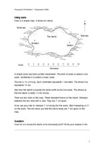
In this maps instructional activity, students study a simple map and the scale in kilometres. Students read the directions and answer one question. Students then look at a sketch map of a town and answer 2 questions. Students also read...
Curated OER
Learning to Read a Regional Map
Students locate the local community, surrounding communities and major geographic features of the SE Utah and the Four-Corners region on a map, after receiving direct instruction.
Curated OER
Map of Kellyburi
In this map worksheet, 6th graders use a map to label 12 locations, answer 6 directional questions, write the answer for 17 general information questions, select the word for 10 sentences and read 25 English words for Thai animal names.
Curated OER
Scale Skills
For this mapping skills worksheet, students read an excerpt that describes three different types of scales and how to calculate distance on a map. They respond to two short answer questions using the map provided on the sheet and to...
Curated OER
Teen America Travels New England
Students simulate the role of a travel agent to understand how to read and use road maps. They plan a bus trip through New England for a group of travelers that includes, bus travel, meals and attractions. They plan the distance that...
Curated OER
Test Your Reading Skills - Understanding Maps 2
In this map reading worksheet, learners will use their answers from p.62 (another worksheet) and the map of Melton Park on p. 61 (another worksheet) to fill in the missing words on the worksheet.
Curated OER
Discovering New Mexico
Seventh graders discuss the elements of maps and using basic linear measurement. They calculate the distance between the cities and create a simulated journey around New Mexico using a road map. They write out the directions for their...
Curated OER
Draw an Inch, Walk a Mile
Students work in small groups to solve the problems presented. The main project, mapping the classroom, use these discussions to collaborate in creating a tangible demonstration of their understanding.
K20 LEARN
Let Us Start The Lettuce Club (Or Not): Writing A Thesis Statement
Let us be frank! Writers learn that crafting a thesis statement is not that difficult if one peals back the layers. After watching several videos about the elements of a thesis, class members read the article "Lettuce Club helps students...
Curated OER
Tooling Around Arizona: Reading Arizona Maps
Students study geography. For this Arizona maps lesson, students develop their map reading skills. They have class discussions and work independently with various copies of Arizona maps to practice those skills. This lesson mentions...
Curated OER
Take a Hike
In this geography skills instructional activity, students respond to 9 questions that require them to read topographic maps and interpret them. The topographic maps are not included.
Curated OER
Grades 6-8 Lesson Plan - Cities as Transportation Centers
Students examine maps of the 1800's and 1900's. In this geography skills lesson, students collaborate to read core maps and identify transportation centers and travel networks.
Curated OER
A Shuttle's Eye View
Students explore the goals of the Shuttle Radar Topography Mission as a springboard to exploring the topographical features of their own state or region. They synthesize their understanding of landforms and topography by mapping their...
Curated OER
Star Maps and iPads: Explore The World Above
Use these helpful stargazing tips and tools to enjoy the night sky this summer.


