Curated OER
Map of Africa
Using a completed map (not provided), pupils will use this map to fill in the geographic features of Africa. An appropriate map can be printed using the Internet and placed under a document camera for the class to reference.
Curated OER
The Barbarian Invasions of the Roman Empire
Fifteen different locations to map and correctly label. Use the provided list to show major areas of Barbarian invasions occurring during the Roman Empire.
Curated OER
The Expansion of Islam to 750
Track the expansion of Islam throughout the Mediterranean and Near East. Locate and label 17 different areas that adopted the tenets of Islam.
Curated OER
The Spread of Printing
Document the spread of printing, which occurred in the 1500s. Use the provided list of water ways, countries, and cities to label specified locations on the map.
Curated OER
The Netherlands: map
Use the provided list to label a map of Europe and the Netherlands. There are 77 locations to label. You have to know your stuff to fill out this challenging map.
Curated OER
European Language Groups, 1850
Document the linguistic diversity and major language groups common to Europe in 1850. A map and a list of regions, countries, and water ways is provided.
Curated OER
The Crimean War
Use the list of cities, countries, and water ways to correctly label a map of the regions associated with the Crimean War. There are approximately 20 locations to locate and identify.
Curated OER
The Soviet Union: Flashcards
Kids can use these question-style flashcards to practice memorizing states and capitals. There are 10 cards, each includes a question and answer related to the states and capitals of the Soviet Union.
Curated OER
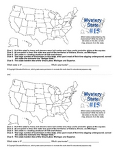
Mystery State #15
Do you know the name of the Badger State? Using five fantastic clues, your super sleuths will determine the name of mystery state number 15. A wonderful way to warm up the class!
Curated OER
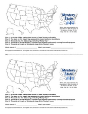
Mystery State # 44
Problem solving comes in all shapes and sizes. Here is a short problem-solving activity that requires learners to use five clues to determine the name of mystery state number 44. Do you know from which state Elvis hails?
Curated OER
Mystery State #2
Which is the mystery state for today? Using five super clues, your class will work to uncover which state is being described. They'll have no problem remembering facts about Nevada after this fun warm-up activity.
Curated OER
War of 1812: Map and Label
Map test! Hand out this map of the East Coast of the United States and let learners mark each of the nine sites listed. They'll be making a map that shows the battle sites and areas involved in the War of 1812. Great as a test or as a...
California Academy of Science
Guess That Spice
From medical treatments to cooking, people have been using herbs and spices for thousands of years. Perform a blind smell test of household herbs and spices to engage students in learning about ancient spice trading. Research the history...
Curated OER
Social Studies and Children's Literature
Young scholars write a journal in response to literature. The story that is read is about prairies. The subject of prairies becomes an object for research. The culminating activity is the making of a map where prairies exist in the...
Curated OER
World Geography Quiz
In this world geography instructional activity, students answer several questions based on world geography and landmarks. Students answer 10 multiple choice questions.
Curated OER
Social Studies For Elementary School
Fourth graders become familar with maps and work in groups to get an overview of what Europe is like. The real assignment is in the form of students creating their own trip if it could really be taken.
Curated OER
How Many Ways Can You Say Merry Christmas?
Students create a multicultural holiday bulletin board map! students research and study saying Merry Christmas in different languages. They correctly locate the countries on a world map.
Curated OER
The Desert Alphabet Book
Learners explore world geography by researching a science book with their classmates. In this desert identification lesson, students utilize a U.S. map to locate the geographical locations of deserts. Learners create an oral report based...
Curated OER
GANDHI'S INDIA
Young scholars describe key events in the life of Gandhi. They determine why knowledge of geography is necessary to understand the history of the people in a place or region. They write a summary of how the events in Gandhi's life,...
Curated OER
African Safari
Seventh graders examine different countries in Africa to research. They choose one to concentrate their research on using the five themes of geography. They design a multimedia presentation that will make up the African safari.
Curated OER
The Nile: A Gift to Egypt
Sixth graders discover the Egyptian culture. For this Nile River lesson, 6th graders examine why the river is so important to Egypt.Students study the religions, geography and the people of Egypt. Students create an exhibit where they...
Curated OER
Play Doh Map of Your State
Students create a state map using Playdoh. In this hands-on state geography activity, students work in groups to form a three-dimensional map of their state using Playdoh made at home following a (given) recipe. Students use four colors...
Curated OER
A Tough Nut to Crack
Sixth graders explore agriculture by examining world geography. For this pecan cultivation lesson, 6th graders identify the history of the famous nut and the impact it has on the U.S. economy, diet and human body. Students define...
Curated OER
The High and the Flighty
Students study women aviators and act out a talk show-style interview with one of them. They plot Amelia Earhart's flights on a map.


