Curated OER
Globe Skills Lesson 7 The Transcontinental Railroad
Students explore the Transcontinental Railroad. In this geography skills lesson, students use map skills in order to locate legs of the Transcontinental Railroad on globes.
Curated OER
Globe Skills Lesson 6 The Louisiana Purchase
Students explore the Louisiana Purchase territory. In this geography skills lesson, students use map skills in order to plot and note latitude and longitude, measure scale distance, and locate landforms that were part of the Louisiana...
Curated OER
Globe Skills Lesson 11The Vietnam War
Students develop their globe and map skills, In this geography lesson, students examine the Vietnam War as they complete an activity that requires them to plot latitude and longitude.
Curated OER
Charting Neptune's Realm:
Students explore how to construct and interpret maps and globes and find information about people, places, regions, and environments.
Theodore Roosevelt Association
Roosevelt's Legacy: Conservation
The legacy of Theodore Roosevelt carries through modern American politics, economics, foreign policy, and society. But his proudest and most profound efforts were in the world of conservation, and in preserving the natural beauty of...
Syracuse University
Erie Canal
While canals are not the way to travel today, in the first half of the nineteenth century, they were sometimes the best way to move goods and people. Scholars examine primary sources, including maps and pictures, to investigate the role...
Channel Islands Film
Arlington Springs Man: Lesson Plan 4
West of the West's documentary Arlington Springs Man introduces viewers to the remarkable finds on Santa Rosa Island. Archaeologist have discovered on this small island that is part of the Channel island chain, human and pygmy mammoth...
Tidewater Community College
Assignment: The “Big Mac” Index
Young economists learn about the method of predicting changes in the exchange rate with Big Macs in an instructional video. After an understanding the index, learners write a post on a discussion board and respond to class members' posts...
National Endowment for the Humanities
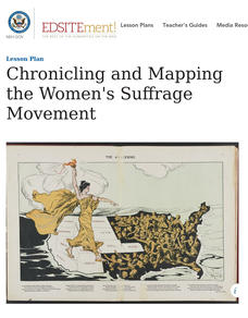
Chronicling and Mapping the Women's Suffrage Movement
While women's suffrage is often believed to be the result of a single constitutional amendment, the effort of women to secure the vote spanned decades and continents. Using primary sources in online archives, class members explore the...
University of Pennsylvania
Using Political Postcards to Teach a Revolution of Political Thought
Discuss how political postcards affected everyday people's thoughts and beliefs. Pupils continue a unit on the Dreyfus Affair as they engage in class discussion, watch a video, view a PowerPoint presentation, and fill out worksheets to...
University of Pennsylvania
From the Dreyfus Affair to the World Today
Historical events do not occur in a vacuum. Such is the case of the Dreyfus Affair, where the connection between Captain Alfred Dreyfus, Emile Zola, and Hannah Arendt is fused by the events of the early 20th century. The informative...
Curated OER
Maps
Maps, globes, and computer software aid young explorers as they locate state capitols, major cities, geographic features, and attractions for states they are researching. They then use desktop publishing software to create a map to share...
Curated OER
China Quest
Read and research information on China. Young researchers complete a knowledge hunt about China then locate and describe each location using directional words. They recognize the word meaning through context clues and application practice.
Smithsonian Institution
A Ticket to Philly—In 1769: Thinking about Cities, Then and Now
While cities had only a small fraction of the population in colonial America, they played a significant role in pre-revolutionary years, and this was certainly true for the largest city in the North American colonies: Philadelphia. Your...
Global Oneness Project
The Value of Ancient Traditions
Imagine having to give up cell phones, computers, and TV? What would be lost? What gained? An examination of the Drokpa, a nomadic people who live in the grasslands of Tibet, provides class members an opportunity to consider how access...
Curated OER
Introduction to Maps
Learners develop their map skills. In this geography lesson, students participate in an activity that requires them to survey their social studies book in order to find different types of maps and purposes for their uses.
Curated OER
Teaching Elementary School Social Studies
Students identify possible social studies themes that can come from the video, "Voyage of Discovery". They list the five themes of geography. They develop elementary-level interdisciplinary unit plans for social study content. They...
Curated OER
FUN WITH MAPS
Fifth graders learn map skills by showing the routes they travel from home to school and using that data to practice map reading and interpreting geographical information.
Curated OER
Map Studies
Students study maps and use web based activities to develop their mapping skills. For this mapping skills lesson, students use the internet to define cartography they make a list of information regarding a typical road map and explain...
Curated OER
Opening Doors to Social Studies with Children's Literature: The Desert Alphabet Book
Pupils explore the geography of the United States. In this social studies lesson, students identify the major deserts on a map of the United States.
Curated OER
Topographic Maps
Students complete a worksheet about topographic mapping. In this map skills lesson, students examine the features and discuss the uses for topographic maps.
Curated OER
Incorporating Literature into Social Studies Teaching and Learning
Students engage in a study of incorporating literature into the Social Studies classroom. They review a variety of literature sources and then create a bulletin board with the information. Then students practice using the Reader's...
Curated OER
My World
Young scholars study maps. In this social studies lesson, students draw a map of either their room at home or the route they take to school. Young scholars label items on their maps.
Curated OER
We're on the Map!
Students identify a variety of topographic map symbols. They make generalizations about an unidentified community by reading and interpreting map symbols.


