Curated OER
Canada Outline Map: Labeled
In this blank outline map learning exercise, students study the political boundaries of the North American country of Canada as well as those of the provinces located there. This map is labeled.
Curated OER
Mexico Map
For this blank outline map worksheet, students study the political boundaries of the North American country of Mexico. This map may be used in a variety of classroom activities.
Curated OER
Mexico and Central America Map
In this outline map activity, students study the political boundaries of Mexico and the Central American countries. This map is labeled with the country names.
Curated OER
Canada Outline Map
In this blank outline map worksheet, students study the political boundaries of the North American country of Canada as well as those of the provinces located there.
Curated OER
Canada Outline Map
For this blank outline map worksheet, students study the political boundaries of the North American country Canada as well as those of the provinces located there. The capital cities of the provinces are listed.
Curated OER
Canada Outline Map
In this blank outline map worksheet, students study the political boundaries of the North American country of Canada as well as those of the provinces located there.
Curated OER
Canada Outline Map
In this blank outline map worksheet, students study the political boundaries of the North American country of Canada as well as those of the provinces located there.
Curated OER
Mexico Map
In this blank outline map worksheet, students study the political boundaries of the North American country of Mexico. The capital cities of each state are denoted with stars.
Curated OER
Mexico and Central America Map
In this blank outline map worksheet, students study the political boundaries of Mexico and Central America. Each of the counties is labeled and the capital cities are starred.
Curated OER
South American Outline Map
In this blank outline map instructional activity, students study the political boundaries of the continent of North America and those of the countries located there.
Curated OER
Europe Outline Map (Labled)
In this blank outline map instructional activity, learners study the political boundaries of the labeled European nations.
Curated OER
Africa Map Spatial Analysis
In this map skills worksheet, students complete a graphic organizer that requires them to examine what is represented on different types of maps of Africa.
Curated OER
Compass Rose
Keep it simple and visual when practicing directions using this compass rose labeling worksheet. Learners fill in the compass themselves, using cardinal and intermediate direction abbreviations. North is done for them. Consider using...
Eastconn
Learning to Analyze Political Cartoons with Lincoln as a Case Study
Discover the five main elements political cartoonists use—symbolism, captioning and labels, analogy, irony, and exaggeration—to convey their point of view.
Curated OER
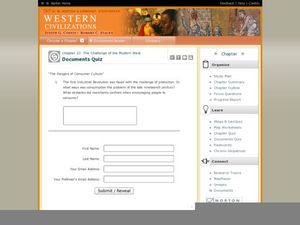
Western Civilizations, Chapter 23: Modern Industry and Mass Politics, 1870-1914
Looking for an interactive way to supplement your western civilization course? Check out this comprehensive website, designed to accompany the Western Civilizations text (although it is valuable independently). Scholars investigate...
Curated OER
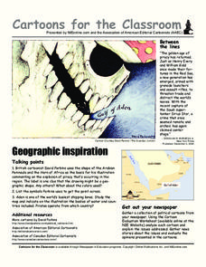
Cartoons for the Classroom: Geographic Inspiration
A wonderfully graphic cartoon entices learners to read more about issues near the Arabian Peninsula. They will use the provided cartoon and critical thinking question to practice building their analytical and critical thinking skills....
Curated OER
States and Capitals - Lesson 4 - U.S. Political Map
In this U.S. state capitals worksheet, learners identify the capital cities of the 50 states using the latitude and longitude coordinates provided.
Curated OER
Ancient Middle East Geography
As part of a study of ancient Middle East geography, kids locate seas, rivers, regions, and cities on a map of the region.
Curated OER
The Expansion of Islam to 750
Track the expansion of Islam throughout the Mediterranean and Near East. Locate and label 17 different areas that adopted the tenets of Islam.
Curated OER
Telling Direction - Compass Rose
Keep it simple when practicing directions using this compass rose labeling worksheet. Learners read a brief text describing the cardinal and intermediate directions, then fill in the compass themselves. They can get immediate feedback...
Curated OER
North America Outline Map
In this blank North America outline map worksheet, students study the political boundaries of the continent. This outline map may be used for a variety of geographic activities.
Curated OER
U.S. Geography: California
In this map skills about the state of California worksheet, students locate and label specific places and areas and create a map key and symbolize the economy and areas of personal interest. Students answer 5 questions.
Curated OER
U.S. Geography for Children: The Northeast
In this map skills of the northeastern United States worksheet, students observe an outline map, locate and label the states, and designated landforms and bodies of water; and create symbols and a map key for sources of economy and other...
Curated OER
U.S. Geography for Children: State Capitals
For this United States map skills worksheet, students locate and label specified states and their capitals, and create icons and a map key to show something for each state that is famous. Students answer 5 questions.


