Curated OER
Colonial Vacation Planner
Students plan a family vacation to states that were among the original 13 colonies. The groups determine which state they visit, map their route, calculate the mileage, and determine how much money they spend on gasoline.
Curated OER
Czech Republic Outline Map
In this blank Czech Republic outline map activity, students study the physical boundaries of the country. This outline map may be used for a variety of geographic activities.
Curated OER
You Too Can Haiku
Learners explore the country of Japan. In this international studies activity, students utilize their geography skills to locate Japan on a map. Learners explore some Japanese customs and communities. Students use descriptive...
Curated OER
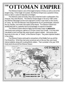
The Ottoman Empire
In this Ottoman Empire worksheet, students read a 1-page selection about the empire and examine a map. Students then respond to 5 short answer questions about the reading selection and the map.
Curated OER
Community Map
In this community map worksheet, students practice their map reading skills as they use the map key to determine the locations of community places on the map.
Curated OER
Ancient Rome: Map Work
Seventh graders explore the Roman Empire. In this ancient Rome lesson, 7th graders use digital and print maps to examine the geography of the Roman empires. Students are assigned regions of the empire to analyze and present their...
Curated OER
Mapping My World
Students are introduced to simple maps and view a map of a classroom and compare distances of items shown.
Curated OER
Let's Make a Map
Second graders draw maps of their playground, noting objects such as trees and play equipment. Working in groups, they make maps of different parts of the school and assemble them into a schoolwide map. They make maps on a field trip to...
Curated OER
Social Studies For Elementary School
Fourth graders become familar with maps and work in groups to get an overview of what Europe is like. The real assignment is in the form of students creating their own trip if it could really be taken.
Curated OER
Adventures With Maps And Globes
First graders examine the differences between a map and a globe. They discuss and identify the symbols on maps and globes, then in small groups complete a worksheet. Students then complete a Venn Diagram comparing maps and globes.
Curated OER
Using Map Skills
Third graders study maps. In this U.S. geography lesson, 3rd graders explore directions on a compass rose and use a map scale to determine distances between two points on a map. They listen to a lecture and use their own maps to practice...
Curated OER
N is for Natural State
For any pupils who live in the state of Arkansas, this would be a fabulous educational experience to help them get to know their state better. Through the use of activities in literature, art, mathematics, science, social studies, and...
Curated OER
Building an Empire Mapping China
Middle schoolers create travel brochures of China's nine regions and make a bulletin board display with them.
Curated OER
Absolute Location
Fifth graders examine the geographic concept of absolute location. Using a variety of resources, they create a life-size classroom grid and locate the coordinates of a point, identify latitude and longitude of different locations, and...
Curated OER
Physical Features
Students draw physical land features using ClarisWorks or Kid Pix, write their definitions, create slideshow, and create class geography book.
Curated OER
Valentine City
Students construct a small city on a table in the classroom. Each student is given a lot to develop. They give directions from one location to another, and write letters with correct addresses to their classmates.
Curated OER
Where in the World
Students explore the global grid system. In this globe instructional activity, students identify latitude and longitude lines and how these can tell the coordinates of any place. They use the Internet to find the exact coordinates for...
US Mint
Absolutely and Relatively: The Puerto Rico Quarter Reverse
How much does your class know about Puerto RIco? How much can they learn from the back of a 2009 quarter? Use the coin, part of a series of quarters that depict US territories, to teach learners about the geography, culture, and history...
Curated OER
Maps In Our Everyday Lives
Learners break into groups and complete a chart about information on maps of their hometown.
Curated OER
The Importance of Site Maps in Archaeology
Students consider the importance of site maps in archeology. They interpret site maps, draw site maps of their classroom and home and then participate in simulated Paleolithic archeological camp activity.
Curated OER
Latitude and Longitude- Online Interactive
In this maps worksheet, learners learn about longitude and latitude by reading a two paragraph text and studying two maps. Students answer 9 fill in the blank questions. This is an online interactive worksheet.
Curated OER
Lesson Nine: Size and Scale
Young scholars investigate scale as it is related to maps. In this map instructional activity, students read Jack and the Beanstalk by Carol North. Young scholars then compare the setting in the story to a landscape picture map to help...
Curated OER
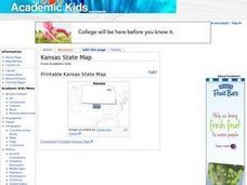
Kansas State Map
In this map of Kansas worksheet, learners color and label major cities and physical features of this state. Students also study the location of Kansas in relation to the other states in the U.S. by studying the background map.
Curated OER
Getting to the Core of World and State Geography
Students create topography relief maps. In this geography skills lesson, students review geography core knowledge skills, design and make a state relief map, and compile a student atlas.


