Curated OER
Take a Hike
In this geography skills instructional activity, students respond to 9 questions that require them to read topographic maps and interpret them. The topographic maps are not included.
Curated OER
CLASSROOM MAPS
Students do a blind tour of their school by responding to verbal commands. They look and discuss various maps in the classroom. They locate the direction of the sunrise and discuss the compass directions of North, South, East, and West.
Curated OER
Underground Rails: The New York City Subway System
Pupils explore the New York Subway system. They investigate its usefulness as mode of transportation for the people in the city and study its history compared to other city subway systems. They examine how the subway connects the various...
Curated OER
World Map and Globe-Equator, North Pole, and South Pole
Students identify the Equator, North Pole, and South Pole on a map. In this geography lesson, students use a world map and circle the North and South Pole. Students locate the Equator on a globe and use a map marker to highlight it.
Curated OER
Grades 6-8 Lesson Plan - Cities as Transportation Centers
Students examine maps of the 1800's and 1900's. In this geography skills lesson, students collaborate to read core maps and identify transportation centers and travel networks.
Curated OER
Europe Before and after WWI
Eighth graders compare and contrast maps of Europe before and after World War I. In this World War I activity, 8th graders color and label maps of Europe prior to the war and after it. The historical maps can be accessed online.
Curated OER
Establishment of Plainfield
Eighth graders analyze documents and maps of Plainfield, CT from different time periods, then, working in a small group, create a map for a giventime. In this Plainfield lesson, 8th graders read primary and secondary sources...
Curated OER
The United States in 1790
In this geography skills worksheet, students study the provided map of the United States in 1790 and then complete the provided quiz over the 17 states and territories.
Curated OER
The Global Grapefruit - Representing a 3-Dimensional Globe on a 2-Dimensional Map
Students compare and contrast world maps and globes. They convert a 3-dimensional globe to a 2-dimensional map. They are introduced to the Mercator map projection. They observe map distortions of shape, area, distance, directions and angle.
Curated OER
Studying the Haitian Immigration: 18th and 19th centuries
Students read a narrative and conduct extensive research to determine how Haiti's population has had an influence on the social, political, and economic culture of present-day Louisiana. As a culminating activity, students write papers...
Curated OER
Map of the Ottawa Valley
Students locate Ottawa Valley on a map. They then answer questions in reference to the map such as: What was the first use of timber in the Ottawa Valley?, What occurred first in Gatineau?, and On the Ontario side of Ottawa River, how...
Curated OER
Mapping Crime
Young scholars use data on break and enter crime incidents to make a map that prompt discussion about the spatial location of crime in the city, why it would occur in those places, and how residents may reduce crime.
Curated OER
WORLD GEOGRAPHY
Students identify and analyze map symbols and map grids by completing various worksheets and creating their own map using these skills. Students identify and analyze what latitude and longitude are on a map to play a game of Bingo....
Curated OER
The Changing Landscape
Students explore how the landscape is constantly changing. In this landscape lesson, students identify a building under construction on the Landscape Picture Map. Students discuss the purpose of the construction and the effect on the...
Curated OER
Matching the Globe with the Map
Students examine how to use a globe. In this globe and map comparison lesson, students discuss how the globe and map are alike when looking at Africa and Antarctica. Students investigate shapes and sizes of globes versus maps.
Curated OER
Where in The World Am I?
Students explore the concept of absolution location. In this geography skills lesson, students discuss how to identify and locate latitude and longitude. Students play a game to reinforce the skills.
Curated OER
What if the Mormons had not come to Utah?
Fourth graders use critical thinking, evaluation, and geography skills to find alternative locations that Brigham Young could have taken the Mormons to settle.
Curated OER
Latitude and Longitude
Students find latitude and longitude on a map or atlas. They create maps with a cruise route. They practice plotting locations given latitiude and longitude.
Curated OER
Map Your Local Watershed!
Pupils study how to map their local watershed from a topographic map. They find the watershed on an aerial photograph and use maps and aerial photos from the Web to identify the human activity within the watershed, as well as various...
Curated OER
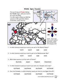
Middle Ages Traveler
In this map worksheet, students are given three maps of France to use to answer multiple choice questions. Students complete an activity from the perspective of a Middle Ages traveler.
Curated OER
Mapping Material Culture Worksheet
In this folk regions worksheet, students study the objects by visiting the URL links, and then decide whether each of the 25 belongs in the North Louisiana, South Louisiana, or New Orleans folk regions.
Curated OER
World Map and Globe- Introduction to Symbols
Students investigate picture symbols. In this symbols lesson plan, students define symbols and discuss symbols that they see in everyday life. Students identify symbols on maps by using post-it notes.
Curated OER
The Geography of Europe
Students examine maps of Europe. In this geography skills lesson, students interpret several maps to determine the boundaries of the European Union and respond to assessment questions about the maps.
Curated OER
Finding My Way
Learners determine a route from their home to the Stones River National Battlefield. In this map work lesson plan, students use a detailed city map of Murfreesboro to locate a route to the Stones River National Battlefield. They follow...


