Little 10 Robot
Geography Drive USA™
A trivia-style virtual road trip in which the player's car is moved from state to state as questions are correctly answered. Ideally, a player would learn about different states by reading the simple brochures available in the...
Environmental Education in Wisconsin
Biome Travel Guide
In a perfect marriage of social studies and science, groups work together to research and create a travel guide presentation to share with the class. Not only do kids learn about the climate and geography of a biome, but also the...
New York State Education Department
Global History and Geography Examination: June 2011
People in Ukraine, Rwanda, and Cambodia have all faced challenges to their human rights and even genocide. Using primary and secondary sources, scholars evaluate these challenges and the international community's role in them. The...
World Maps Online
Introduction to the World Map
Learners identify the differences between maps and globes. In this map skills instructional activity, students are shown a globe and a map and recognize the differences. Learners use post-it notes to locate several locations on the world...
Curated OER
Geography and Topography, History and Architecture
In this social studies lesson plan, students answer short answer questions about the geography, topography, history, and architecture of the east part of the United States. Students complete 24 questions.
Curated OER
Geography/Current Events Project
Using the Balkan region as an example, fourth graders review the five themes of geography as a class. They identify the physical and human characteristics of a region before labeling the countries and landforms on a map. They then...
Curated OER
Ozark Folk Culture and Geography in the Mountain View, Arkansas Area
Upper grade through early high schoolers develop an understanding of Ozark culture, and the geography of the Ozark Plateau. They study place, location, human environmental impacts, and movement. This interesting plan incorporates muic,...
Curated OER
Trekking to Timbuktu: The Geography of Mali -Teacher Version
Students investigate the geography of Mali. They locate Mali on a satellite map, explore various websites, describe the landscape and climate, label a map, and write an essay about the Niger Riger.
Channel Islands Film
Once Upon A Time (Saxipak’a): Lesson Plan 1
As part of a study of the history of the Chumash on California's Channel Island chain, class members view the documentary Once Upon a Time, respond to discussion questions, and create a timeline for the different waves of migration.
NET Foundation for Television
1850-1874 Homestead Act Signed: The Challenges of The Plains
Start a whole new life in a land known as the Wild Wild West! Learners analyze maps, personal accounts, the Kansas-Nebraska Act, songs, and video clips to uncover life under the Homestead Act. Using their new skills, class members role...
Curated OER
The blues highway: An integration of music with geography
Students analyze the movement of the blues from rural Mississippi to urban Chicago and how place and the environment affected the development of the blues. They define the blues, where it originated and how and why it moved to Chicago....
Curated OER
The Geography of China
Viewers will love this field trip to China, complete with information about China's economy, topography, geography, climate, and demographics. Maps and photos help to support the claims in the slides, especially in some interesting...
Curated OER
Texas Commemorative Maps: Honoring Our Past
To celebrate Texas, groups plan and create a commemorative map for a topic or theme in Texas history. The richly detailed plan and the approach could easily be adapted to any state. Samples are included.
Curated OER
The Geography of Japan
A comprehensive look at Japan and its characteristics will engage and inform the viewer about one of the most prominent powers in the world today. The demographics, topography, and climate of Japan are covered in these slides with maps,...
Curated OER
Maps and the Pictures in Our Heads
Geographers of all ages examine different types of maps. They draw maps of their environment, utilizing both three-dimensional and picture maps. They interpret map information, noting how it can sometimes be misleading. Some good...
Curated OER
Finding Your Spot in The World; Geography, Maps, Multi-Culturalism
Students use a variety of maps to locate their home, their school and the origin of their ancestors.
Curated OER
Mapping Mistakes
Young scholars examine early European maps and explore geographic errors. They also view maps of the geography of North America. Students discuss the obstacles faced by early explorers in mapping unexplored territory. They consider what...
Curated OER
Basic U.S. Geography
Provide your 11th graders with a basic understanding of U.S. Geography. They label the state, regions, and boundaries found in the contiguous U.S. as well as Hawaii and Alaska. Then, they complete two Internet related activities.
Curated OER
Map Skills
Do you need to practice map skills? Children with a range of abilities will complete a KWL chart about maps, practice important map vocabulary and then read a few pages from their textbook. They will use their vocabulary words and...
Curated OER
Sub-Saharan Africa: Physical Geography
In this geography skills instructional activity, students respond to 22 short answer and map skills questions about the location and geographic features of sub-Saharan Africa.
Curated OER
Maps
If your students are just starting a unit on Geography this could be the introduction you're looking for. This PowerPoint presents a clear and organized overview of the different types of maps people use and why each is important. Tip:...
Curated OER
Grocery Store Field Study
Students visit a local grocery store (not a community market) to gather information about where some commonly eaten produce items come from. Once they have collected this information, locate the countries of origin on a map and research...
Curated OER
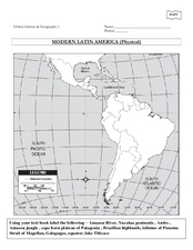
Global History & Geography: Latin America
The instructions say to use a text-book to label 11 different regions in modern Latin America. If a text-book is not available a map can be found on-line and printed for student reference.
Curated OER
Using Different Kinds of Maps
Third graders explore the landforms and population diversity. They read maps and examine geographic terms. Students create their own map of the United States and answer questions about the location of people. After exploring the map, 3rd...


