Curated OER
Chapter 3 Test: The Southeast States
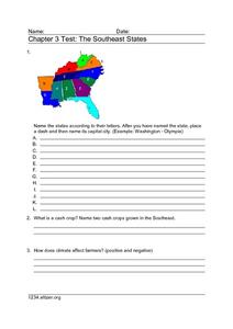
In this geography worksheet, students complete a test about the southeastern United States. They name the states, tell about the climate and crops, complete a matching activity about the landforms. and another about the industry.
Curated OER
Educational Technology Clearinghouse: Maps Etc: Alaska, 1920
A map of Alaska from 1920 showing the State capital at Juneau, cities, towns, ports, railroads, overland and submarine telegraph lines, major rivers and mountains, coastal features, and islands. The map has inset maps detailing the areas...
Curated OER
Educational Technology Clearinghouse: Maps Etc: England Plate Iii, 1920
A regional map of southeastern England from 1920, showing major cities, towns, and ports, railways and canals, and counties with the county boroughs underlined in red. The map shows major rivers and coastal features. This map shows the...
Curated OER
Educational Technology Clearinghouse: Maps Etc: Haddington & Berwick, 1908
A detailed travel map of southeastern Scotland from 1908, showing portions of counties Edinburgh, Haddington, Peebles, Selkirk, and Roxburgh. A portion of Northumberland (England) north of Rothbury is shown. The map shows first class and...


