Houghton Mifflin Harcourt
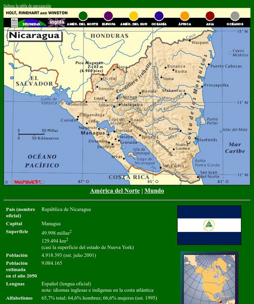
Holt, Rinehart and Winston: America Del Norte: Nicaragua
This site has a map of Nicaragua in Spanish, with informational data also presented in Spanish about the country. Land mass, population, life expectancy, literacy, industry, agriculture, minerals, and resources are among the topics...
Houghton Mifflin Harcourt
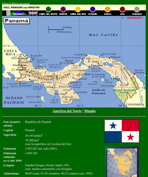
Holt, Rinehart and Winston: America Del Norte: Panama
This site has a map of Panama in Spanish, with informational data also presented in Spanish about the country. Land mass, population, life expectancy, literacy, industry, agriculture, minerals and resources are among the topics...
Houghton Mifflin Harcourt
Holt, Rinehart and Winston: Caribe: Cuba
This site has a map of Cuba in Spanish, with informational data also presented in Spanish about the country. Land mass, population, life expectancy, literacy, industry, agriculture, minerals, and resources are among the topics addressed....
Houghton Mifflin Harcourt
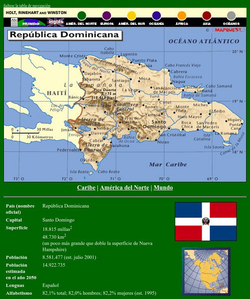
Holt, Rinehart and Winston: Caribe: Republica Dominicana
This site has a map of the Dominican Republic in Spanish, with informational data also presented in Spanish about the country. Land mass, population, life expectancy, literacy, industry, agriculture, minerals, and resources are among the...
Houghton Mifflin Harcourt
Holt, Rinehart and Winston: America Del Sur: Argentina
This site has a map of Argentina in Spanish, with informational data also presented in Spanish about the country. Land mass, population, life expectancy, literacy, industry, agriculture, minerals, and resources are among the topics...
Houghton Mifflin Harcourt
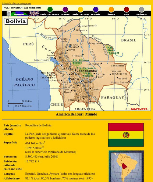
Holt, Rinehart and Winston: America Del Sur: Bolivia
This site has a map of Bolivia in Spanish, with informational data also presented in Spanish about the country. Land mass, population, life expectancy, literacy, industry, agriculture, minerals, and resources are among the topics...
Houghton Mifflin Harcourt
Holt, Rinehart and Winston: America Del Sur: Chile
This site has a map of Chile in Spanish, with informational data also presented in Spanish about the country. Land mass, population, life expectancy, literacy, industry, agriculture, minerals and resources are among the topics addressed....
Houghton Mifflin Harcourt
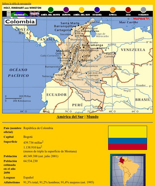
Holt, Rinehart and Winston: America Del Sur: Colombia
This site has a map of Colombia in Spanish, with informational data also presented in Spanish about the country. Land mass, population, life expectancy, literacy, industry, agriculture, minerals and resources are among the topics...
Houghton Mifflin Harcourt
Holt, Rinehart and Winston: America Del Sur: Venezuela
This site has a map of Venezuela in Spanish, with informational data also presented in Spanish about the country. Land mass, population, life expectancy, literacy, industry, agriculture, minerals, and resources are among the topics...
Houghton Mifflin Harcourt
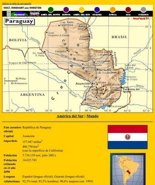
Holt, Rinehart and Winston: America Del Sur: Paraguay
This site has a map of Paraguay in Spanish, with informational data also presented in Spanish about the country. Land mass, population, life expectancy, literacy, industry, agriculture, minerals and resources are among the topics...
Houghton Mifflin Harcourt
Holt, Rinehart and Winston: America Del Sur: Peru
This site has a map of Peru in Spanish, with informational data also presented in Spanish about the country. Land mass, population, life expectancy, literacy, industry, agriculture, minerals and resources are among the topics addressed....
Houghton Mifflin Harcourt
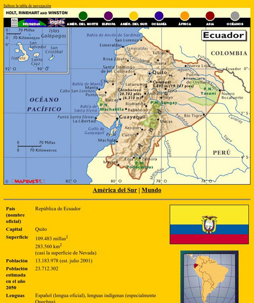
Holt, Rinehart and Winston: America Del Sur: Ecuador
This site has a map of Ecuador in Spanish, with informational data also presented in Spanish about the country. Land mass, population, life expectancy, literacy, industry, agriculture, minerals, and resources are among the topics...
Houghton Mifflin Harcourt
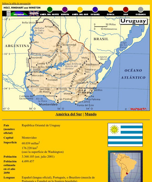
Holt, Rinehart and Winston: America Del Sur: Uruguay
This site has a map of Uruguay in Spanish, with informational data also presented in Spanish about the country. Land mass, population, life expectancy, literacy, industry, agriculture, minerals and resources are among the topics...
Houghton Mifflin Harcourt
Holt, Rinehart and Winston: Europa: Espana
This site has a map of Spain in Spanish, with informational data also presented in Spanish about the country. Land mass, population, life expectancy, literacy, industry, agriculture, minerals, and resources are among the topics...
Instituto Latinoamericano de la Comunicacion Educativa
Red Escolar: Coloreando Matematicas
In Spanish. Cartographers know that four colors are enough to illuminate their maps thus making their maps clear and easy to understand. Try to color the maps by following the two rules: 1) use the least number of colors and 2) keep in...
Curated OER
Etc: Colonization of North Western Africa, 1845 1900
Map of Northwestern Africa, subtitled "French Colonization." This map shows the Barbary States of Morocco, Algeria, and a portion of Ottoman controlled Tripoli. The map is color-coded to show the progression of French occupation in...
Curated OER
Etc: Route of Lewis and Clark, 1803 1806
A map showing the route and winter camps of the Lewis and Clark explorations from St. Luis in the Louisiana Territory to Astoria on the Pacific in Oregon Country (1803-1806). The map shows natural boundaries of the British possessions...
Curated OER
Etc: The Territory of the Present Us During the French Indian Wars, 1755 1763
A map of North America showing the foreign possessions in the area of the present United States during the French and Indian Wars (1755-1763) between the French and English. This map is color-coded to show territorial claims at the time...
Curated OER
Etc: Acquisition of Territory, 1783 1884
A map from 1885 of the United States showing the territorial growth from the original States and the Northwest Territory in 1783 to the Russian cession of Alaska in 1867. The map is color-coded to show the progression from the original...
Curated OER
Etc: French Expansion and British Conquests in North America , 1700 1763
A map of eastern North America showing the British and French territorial expansion in the region between 1700 and the end of the French and Indian War in 1763. The map shows the principal stages in the acquisition of Eastern North...
Curated OER
Etc: The Louisiana Purchase, 1803 1809
A map of the United States and the Louisiana Territory showing boundary disputes and boundary claims between 1763 and 1809. The map shows the natural boundaries and extent of the original Louisiana Territory claimed by the French, the...
Curated OER
Etc: The Territorial Growth of the United States , 1783 1853
A map from 1894 of the United States showing the territorial growth from the original States and the Northwest Territory in 1783 to the Russian cession of Alaska in 1867. The map is color-coded to show the progression from the original...
Curated OER
Etc: Territorial Acquisitions of the United States, 1783 1900
A map from 1920 of the United States and its territories between 1783 and 1900 showing the nation's expansion and date of acquisition of each new territory or possession. The map is color-coded to show the progression from the original...
Curated OER
Etc: Development of Amer Interests in the Pacific, 1791 1903
A map of the United States and Pacific Ocean showing the development of American interests in the Pacific from the early exploration of Oregon Country in 1791 to the formal annexation of the Midway Islands and the Panama Strip in 1903....


