Curated OER
Mollusks and Annelids Concept Map
In this mollusks and annelids concept map learning exercise, students complete a concept map on the characteristics of invertebrates. They fill in 13 blanks using the correct word from the list.
Curated OER
Modern Reptiles Concept Map
In this life science activity, students complete a concept map on modern reptiles. They answer 13 fill in the blank questions using words from the list.
Curated OER
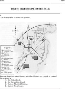
Fourth Grade Social Studies
For this social studies worksheet, 4th graders answer multiple choice questions on state maps, city maps, road maps, political maps, and more. Students complete 25 multiple choice questions.
Curated OER
Clouds
In this recognizing cloud shapes and their elevations worksheet, students cut out labeled cloud shapes and paste them on an elevation map. Students identify the location of five cloud shapes.
Curated OER
Growth of Florida's Railroads
Based on an examination of Florida's railroad system, this multi-step lesson addresses FCAT requirements specific to Florida. After reading a passage, scholars use a map of the state to label railroad systems. They describe the goods...
Agriculture in the Classroom
A Holiday Tradition: Which Christmas Tree Will You Choose?
Different varieties of Christmas trees provide an interesting way to combine social studies, science, math, and technology. Class members not only research the history of the Christmas tree holiday tradition, they compare and...
Curated OER
Learn the States and Postal Abbreviations
If you are preparing to cover the 50 states with your class, you don't want to miss this resource. It includes an excellent set of worksheets through which learners practice identifying states from their abbreviations and placing those...
Curated OER
Look for Patterns
In this earthquakes worksheet, students look at maps of earthquake patterns and answer short answer questions. Students answer 12 questions.
Laboratory for Atmospheric and Space Physics
Charting the Progress of New Horizons
In 2006, New Horizons began its mission to fly to Pluto. As it continues its journey, scholars track its progress with the help of an informative website, all the while reinforcing measurement concepts with the construction of a scaled...
British Council
Weather 1
Match weather words with pictures in a weather vocabulary worksheet. Beginning readers look at pictures of various weather patterns and choose/write the word that describes the weather. They create a map and write about the weather...
MENSA Education & Research Foundation
Peas in a Pod: Genetics
Can peas have grandparents? Learn about inherited traits and heredity with a set of activities focused on Mendelian genetics. As your class learns about the process of passing traits along in Punnett squares, they take on the role of...
Mathematics Assessment Project
Sorting Functions
There's no sorting hat here. A high school assessment task prompts learners to analyze different types of functions. They investigate graphs, equations, tables, and verbal rules for four different functions.
Curated OER
Weather Map Challenge
In this weather worksheet, students use a weather map to answer ten questions about the information found on a weather map and what the symbols mean. They find the cities with the highest and lowest temperature as well as the cities...
Curated OER
Extreme Weather and Mapping
For this environment worksheet, students read an article about extreme weather conditions and mapping it out. They respond to 10 multiple choice questions about what they read. Then, students explain how droughts can occur and the...
Curated OER
School-Home Link: Maps
In this atlas and parent communication form worksheet, students use an atlas to find several things: the capitol city of Japan, the number of countries in Africa, where to buy a newspaper, the names of Presidents of the United States,...
Curated OER
Outline Map of Japan
In this geography worksheet, students examine a black line outline map of Japan. There is a compass rose on the page. There are no labeled cities.
It's About Time
Volcanic History of Your Community
Did you know there are 20 volcanoes erupting at any given time? Pupils look at various igneous rocks, read local geologic maps, and determine if their area has a history of volcanic activity. A reading passage and analysis questions...
Oregon State
World Map of Plate Boundaries
Young geologists piece together the puzzle of plate tectonics in an earth science lesson. Given a physical map of the world, they search for land formations that indicate the location of different types of plate boundaries.
Curated OER
Gotham Equinox
By looking at the direction of the parallel streets of New York and figuring which days the setting sun is directly visible along those lines, your class can calculate the degree and angle of the sun. A really nice lesson, giving a...
Curated OER
Regents High School Examination: Physical Setting Earth Science 2010
Every topic under the sun is covered in this New York State Regents High School Examination. With the focus of earth science, participants answer 85 quesitons about the solar system, geologic time, rocks and minerals, landforms, and...
Curated OER
Regents High School Examination: Physical Setting Earth Science 2006
Test your class on earth science with this extensive resource. This test, created by The University of the State of New York Regents, is made up of 50 multiple choice questions and 32 short answer questions that cover the branches of...
Port Jefferson School District
Hurricane Katrina
Young scientists track Hurricane Katrina across the Atlantic Ocean as they learn about these destructive forces of nature. Provided with a table of data tracking the location and conditions of Katrina over a one week span, students...
GCSE Modern World History
Mao's China
Here is a great textbook chapter on China's establishment as a communist state in 1949 and the effects of World War II on the nation. The first page prompts learners to complete a timeline activity as they read the material,...
Gymnázium Karviná
Australia and New Zealand
Send your learners off on a research adventure with a worksheet on essential facts about Australia and New Zealand. It includes 18 short-answer response questions, as well as a map activity where pupils locate a variety of...
Other popular searches
- Different Types of Maps
- Reviewing Types of Maps
- Types of Maps Grids
- Types of Maps Worksheets
- 10 Types of Maps
- Three Types of Maps
- 2 Types of Maps
- Types of Maps Australia
- Types of Maps "Australia
- Types of Maps "Australia"
- Maps Types Key Symbols


