Curated OER
South America
For this South America word search worksheet, students locate the names of 35 South American countries. The word search is in the shape of the South American continent.
Curated OER
Pacific Islands Crossword
In this geography activity, students complete a crossword puzzle about the Pacific Islands. The twenty-three clues are about capitals, countries, and terrain.
Curated OER
Asia Crossword
In this geography instructional activity, students complete a crossword puzzle about Asia. The twenty-one questions are about capitals, countries, and terrain.
Curated OER
Deserts Crossword
In this geography crossword puzzle, students answer twenty-one questions about deserts. Among the topics are plants, animals, and terrain.
Curated OER
Asia Crossword
In this geography instructional activity, students complete a crossword puzzle on the continent of Asia. They answer 21 questions related to the type of government systems found, capital cities, deepest lake, and lowest population density.
Curated OER
Choropleth Mapping Skills
In this geography worksheet, students identify and describe how to apply choropleth mapping skills. They examine the map given and convert it into a choropleth map through coloring. Then students use those colors to shade in their key...
Curated OER
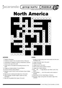
North America Puzzle
In this geography worksheet, learners complete a crossword puzzle in reference to North America. They identify capitals of some countries, the specific landforms of different areas, and languages spoken. There are 21 clues to solving the...
Curated OER
North America Puzzle Answer Sheet
In this geography worksheet, students name the capitals of various countries found in North America. They also identify the various weather patterns across the continent and specific bodies of water. There are 21 descriptions and 21...
Curated OER
Read a Transportation Story
Third graders research the building of a transcontinental road. In this railroad history lesson plan, 3rd graders discuss past and present transportation. Students look at historical photos and compare and contrast photos from today.
Curated OER
Ancient Mesopotamia
In this geography worksheet, students read about ancient Mesopotamia and respond to five short answer questions that follow. They identify what part of the country was the heart of Mesopotamia. Then students compare the given map with a...
Curated OER
Children's Crusade
In this geography learning exercise, students read an excerpt about the Crusaders compromised of two of children. They use the map given to determine how far apart each army marched before reaching the Mediterranean Sea. In addition,...
Curated OER
A Natural Connection to the Azores
Students use primary sources to examine whaling voyages, biology, and geography. In this geography lesson, students analyze ship logs and plot locations of animals and determine routes using latitude and longitude.
Curated OER
Mural Mania
Students research and discuss symbols and features of their state. They create a mural representing their state and design a quarter for their state.
Curated OER
The Ethics of Outsourcing to China
After viewing clips from a documentary on factory work in China and US outsourcing, learners have a fishbowl discussion. They work in groups to build both personal points of view and strong arguments on the effects of outsourcing in...
New York State Education Department
TASC Transition Curriculum: Workshop 11
You'll C-E-R a difference in classroom achievement after using a helpful lesson. Designed for economics, civics, government, and US history classes, participants practice using the CER model to craft arguments about primary and secondary...
Curated OER
"Across Oregon On The 45th N Parallel" A Transect of Oregon
Students explore the physical geography of Oregon. In groups, students collect weather and elevation information on Oregon. They organize the data and create maps and graphs of the information. Afterward, students compare the...
Curated OER
FROM SEA TO SHINING SEA
Identify agricultural products grown in each region of the country.
Discuss how geography affects what is grown or raised in a particular area.1. Hand out a copy of the two activity sheets "Food From Sea to Shining Sea" to each student....
Curated OER
National Parks
In this geography worksheet, students examine the names of 15 National Parks in America. Students locate the names in a word search puzzle.
Curated OER
Satellite Images- Night Time
Fourth graders study the geography and population distribution of various places on earth. They utilize actual satellite images of the night sky (lights showing heavily around area of dense population) to study and make observations...
Curated OER
Math: Road Trip
Twelfth graders use road maps to calculate the distance between two locations. They estimate the cost for fuel and the miles per gallon. They consider other factors such as geography, road conditions, and traffic that may impact the cost.
Curated OER
Deserts Word Search
For this geography and environment worksheet, students locate the names of 20 of the world's deserts in a word search puzzle of medium difficulty.
Curated OER
Antarctica Word Search
In this geography learning exercise, students analyze 16 words in a word bank that pertain to Antarctica. Students find these words in a word search puzzle.
Curated OER
US City Quality of Life Analysis and Comparison
Students analyze US census data and criteria to compare and measure the quality of life in the country's fifty largest cities. After accessing the 2005 quality of life world report online, students conduct their study to compare three...
PBS
The Media and the War: The Penny Press, Walt Whitman and the War
The Mexican-American war marked a significant moment in United States history, as well as in the history of American media. The mid-nineteenth century saw the introduction of the Penny Press, which provided many American citizens with...


