Curated OER
Historical Map - United States: The Changing Frontier
In these United States frontier worksheets, students study the map of the United States frontier for various sections of time in the history of the United States. Students then finish a crossword puzzle using the various parts of the...
Curated OER
U.S. Geography for Children: The Northeast
For this map skills of the northeastern United States worksheet, students observe an outline map, locate and label the states, and designated landforms and bodies of water; and create symbols and a map key for sources of economy and...
Curated OER
Tears of Joy Theatre Presents Anansi the Spider
Accompany the African folktale, Anansi the Spider, with a collection of five lessons, each equipped with supplemental activities. Lessons offer multidisciplinary reinforcement in English language arts, social studies, science,...
Curated OER
Map Activity: Place Name
In this map worksheet, students locate given words on a map of the United States, then answer a set of 4 related short answer questions.
Houghton Mifflin Harcourt
Surprise!: Extra Support Lessons (Theme 2)
Surprise! is the theme of a unit covering such topics as consonants, blending, short vowels sounds, high frequency words, and number words. The unit's lessons also include teachable moments covering story structure, illustrations,...
Curated OER
Revolution! The Atlantic World Reborn
This resource is rich with primary and secondary source material regarding major events in the Atlantic world during the Age of Revolution. While there are suggested classroom activities toward the beginning of the resource, its true...
Core Knowledge Foundation
Columbus Sailed the Ocean Blue
Young adventurers embark on a journey, setting sail along the blue ocean with Christopher Columbus. Teachers will find that this unit makes their lesson planning smooth sailing!
Curated OER
Africa Capitals Map Quiz
In this online interactive geography quiz worksheet, students examine the map that includes 53 African countries. Students match the names of the countries to the appropriate locations.
Curated OER
North American Biomes
In this Science worksheet, students color a biome map of North America. Students color the map by solving the clues listed on a separate sheet of paper.
Curated OER
Precipitation Map
In this precipitation map instructional activity, students study the key and the map for the various precipitations that occur across the United States. Students then answer questions about the precipitation.
Noyce Foundation
Lawn Mowing
This is how long we mow the lawn together. The assessment requires the class to work with combining ratios and proportional reasoning. Pupils determine the unit rate of mowers and calculate the time required to mow a lawn if they work...
PBS
Working with Coordinate Planes: Activities and Supplemental Materials
Seven activities make up a collection of supplemental materials to reinforce graphing on a coordinate plane. Worksheet objectives include plotting coordinates within single and four quadrants, measuring straight and...
T. Smith Publishing
48 Contiguous States
What do your pupils know about the United States? This resource asks learners to respond to 10 questions about certain states and landmarks. Useful for a geography lesson and to help familiarize your learners with the continent. An...
Curated OER
Old Stone House Lesson Plan
From stagecoach to railroad tracks, your class will discover how advancements in travel in the United States during the nineteenth century played an integral role in the industrialization and development of American society. The main...
Texas State Energy Conservation Office
Investigation: Tour de Texas
Teams of Texas tourists gather into groups to analyze what they can do with $50 worth of an alternative fuel. They write checks, keep a balance sheet, and map out their sight-seeing route taking into consideration the location of...
Illustrative Mathematics
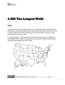
The Longest Walk
How long of a line can you draw within this activity? Learners pick two points outside and within the map to create the longest line they can. After drawing 10 lines, learners plot the length of each line on a line plot. Then they...
International Technology Education Association
Become a Weather Wizard
Accurate weather forecasting is something we take for granted today, making it easy to forget how complex it can be to predict the weather. Learn more about the terms and symbols used to forecast the weather with an earth science lesson...
Teach Engineering
What's Wrong with the Coordinates at the North Pole?
Here is an activity that merges technology with life skills as individuals use Google Earth to explore the differences between coordinate systems and map projections. The self-guided worksheet is the fourth segment in a nine-part unit....
It's About Time
Present-Day Climate in Your Community
So what exactly is climate? This first installment of a six-part series introduces the concept of climate using real-world data tables and topographic maps. The timely lesson includes a comprehensive overview of climate, as well as...
Curated OER
Biggest Metro Areas in the USA
For this online interactive geography quiz worksheet, students respond to 100 identification questions about metropolitan areas in the United States. Students have 10 minutes to complete the quiz.
Curated OER
Hottest US Cities Quiz
In this online interactive geography quiz worksheet, students respond to 20 identification questions about the hottest cities in the United States. Students have 4 minutes to finish the timed quiz.
Curated OER
Coldest US Cities Quiz
In this online interactive geography quiz worksheet, students respond to 20 identification questions about the coldest cities in the United States. Students have 4 minutes to complete the quiz.
Curated OER
Southwest Bus Ride
In this geography skills practice worksheet, students take a trip through the southwestern United States as they examine maps, information cards, and respond to 12 questions.
GCSE Modern World History
Mao's China
Here is a great textbook chapter on China's establishment as a communist state in 1949 and the effects of World War II on the nation. The first page prompts learners to complete a timeline activity as they read the material,...


