Constitutional Rights Foundation
Refugees from the Caribbean: Cuban and Haitian “Boat People”
Should refugees fleeing poverty be allowed the same entrance into the United States as those fleeing persecution? High schoolers read about US foreign policy in the late 20th century regarding refugees from Cuba and Haiti, and engage in...
C-SPAN
The Electoral College and the Constitution
What is the purpose of the Electoral College? Is it antiquated, or does it have a place in today's political climate? High schoolers view a series of video clips as they analyze the parts of the United States Constitution that address...
Curated OER
Africa: Political Map
Students create a political map for Africa. In this country identification instructional activity, students locate Africa on a globe and discuss some of its major countries and bodies of water. Students complete a political...
Curated OER
United States Map Lesson
Students explore basic map skills. In this United States geography lesson, students define "country" and "state," locate their state on a United States map, and identify and trace state boundaries defining their state and surrounding...
Curated OER
Tibet and the U.S.
Students examine the relationship between Tibet and the United States. They explore the political relationship between the two countries. Students identify geographical features and political boundaries of the Tibetan and Chinese regions.
New York State Education Department
US History and Government Examination: January 2012
What led to the United States Civil War? Interested historians consider a variety of political, social, and economic factors using primary sources and an essay prompt in an authentic high-stakes test. Primary sources include political...
Curated OER
The Kansas-Nebraska Act of 1854: Popular Sovereignty and the Political Polarization over Slavery
Why did Stephen Douglas support the Kansas-Nebraska Act of 1854? Why did Abraham Lincoln oppose it? Young historians examine how the Kansas-Nebraska Act of 1854 affected the political balance between free and slave states and explore how...
Curated OER
Using Different Kinds of Maps
Third graders explore the landforms and population diversity. They read maps and examine geographic terms. Students create their own map of the United States and answer questions about the location of people. After exploring the map, 3rd...
Curated OER
U.S. Political Map
Students explore the symbols found in a map legend. In this map skills lesson, students locate the legend on a political map and explain what each of the symbols mean. Students locate and identify several symbols on the map.
Curated OER
United States of America Map: Capitals
In this United States outline map worksheet, students note the political boundaries of the states that are labeled with postal abbreviation codes as well the labeled state capitals.
Curated OER
Women in Texas Politics: Winning the Vote, Three Pioneers, and Serving the People
Fourth graders study women's involvement in Texas politics. In this US history lesson, 4th graders discuss woman suffrage, examine three Texas female pioneer legislators by reading biographies, and explore women's issues by generating a...
Curated OER
The Brief American Pageant: Twenty-Three Political Paralysis in the Gilded Age
Detailing the Presidential elections of 1876, 1884, and 1892, this slideshow focuses on the final years of the 19th century in the United States. Additionally, slides include information on the changes in Southern plantations and growth...
Curated OER
US: Midwest Region
In this United States political map instructional activity, students examine the state boundaries of the Midwestern Region. The map also highlights each of the state capitals denoted by stars.
Curated OER
United States Map
Students describe cities they are familiar with. In this United States Map lesson, students understand how cities are listed on a map. Students become aware of a map legend and the information in it.
Curated OER
US: Northeast Region Map
In this United States political map activity, students examine the state boundaries of the Northeast Region. The map also highlights each of the state capitals denoted by stars.
Curated OER
Puerto Rico: The 51st State?
Students examine the political status of Puerto Rico. In this global studies lesson, students explore Puerto Rico and consider the feelings of Puerto Ricans regarding their unique political status.
New York State Education Department
US History and Government Examination: June 2018
Ready to test your learners about anything and everything related to United States history and government? The resource uses multiple-choice and essay questions to assess knowledge.
Curated OER
United States Map- Continent, Country, State
Young scholars identify their continent, country, and state on a globe. In this geography lesson plan, students use a globe to identify the seven continents, the United States, and the state which they live in. Young scholars define key...
New York State Education Department
US History and Government Examination: August 2016
Multiple-choice and essay questions test comprehension, writing ability, and skills with primary source analysis. The comprehensive exam covers many different subjects including the United States census, Constitution, and important...
New York State Education Department
US History and Government Examination: August 2010
Geography has played a complex role in America history. The Atlantic Ocean has served as a buffer to protect the United States from European Wars, but its proximity to Cuba, however, left it vulnerable to nuclear war during the Cuban...
PBS
What's In a Name?
What is in a name? Eager historians trace the geographical history of places in the United States with Spanish names. Using a worksheet activity, clues, and web research developed in conjunction with the PBS "Latinos in America" series,...
Curated OER
Looking at Human Struggle Through The Language Arts Curriculum: The Faces of Slavery
Sixth graders examine the use of slavery in the United States. Using a map, they draw the route of the Tecora and Amistad voyages. Individually, they write an essay describing their opinions on whether the Africans on the ships should be...
Curated OER
Immigration to the United States
High schoolers examine the reasons why people immigrated to the United States. Using maps and charts, they analyze population movements and religious affiliations. They discover how the United States became a lesser Protestant country.
Curated OER
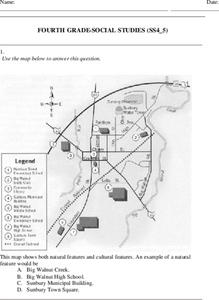
Fourth Grade Social Studies
In this social studies worksheet, 4th graders answer multiple choice questions on state maps, city maps, road maps, political maps, and more. Students complete 25 multiple choice questions.


