Curated OER
The 50 States
Students, in groups, research specific regions and states of the United States. They summarize their research and create a poster and PowerPoint presentation with their findings.
Curated OER
Travelogs
Students make travelog journals to send to acquaintances in other states in order to receive mail in return. They make scrapbooks with the return mail they receive.
Curated OER
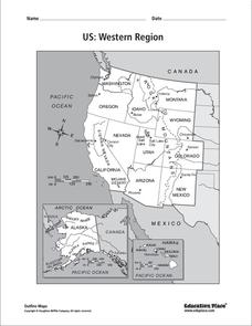
US: Western Region Map
In this United States Western Region worksheet, students examine the state boundaries and landforms found in this region. The map also highlights each of the state capitals.
Curated OER
Where Did My Lunch Come From? A U.S. Regional Tour
Pupils explore the five regions of the United States. In this social studies lesson, students discuss the regions and the states located in that region. Pupils discuss the types of food produced in each region and analyze a school lunch...
Curated OER
Where Did My Lunch Come From? A U.S. Regional Tour
Students explore the regions from which their food comes. In this social studies lesson, students identify the different agricultural products that are found in the major regions of the United States. Students create a lunch menu.
Curated OER
Solving the Puzzle
Students create a map showing the United States borders at a specific period in history and produce three questions to be answered by examining the map. They also write a productive paragraph explaining who, what, when, where, how/why a...
Museum of Tolerance
Disenfranchised People of the New Nation
Why are some immigrant groups in the United States embraced while others become disenfranchised? To answer this question, teams investigate why groups emigrated to the US, why some of these these peoples were disenfranchised, and their...
Curated OER
Data Comparison And Interpretation: North Korea, South Korea, And the United States
Ninth graders brainstorm "what they know about North Korea and South Korea." They determine the approximate distance from the United States to North and South Korea and create a graph comparing the birth rates, death rates, infant...
Curated OER
The Demographics of Immigration: Using United States Census Data
Learners work together to analyze United States Census data on immigration. They compare and contrast the data and determine how immigration numbers have changed over time. They calculate percentages and make their own conclusions...
Curated OER
Mural Mania
Learn about your home state. After listening to stories about your state, identifying symbols, and discussing what makes your region special, your class creates a mural.
University of California
The Civil War: The Road to War
The United States Civil War resulted in the highest mortality rate for Americans since the nation's inception. Delve deeper into the causes for the drastic separation of states with a history lesson plan that features analysis charts,...
Smithsonian Institution
We Have a Story to Tell: Native Peoples of the Chesapeake Region
How did colonial settlement and the establishment of the United States affect Native Americans in the Chesapeake region? Your young historians will analyze contemporary and historical maps, read informational texts, and work in groups to...
Curated OER
States and Capitals, Mountains and Rivers
Students identify geographical locations in the midwestern United States. In this geography instructional activity, students identify 12 states and capitals and geographical features in the region by using U.S. maps. Students use blank...
Curated OER
Midwest Region Commercials
Third graders research their assigned state using a variety of resources including a website, books, and travel brochures. They complete questions on a worksheet to use when writing a commercial for the state. They film the commercial...
Curated OER
Touring the Regions of the United States
Fifth graders explore the regions of the United States. In this geography skills lesson, 5th graders examine the landforms, climates, and economies of the regions of the United States. Students conduct Internet research in order to...
Curated OER
The Original 13 Colonies and 3 Regions
Seventh graders review the content of American History and focus upon the original thirteen colonies. They also study the geography of the region. It is recommended that students have other lessons delivered on the topic prior to this one.
Curated OER
Weather Pals
Young scholars study maps of the United States to locate weather pals from a list of schools. They communicate with Weather Pal schools through the use of closed circuit TV. Using weather data collected in their area, they exchange the...
Curated OER
Jimmy Carter: Civic Action, Lesson 1
Inspired by the humanitarian work of President Jimmy Carter after he left office, high schoolers explore the history of civic action in the United States and generate ideas about problems at the local, national, and international levels....
Federal Reserve Bank
The Story of the Federal Reserve: High School Lesson Plan
Is there a bank for the banks? Pupils analyze the complexities of the Federal Reserve system by breaking it down into easy-to-understand sections. Step-by-step investigation using flow charts and graphs of how the monetary system works...
Global Oneness Project
Citizen Photojournalism
Matt Black's photo essay, "The Geography of Poverty" provides a shocking reminder of the poverty that exists in the United States. The resource not only focuses attention on poverty but also conditions that have given rise to situation...
Curated OER
States and Capitals Unit
Fifth graders explore the regions, states, and capitals that make up the United States. Through the five lessons in this unit students locate and name the fifty states and their capitals.
Curated OER
Celebrate Kwanzaa in the United States
Students explore and study the celebration of Kwanzaa in which African-Americans remember their heritage and remind people of the importance of sharing with family and friends. They participate in a chant about the seven continents and...
Curated OER
Opening Doors to Social Studies with Children's Literature: The Desert Alphabet Book
Pupils explore the geography of the United States. In this social studies lesson, students identify the major deserts on a map of the United States.
National Energy Education Development Project
Introduction to Wind Energy
The U.S. produced enough wind energy in 2015 to power all of the homes in Alaska, California, Delaware, the District of Columbia, Hawaii, Idaho, Maine, Montana, Nebraska, New Hampshire, North Dakota, Rhode Island, South Dakota, and...
Other popular searches
- Regions of the United States
- 5 United States Regions
- Regions of United States
- United States Regions South
- Seven United States Regions
- Regions United States
- Regions in the United States
- United States Regions Maps
- 5 Regions of the United States
- Regions in United States


