Curated OER
Where Is That Place?
Students determine the difference between a country, state, and a city while recording the weather conditions for their school in Nebraska. They examine weather for another school in the state while practicing using weather equipment to...
Curated OER
Understanding Weather and Climate Patterns
Students research the climate patterns of various locations and make predictions based on their findings. They determine the importance of latitude and longitude in weather and climate. Students create graphs displaying their collected...
Curated OER
Lights, Shoals & Soundings
Students explore nautical charts and their symbols, with a bit of fun thrown in.
Curated OER
Why Kosovo? Why Now?
Middle schoolers explain the establishment of the modern state of Yugoslavia and the breakup of the country. They examine the human characteristics of the region - ethnic groups, languages, and religions.
Curated OER
The ABC's of Apportionment
Students are introduced to the terms of apportionment and redistricting. Using a Census map, they identify the states that had the highest and lowest numbers of change during the past ten years. They examine a map of voting districts and...
Curated OER
My Brother, My Enemy
Students visit the West Virginia Museum, with the goal of creating and publishing a newsletter that demonstrates learning. Students complete vocabulary activities, and are given web site resources to this end. Students choose from 5...
Curated OER
Community and Colonization
Eighth graders explore the nature of the European colonization in the Americas. They compare how it relates to the inception of their community. Students identify the major players in America's colonization and explore the motivations...
Curated OER
Native American Culture Region Collages
Young scholars research various Native American tribes. In this Native American history lesson, students follow the provided rubric to create collages on the cultures of selected Native American tribes.
Curated OER
Colonization
Students explore why the Americas attracted Europeans, why they brought enslaved Africans to their colonies, and how Europeans struggled for control of North American and the Caribbean.
Curated OER
Scenic Attractions in Four Corners
Fourth graders find and list scenic attractions in SE Utah and the Four-Corners-region. They identify geographic characteristics of Utah and other states in the western region of the United States. They review cardinal directions and...
Curated OER
Spring Harvest
Students engage in a lesson that is interested in the foods related to the season of Spring. They conduct research using a variety of resources while creating menus to match the regions of The United States. Students create food items...
Curated OER
How Do You Get To Korea?
Students examine the differences between Korea and the United States. In groups, they identify the physical and political characteristics of Asia and discuss how the geographic features in Korea affect the activities performed there. ...
Curated OER
People and Parks in the U.S.A.
Fifth graders explore the National Parks in the United States. After locating specified states, 5th graders predict which states have the most National Parks. Given the population of each state, students determine the average acre per...
Curated OER
From Riches to Rice
Tenth graders identify and locate Africa, the United States, the Original 13 colonies, and the region of West Africa on a map. They list examples of culture and African American culture. Students link the culture of West Africa with the...
Curated OER
Where In The World?
Students identify the goods and services from the United States and Mexico. Using postage stamps, they describe the various images they see and place them into categories. They use those categories to determine what is important in...
Curated OER
Life on the Border
Young scholars discuss different types of boundaries. They research the United States/Mexico border and answer questions about their findings. They create collages, posters, or multimedia presentations showcasing various areas of concern...
Curated OER
VAcations in Northern California
Students explore the natural resources and National Parks of Northern California that are commonly visited by people traveling in the United States. They use maps to locate various sites, plan a highway travel route and use the internet...
Curated OER
Made in the USA
Students map products made in the United States. They discuss regional interdependence and identify goods the U.S. produces and trades. They describe how economic links make Americans more alike, and locate major manufacturing centers in...
Curated OER
Stopping Along the Way
Learners use atlases, maps, and Web resources to plan a day trip to at least one city or point of interest that is on the way to their final destination.
Curated OER
Colonial America and Roots of Government
Students identify 50 States and the major geographic features, regions, and political representation of each. In connection, they investigate the causes and effects of European colonization on North America. They identify the formation...
Curated OER
Push/Pull Factors and Welsh Emigration
Students view and discuss short sections of movies that relate to immigration. Working in groups, students create a map that shows directions of internal migration in their assigned geographical area. Students review ads/booklets created...
Curated OER
NASA Satellite 'Sees' Carbon Dioxide
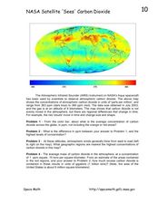
In this atmospheric carbon dioxide activity, students observe a map showing the concentrations of atmospheric carbon dioxide taken by the Atmospheric Infrared Sounder instrument. Students solve 4 problems using the map. They determine...
Curated OER
Diversity
Students work in groups to research and prepare an oral report about a region. In this regions lesson, students find out about the geography, population, state capitals, and landmarks. Students assign attributes to the people based on...
Curated OER
Lewis and Clark and Native Americans, Part II
Students research the Native Americans living in the regions explored by Lewis and Clark. They identify the modern-day names of sites claimed by the Lakota Indians, and create a poster of the original Native American names.


