National Wildlife Federation
An Energy Mix: Renewable and Nonrenewable Resources
What did the windmill say about renewable energy? I'm a BIG fan! Lesson three in the series of 12 has classes discuss potential and kinetic energy and then, in pairs, they complete a web quest over the different types of energy...
CK-12 Foundation
Location on the Earth: Longitude and Latitude
To what degree do learners understand coordinates? Get them some practice in Yosemite National Park in a simple, fun interactive. Pupils explore a map and locate coordinates of popular sights within the park, then answer questions...
CK-12 Foundation
Regular and Irregular Polygons: Polygon States
Colorado would probably object if Wyoming enlarged its borders. Scholars use an interactive map to change the borders of U.S. states to see how angles change. They then answer questions about regular and irregular polygons.
CK-12 Foundation
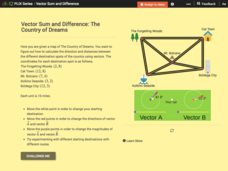
Vector Sum and Difference: The Country of Dreams
Find your way around using vectors. Scholars use an interactive to learn about vector addition. They answer a set of questions about modeling a route on a map using vectors.
Curated OER
How is our place connected to other places?
Second graders conduct a survey, they record their data with the help of maps. They use an aerial photo or Ordnance Survey map, 2nd graders pinpoint specific places and add them to a legend using the drawing tools. Students use...
Curated OER
Water and Land 207
Learners examine maps of different projections, mathematically calculate distortions, and note the advantages and disadvantages of each map. They study the different maps and transfer the map to graph paper.
Curated OER
Media Center Map Skills
Student demonstrates the ability to locate, retrieve, and handle media and equipment by utilizing the library media center floor plan, symbols, and guides. They then use systems of classification to identify, locate, and retrieve materials.
Curated OER
Equator, North Pole, and South Pole
Students identify the Equator, North Pole, and South Pole on the globe. In this map skills lesson, students use a globe marker to locate specific locations on the globe. Students find where they live in relation to the Equator.
Curated OER
Tying it all Together
Students study an article on drugs in their society. In this investigative lesson students create their own concept map.
Curated OER
Dino Detectives
As students examine maps of Utah, 4th graders search for clues about what prehistoric life was like in Utah.
Curated OER
Planning a Railroad
Students use a topographical map to plan a route from Doknner Summit to Truckee, then compare it to the route selected by Theodore Judah.
Curated OER
Pennsylvania Walkers Club
Students participate in an school-wide walking club. Students choose a destination in Pennsylvania they would like to visit. After plotting the best way to get their using a map, the walk each day and record their distance in miles on...
Curated OER
Sum it Up!!
Students work to develop comprehension strategies. Through modeling they discover how to summarize a written passage by deleting unnecessary information and using clustering or concept mapping for the most important items or events. In...
Curated OER
Stranded along the Coast
Students plot stranding sites onto a map using latitude and longitude as well as compass directions with respect to coastal features. They identify several species of marine animals that might become stranded; distinguish their...
Curated OER
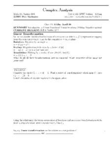
Complex Analysis: Linear Fractional Transformations
For this transformation worksheet, students explore linear transformations and mappings. They map equations on a coordinate plane. This two-page worksheet contains approximately three problems.
Curated OER
Super Summarizers
Students examine the process of summarization by creating an event map. They discuss the process of summarizing text, then silently read an article from "Time For Kids" magazine. Students observe the teacher create a map for the...
Curated OER
Our Country's Geography
Third graders study geography. In this United States landforms lesson, 3rd graders create a map of the U.S. made out of dough. They use various edible treats to mark the country's capital, the plains, the mountains and the rivers &...
Curated OER
Tension Over Slavery
Eighth graders research the events that lead to the US Civil War. They use the Jigsaw technique to report the findings of their research.
Curated OER
Nutrition: How important is rice to the world?
Fourth graders point out places on a map that grow rice around the world. In this rice growing lesson plan, 4th graders read about the importance of rice and use a map to see where it comes from.
Curated OER
Where In the World Are You?
Fourth graders fill in blank copies of the United States Map and then the World Map.
Curated OER
Cities of the World
Students identify the symbol for cities on a political map. In this world map lesson, students identify specific cities on the World Political Map. Students should identify the country in which the city is located. Students discuss the...
Curated OER
Using Non-Text Features
Second graders examine graphs and charts from their local newspaper. As a class, they discuss what the data means and how it relates to the article. In groups, they are shown two sets of graphs or charts and they practice explaining...
Curated OER
Agriculture - It Doesn't Just Happen
Sixth graders examine the role of the US Department of Agriculture. For this United States Agriculture lesson, 6th graders create maps with sites and specialty areas. Students create a presentation on the topic they were given to...
Curated OER
Geotagging in school
Students create a digital photo map of the world. In this digital photo map lesson plan, students pick topics such as the Olympics, natural disasters, or trip planning and create a photo map on the computer.
Other popular searches
- Us Map 13 Colonies
- Us Imperialism Map Activity
- Us Map Skills
- Geography Map Skills Us
- Blank Us Maps
- Northeast Us Map
- Northeast Us Map Skills
- Map of Us
- Us Maps of States
- Us States Map Color
- Us Map Activities
- Us States Map Florida


