Curated OER
Chinese Lion Dance
Young scholars celebrate the Chinese New Year and listen to the story behind the Chinese Lion Dance. In this Chinese New Year lesson, students research the geography and culture of China. Young scholars create puppets, dance...
Curated OER
The Brief American Pageant: Girding for War
Though too short to be an adequate presentation, the solitary map in these slides would be a good visual aid to a lecture about Southern secession before and during the Civil War. The color coded states on the map make a good timeline...
Curated OER
Colonial Society on the Eve of Revolution 1700-1775
Six slides show maps, graphs, and trade routes showing the demographics and economy of the early colonial economy. No text is included in this presentation, it is for supplemental use only.
Curated OER
The Brief American Pageant: America Secedes from the Empire
A good companion to your class on the American Revolution, this slideshow provides a short series of maps that detail major campaigns and battles. Though the information on the slides is not sufficient for an entire lecture, the images...
Curated OER
U.S. Place Names Show Our Diversity
Students study place names for different area in the US and determine why they were named in such a way. They examine maps to look at the religious names, "new" beginning names, and copy cat names. They complete a word search to find...
Curated OER
Rapping Regions in America
Students determine what designates a place as a region. They apply their criteria for a region to the US map. They work in groups to write a rap about their region that describes its organization, type and structure.
Curated OER
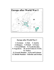
Europe after World War I
In this Europe after World War I map worksheet, students note the 11 regions of the Europe labeled on the map.
Curated OER
You Can Do It, Mr. And Mrs. Mallard!
Learners watch the video "Make Way for Ducklings" by Robert Mc Closkey. They write letters to Mr. and Mrs. Mallard and make a map for the mallards. They talk about the importance of animal habitats.
Curated OER
What A Tombstone Can Tell Us
In this coordinates worksheet, students determine the coordinates to visit a cemetery. Students determine 18 coordinates on this worksheet.
Curated OER
Mapping your watershed
Pupils investigate the importance of watersheds around the world. By visiting resource links, students can locate watersheds and their sources in the USA and Russia and analyze their effects on the surrounding topography. This lesson...
Curated OER
Mapping Lab and Lead Poisoning
Students are introduced to GIS and its uses. They make predictions before viewing the actual lead poisoning cases by location of Dade County. Pupils use actual Miami-Dade County spatial data to explore basic principals. Students
Curated OER
Mapping the National Parks
Students research national parks. In this science lesson, students view a video about the national parks and discuss the environments found within the national parks.
Curated OER
Map the Path in My Father's Dragon
Students listen to Ruth Stiles Gannett's book My Father's Dragon. They predict the outcome of the story. They discuss the events in the story. They sequence the events in the story.
Curated OER
The Distance Between Us and Them: Sea Floor Spreading in the Atlantic Ocean
Young scholars examine how geologists determine rates of sea floor spreading between two tectonic plates. They apply mathematical concepts such as the calculation and use of velocities and conversion from one set of units to another.
Curated OER
The Ozone Between Us
Students investigate how ground level ozone occurs in many areas of the country. They study the ozone problems that are associated with population centers.
Curated OER
Using Google Squared to Compare and Contrast Canada and the US
Sixth graders compare and contrast Canada and the United States. In this geography skills lesson, 6th graders use Google Squared to research information so that they may compare the geography of Canada and the United States.
Curated OER
Colonies and Revolution: Comparing US and Mexican History
Students examine the emergence of the United States and Mexico as independent nations. They compare the colonial history of the two countries and discover the emergence of social classes.
Curated OER
Using Star Charts and Maps
Students study star charts and describe locations of objects. In this scientific models lesson plan students use coordinates and identify characteristics.
Columbus City Schools
Totally Tides
Surf's up, big kahunas! How do surfers know when the big waves will appear? They use science! Over the course of five days, dive in to the inner workings of tidal waves and learn to predict sea levels with the moon as your guide.
Columbus City Schools
It’s Electric!
Shocking! Who knew so many great ideas existed for teaching middle schoolers about electricity? Find them all within this energetic framework. You'll light up at the variety of printable and web-based resources within! After building...
Columbus City Schools
Experiencing Eclipses
Don't be caught in the dark! Young scientists investigate the causes of both solar and lunar eclipses using an interactive to help them understand the development of an eclipse over time. They then research facts and characteristics...
Glynn County School System
Earth's Magnetic Field and the Moon
The surface of the moon has an amazing tale to tell. Learn about the moon's story with a PowerPoint presentation that describes the unique features of the moon's surface as well as explains its movement in relation to Earth.
Curated OER
Basic U.S. Geography
Provide your 11th graders with a basic understanding of U.S. Geography. They label the state, regions, and boundaries found in the contiguous U.S. as well as Hawaii and Alaska. Then, they complete two Internet related activities.
Multieducator
Battle of Gettysburg
On July 1, 1863 the Army of Northern Virginia, under the command of General Robert E. Lee met the Army of the Potomac, under the leadership of Major General George Meade. Considered the turning point of the war, the Battle of Gettysburg...
Other popular searches
- Us Map 13 Colonies
- Us Imperialism Map Activity
- Us Map Skills
- Geography Map Skills Us
- Blank Us Maps
- Northeast Us Map
- Northeast Us Map Skills
- Map of Us
- Us Maps of States
- Us States Map Color
- Us Map Activities
- Us States Map Florida


