Curated OER
The Vietnam War: Causes and US Involvement
Students are introduced to the origins of the Vietnam War, including causes and US involvement. They are given a reading handout over the Vietnam war with questions to answer. Students are shown picture of important people, maps, and...
Curated OER
Map that Habitat
Learners participate in an activity that replicates the creation of sea floor bathymetry by taking a simplified form of soundings in the classroom. They discuss sea floor mapping technologies, sonar, soundings, and remote sensing,...
Curated OER
Map-A-Buddy
Young scholars investigate the concept of tracking and spatial movements of animals in relation to the environment in which they live. They participate in an interactive activity by tracking one another over a pre-defined region, record...
PBS
An Attack on Syria- What Would You Do?
Has United States military intervention in the conflicts of other countries always been warranted? After reviewing a brief background on contemporary US conflicts and reading articles describing the civil war in Syria, your learners...
Curated OER
Map It Out
Explore how illustrations add to a story. Young learners will look at picture books to see how the pictures tell the story. They create illustrations to go with a chosen story, and then flip the activity so they have to write a story to...
Curated OER
Electronic Survey Activity
Fifth graders conduct a class survey and share the results with a class in another state via an electronic bulletin board. This technology-rich lesson is an ideal way to have learners practice communicating with others through the use of...
Curated OER
Through the Forest and Home Again: Maps Help Us Find Our Ways
Students read Little Red Riding Hood, focusing on her path home to Grandma's house. In this language arts and geography lesson, students perform a reader's theater, re-creating the walk home and possible routes that could have been...
Curated OER
Exploring our National Parks
Students utilize maps/Atlases to find key spatial information, locate U.S. National Parks, characterize the geography of a specific region, and create a National Park brochure.
Columbus City Schools
Constructive and Destructive Geologic Processes
Show the class the world as they've never seen it before—from way above! Learners try to unravel the mysteries presented by rich satellite imagery, learn to interpret topographic maps, and study erosion by constructing their very...
Curated OER
Listening Comprehension: Retell Main Events of a Story
Story retell is a very important skill. Little learners use a story map and a previously heard story to walk through the retell and story sequencing process. They complete this activity as a whole class and then on their own.
Curated OER
Should the Ming End the Treasure Voyages?
During the first century of Chinese Ming dynasty (1368-1644), the government sent out a total of seven voyages into the Indian Ocean. Young historians will discuss, explain, role play, and compare the decisions made by rulers during the...
Curated OER
United States Map
Learners describe cities they are familiar with. In this United States Map lesson, students understand how cities are listed on a map. Learners become aware of a map legend and the information in it.
Curated OER
United States Map - Lesson 11
Students explore lakes of the United States. In this geography instructional activity, students identify noteworthy lakes on a map of the United States.
Indian Land Tenure Foundation
Maps and Homelands
You are never too young to learn about maps. To better understand the concept of a homeland, students work together to construct a map of their local area out of paper puzzle pieces. They'll put the maps together and then add details by...
Curated OER
Denali Park Topographic Maps
Learners construct a topographic map of the Denali National Park. They identify different elevations and record historic landmarks in student science journals.
Curated OER
Westward Expansion : Mapping
Fifth graders travel along exploring the expeditions of John F. Fremont. In this Westward expansion lesson, 5th graders gain understanding of the events that shaped the west through the use of maps. Students use mapping skills to...
Curated OER
Drawing Conclusions - Is This a Map of the Underground Railroad?
Students complete activities to study potential maps of the Underground Railroad. For this Underground Railroad lesson, students watch a video about map collector Anne Zorela's Underground Railroad map. Students complete a graphic...
SeaWorld
Animal Migrations
Here is a fabulous set of activities for your young scientists. Each lesson contains map, hands-on, and game activities that will help the class understand why and how animals migrate from one place to another. First they'll examine the...
Constitutional Rights Foundation
Refugees from the Caribbean: Cuban and Haitian “Boat People”
Should refugees fleeing poverty be allowed the same entrance into the United States as those fleeing persecution? High schoolers read about US foreign policy in the late 20th century regarding refugees from Cuba and Haiti, and engage in...
Curated OER
Texas Commemorative Maps: Honoring Our Past
To celebrate Texas, groups plan and create a commemorative map for a topic or theme in Texas history. The richly detailed plan and the approach could easily be adapted to any state. Samples are included.
Smithsonian Institution
Borders with the World: Mexican-American War and U.S. Southern Borderlands
The Mexican-American War created social borders—not just physical ones. Scholars learn about the effects of the Mexican-American War on the people living in the borderlands using text excerpts, maps, and partnered activities. Academics...
Columbus City Schools
What is Up Th-air? — Atmosphere
Air, air, everywhere, but what's in it, and what makes Earth's air so unique and special? Journey through the layers above us to uncover our atmosphere's composition and how it works to make life possible below. Pupils conduct...
Kids Discover
Ancient Egypt by KIDS DISCOVER
Discover Ancient Egypt! Learn about mummification and gods, visit pyramids and temples, examine cliff carvings and paintings, take quizzes and engage in activities. Colorful, interactive, and easy to use, this app is not just for kids!
CK-12 Foundation
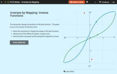
Inverses by Mapping: Inverse Functions
Map your way to successfully understanding inverse functions. Pupils use an interactive map to investigate how changes in the graph of a function affect the graph of its inverse. The results of the activity lead to the conclusion that...


