Curated OER
N is for Natural State
For any pupils who live in the state of Arkansas, this would be a fabulous educational experience to help them get to know their state better. Through the use of activities in literature, art, mathematics, science, social studies, and...
Constitutional Rights Foundation
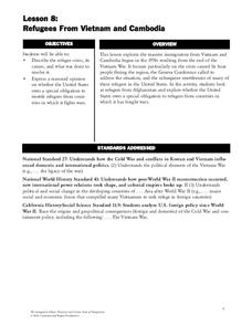
Refugees From Vietnam and Cambodia
The United States may have pulled its troops from the Vietnam War in 1973, but the conflict was far from over for the citizens living in Asia at the time. An informative resource lets learners know about the wave of over 220,000...
Curated OER
United States Map - Lesson 11
Students explore lakes of the United States. In this geography instructional activity, students identify noteworthy lakes on a map of the United States.
New York State Education Department
US History and Government Examination: August 2010
Geography has played a complex role in America history. The Atlantic Ocean has served as a buffer to protect the United States from European Wars, but its proximity to Cuba, however, left it vulnerable to nuclear war during the Cuban...
Curated OER
USA Postal Abbreviations Map
In this United States political map worksheet, students examine the postal abbreviations of each of the states.
Curated OER
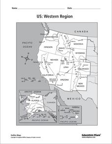
US: Western Region Map
In this United States Western Region worksheet, students examine the state boundaries and landforms found in this region. The map also highlights each of the state capitals.
Curated OER
US Energy Geography
The maps display the statistics for energy consumption and power production, state by state. They are tremendous visual aids for your natural resources unit. Consider having your class compare energy consumption versus production, or...
Curated OER
Places in Arkansas: A Tour of Our Unique State
A great lesson focuses on important cultural and historical places in the state of Arkansas. Learners are introduced to six important places in Arkansas, then create a report on a place in Arkansas. Some excellent photographs, resource...
Curated OER
Blank Jeopardy
Games are a great way to motivate learners to internalize information.. Using this PowerPoint which is in a Jeopardy format, learners can review map skills and facts about the Civil War, famous places, and our government. This is a handy...
Curated OER
Illinois State Map
In this Illinois geography worksheet, students color and label a map of Illinois. Students study the location of the capital and where Illinois is situated in the United States. There is a black line map of the state with a grey US map...
Curated OER
South US Region Map
In this United States regional outline map, students examine the state boundaries of the states in the Southern Region. Capital cities are denoted with stars.
Curated OER
Soil: Food Mapping
Learners examine the concept of food mapping . In this agriculture instructional activity, students explore food and agriculture systems in the United States in the past and today. Learners complete food mapping activities.
Curated OER
Mapping Perceptions
Students create and read maps. In this map skills lesson, students draw a map of their neighborhood, then use skills acquired during map-making to interpret a classmates map and a map of the Ming Dynasty.
Curated OER
Texas Commemorative Maps: Honoring Our Past
To celebrate Texas, groups plan and create a commemorative map for a topic or theme in Texas history. The richly detailed plan and the approach could easily be adapted to any state. Samples are included.
Statistics Education Web
The United States of Obesity
Mississippi has both the highest obesity and poverty rate in the US. Does the rest of the data show a correlation between the poverty and obesity rate in a state? Learners tackle this question as they practice their skills of regression....
US Environmental Protection Agency
Mapping Greenhouse Gas Emissions Where You Live
After investigating the US Environmental Protection Agency's climate change website, your environmental studies students discuss greenhouse gas emissions. They use an online interactive tool to look at data from power production...
John F. Kennedy Presidential Library & Museum
Red States/Blue States: Mapping the Presidential Election
Young historians investigate how voting patterns have changed by comparing the outcome of the 1960 election to the outcome of the recent election. A creative final assessment has participants making a news show wherein they provide...
National Woman's History Museum
19th Amendment
As part of a study of the women's suffrage movement and the ratification of the Nineteenth Amendment, young historians examine documents that detail when voting rights were granted to women in various countries and when US states...
Curated OER
Mt. Whitney to Death Valley
This is an intriguing problem that brings together real-world data, technology, and mathematical problem solving. If visibility wasn't an issue, could you see from the highest point in the lower 48 states, Mt. Whitney, to the lowest...
Curated OER
California's Golden History: 1848-1880
Using a variety of online resources, learners study life and society in California during the gold rush. They use a map to identify area where gold was located, explore pre-selected websites, describe mining practices, and create an...
Curated OER
United States Map Quiz
In this online interactive geography quiz worksheet, students respond to 50 identification questions about the shapes of countries shown. Students have 5 minutes to complete the quiz.
Curated OER
States and Capitals - Lesson 4 - U.S. Political Map
For this U.S. state capitals worksheet, students identify the capital cities of the 50 states using the latitude and longitude coordinates provided.
Curated OER
People Change the Landscape
Students examine ways in which humans have brought change to the natural environment. In this ecology and literacy lesson, students listen to the book Island Boy by Barbara Cooney. Students observe and define map-reading vocabulary as...
Curated OER
United States Map- Rivers
Learners learn about rivers. In this maps lesson, students describe rivers and what human activities take place in a river. Learners use a map to locate the rivers in the United States.


