Curated OER
Understanding Geography
Students create a map of their own neighborhood to show the relationships between the geography of the neighborhood and its economy and culture. They view and discuss an introductory video on how geographers study an area then go out...
Curated OER
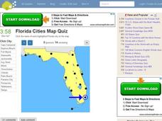
Florida Cities Map Quiz
In this online interactive geography activity, students examine a map of Florida and identify the 12 noted cities on the map using a pull down menu within 3 minutes.
Curated OER
Map Creation
Second graders identify a map, symbol, key, and compass rose. Students create and print a map for teacher evaluation using the computer. Students identify the symbols on their map and orally present them to the class.
Curated OER
Silk Roads Big Map
Students create an oversized map from Europe to East Asia. They include information such as Silk Roads, geographical features, major cities and cultural information on their map.
Curated OER
Will There Be a White Christmas This Year?
Students examine historical weather data, and create map and color key that illustrates the likelihood of a white Christmas in different locations across the United States.
Curated OER
From Home To School
Students locate and use internet maps to trace a route from their home to school. They calculate the distance of the route using the map legend then determine the distance they travel to school and back in a regular school week and over...
Curated OER
Geography of Canada
All about Canada! Learners explore the geography and providences of Canada by watching videos, studying maps and conducting internet research. By the end of this lesson, your class should be able to locate major areas and compare and...
Mathematics Assessment Project
Statistics and Probability
Quickly assess basic understandings of statistics and probability. The resource contains five quick tasks from the probability and statistics domain. The questions range from finding simple conditional probabilities to measures of...
PBS
Accessible Shapes
All the 2-D and 3-D measurement work you need is in one location. Divided into three sections, the geometry lesson plans consist of visualization of three dimensions, classifying geometric figures, and finding surface area and volume....
Mathematics Assessment Project
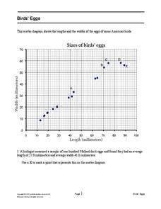
Bird’s Eggs
Are the length and width of birds' eggs related? Young ornathologists use a scatter plot to investigate the relationship between the length and width of eggs for Mallard ducks. They then determine the egg with the greatest...
Curated OER
Agriculture: It Doesn't Just Happen
After reading an informational text on the Agricultural Research Service, learners research the role of the ARS in Oklahoma. Using reputable online sources, they label a map of the state with relevant areas. Researchers focus on one of...
Curated OER
Learn the States and Postal Abbreviations
If you are preparing to cover the 50 states with your class, you don't want to miss this resource. It includes an excellent set of worksheets through which learners practice identifying states from their abbreviations and placing those...
Baylor College
Pre-Assessment Activity: What Do You Know About Microbes?
In an introductory lesson, youngsters take a pre-assessment quiz, get a grasp of a gram of mass, and then estimate the mass of microorganisms that live within a human body. Using Glo Germ™, a material that allows you to simulate the...
Curated OER
Convergence with The Cay: Exploring Geographic Concepts Wrapped in a Story
Here's an awesome unit that uses The Cay as the anchor text. The 16-page packet is loaded with teaching ideas, activities, and suggested adjustments.
Curated OER
Maps, Charts, and Graphs
Students define key geographic terms and track a hurricane on a map. They examine various types of maps and find locations on them,including rivers, cities and mountains.
Curated OER
Mapping a Garden
Second graders recognize the components of a map, particularly the legend, the key, the symbols and the area. They develop their own map of a garden they be planting in their upcoming science lesson plan.
Curated OER
Choropleth Mapping Skills
For this geography worksheet, students identify and describe how to apply choropleth mapping skills. They examine the map given and convert it into a choropleth map through coloring. Then students use those colors to shade in their key...
Curated OER
Geological Maps of the Western Regions
Students study the geological makeup of the West. For this geological maps lesson students creat a map that includes a key and present it to the class.
Curated OER
Reading distance on maps
Eighth graders complete worksheets on reading the distance on maps in miles or kilometers. In this maps lesson plan, 8th graders use a calculator and ruler.
Curated OER
Yo Ho, Yo Ho, A Pirate's Map for Me: An Original Story
Students read Blackbeard and brainstorm their knowledge of maps. In this language arts and geography lesson, students use landmarks on their playground to review north, south, east and west and discuss the compass rose. Students read...
Curated OER
Map Activities
For this geography worksheet, students follow the directions and shade 3 different regions of a UK political map, shade European Union countries on a political map of Europe, match 4 physical feature of Africa to their descriptions, and...
Curated OER
Maps as Models of Earth
Eighth graders use different types of maps to find locations and surface features. In this map-reading instructional activity students use a compass to find direction.
Curated OER
States On A Map
Third graders locate the states of Main and Kansas on a map. In this state location lesson plan, 3rd graders read the book Sarah, Plain and Tall and discuss what states she traveled through.
Curated OER
Geologic Mapping I
Students create a geologic map and cross-section of an area of horizontal sedimentary rocks, exposed in several locations. Map must include a complete key or legend with rock descriptions of the various formations.


