Curated OER
1668 Map of Newark Activity
Eleventh graders read a map for historical information, decipher a map legend and symbols, and expand their knowledge of a historic time.
Curated OER
Map Scale and the Pioneer Journey
Fourth graders use a map, ruler and calculato to determine the distance the pioneers traveled from Nauvoo, Ill. to the Salt Lake Valley.
Curated OER
State to State Scavenger Hunt
In this states worksheet, students utilize the Internet to access one specific website to locate the answers to five fill in the blank statements about the states found on a United States map.
Curated OER
Monarch Butterfly Migration Map
Students examine the migration patterns of the monarch butterfly. They practice using color-coded maps. They create their own maps based on the butterfly's migration. They share their maps wtih the class.
Curated OER
Watershed Investigations
Students explore the components of a watershed and the factors that affect it. They read a topographical map and use geometry to determine the area of a watershed. Students estimate the volume of a body of water and perform runoff...
Curated OER
WORLD GEOGRAPHY
Students identify and analyze map symbols and map grids by completing various worksheets and creating their own map using these skills. Students identify and analyze what latitude and longitude are on a map to play a game of Bingo....
Curated OER
Where Am I?
High schoolers apply map reading skills by locating places through the use of latitude and longitude.
Curated OER
Indianapolis Government
Students read about a girl who takes a trip during the time of the State Capital moving to Indianapolis and then write their own essay about a trip that they took. In this Indianapolis Government lesson plan, students use maps and...
Curated OER
Spatial Connections
Students use maps, scales, and describe locations in order to learn about spatial sense. In this spatial sense lesson plan, students participate in many activities for this spatial sense unit that should last throughout the year.
Curated OER
How Far Away is a Tropial Rainforest?
Students explore how far a rainforest is from their home. In this rainforest lesson students examine how far they live away from the rainforest. Students use the length of their school day to compare how long it will take to travel to...
Curated OER
Geography - Mapping the Holocaust
Eighth graders map the important locations of the Holocaust. In this Holocaust lesson, 8th graders research the location of countries involved in the Holocaust as well as the location of concentration camps. Students mark the locations...
Curated OER
Slavery and the Underground Railroad
Fourth graders study slavery escape routes of the Underground Railroad on maps, read an account of an escape and then write narrative essays about a fictional slave's escape.
Curated OER
Let's Take a Trip!
Sixth graders plan trip for family of four, and choose best travel plan by studying maps, considering different routes, and visiting Web sites to get airline and travel schedules.
Curated OER
Countries of the World
Students identify countries on a world map. In this map skills lesson, students define the word "country" and use post-it notes to locate several countries on a world map.
Curated OER
Then and Now
Students conduct research and use census data to compare different times and places. In this census lesson, students interpret data from charts and graphs, comparing census information from two time periods as well as from two different...
Curated OER
Coral Reef Geography
In this coral reef geography worksheet, students find locations of reefs on a globe or map. There are 10 instructions to follow. There is no map provided--an atlas, globe or map is needed.
Curated OER
Touring Delmarva
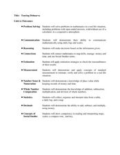
Students plan a trip. In this trip planning activity, students use a map to find where they would like to visit with a pretend family of 4. They get a specific amount of money and time and need to decide where they will stay and...
Curated OER
NASA Satellite 'Sees' Carbon Dioxide
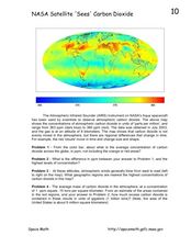
In this atmospheric carbon dioxide worksheet, students observe a map showing the concentrations of atmospheric carbon dioxide taken by the Atmospheric Infrared Sounder instrument. Students solve 4 problems using the map. They determine...
Curated OER
States and Capitals, Mountains and Rivers
Students identify geographical locations in the midwestern United States. For this geography lesson, students identify 12 states and capitals and geographical features in the region by using U.S. maps. Students use blank maps to fill in...
Curated OER
High Five Burger
Fifth graders investigate agricultural sources. In this agricultural lesson, 5th graders read the book Have a Hamburger and See the U.S.A. and record each component of a hamburger. Students use a map of the U.S.A. to locate the...
Curated OER
What Makes a Tropical Rainforest Special?
Students examine the characteristics of the tropical rainforest. Using a map, they locate the rainforests found around the world, continents and the equator. Using the internet, they research the various layers of the rainforest and...
Curated OER
Canadian Immigration
Students discover where Canadian immigrants have come from and their contribution to the country. In this cultural instructional activity, students use a map to indicate the native homes of immigrants, and create a paper chain to...
Curated OER
Radon Gas in the Basement: A Radiation Hazard
In this radon gas worksheet, students read about the harmful effects of radon exposure over time. They use a map that shows radon gas zones to answer 3 questions about exposure to the gas and the amount of radiation that humans get from...
Curated OER
Media Center Map Skills
Student demonstrates the ability to locate, retrieve, and handle media and equipment by utilizing the library media center floor plan, symbols, and guides. They then use systems of classification to identify, locate, and retrieve materials.


