Curated OER
Volcano Vocabulary
In this volcano activity, students match the types of volcanoes and the types of magma and lava with their definitions. They are given the words in boxes and the definitions in a boxes.
Curated OER
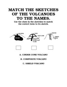
Match the Sketches of the Volcanoes to the Names
In this volcano learning exercise, students are given three pictures of three different types of volcanoes. They are to match the names of each with their pictures.
Curated OER
Types of Scientists
In this science worksheet, students match each type of scientist listed in the left-had column to its correct description found in the right-hand column. There are 34 different scientists to match on the sheet.
Curated OER
Hazards: Fifth Grade Lesson Plans and Activities
After comparing earthquake and volcanic hazards to one another, fifth graders take a closer look at damage associated with a volcanic eruption. They then create a simulation of mudslides due to a volcanic eruption. Using different...
Science Matters
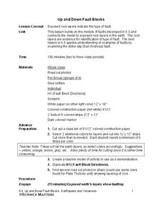
Up and Down Fault Blocks
The Sierra Mountains in Nevada and the Tetons in Wyoming originally formed as fault block mountains. In order to visualize these fault blocks, pupils use construction paper to create layers of earth. They cut the paper models and form...
Curated OER
Plinian Eruptions
In this Plinian eruptions learning exercise, students read about the types of volcanic eruptions and about Gaius Plinius Secundus who the Plinian eruption was named after. Students answer four critical thinking questions about volcanic...
Curated OER
Shake, Rattle, and Roll: Mt. St. Helens - Lesson Plan 2
Students compile information on volcanic activity at Mount St. Helens. In this earth science lesson, students use the information they gathered on Mount St. Helens to answer questions and create charts in Excel. Then students compare...
Brooklyn Children’s Museum
Rocks and Minerals in Our Lives
Young geologists discover the important role that rocks and minerals play in our everyday lives through this series of hands-on activities. Starting off with a lesson that defines the difference between plants, animals, and minerals,...
CK-12 Foundation
Topographic and Geologic Maps: Topographic Maps
Maps are great for helping you get where you're going, but what does that place actually look like? Geology scholars compare and contrast the features of topographical and geologic maps using an interactive lesson. The resource describes...
NOAA
Subduction Zones
Sink into an interactive learning experience about subduction zones! Junior oceanographers examine the earth-shaking and earth-making effects of subduction in the fourth installment in a 13-part series. Hands-on activities include...
Curated OER
Earth's Plate Tectonics
Learners identify the different layers of the Earth. In this earth science lesson, students create a model of the crusts and continents. They explain how plates movement cause earthquakes and volcanoes.
Curated OER
The Gifts of the Nile
Get your class thinking about the geography that shaped the Egyptian landscape and culture. They compare ancient climate zones and geogrpahical fetures, locate evidence of plate tectonics, take and quiz, and write a short essay. The...
Inclement Weather and Its Effect on People
Using http://www.ready.gov/kids/know-the-facts students will read about four different types of emergencies and what to do before, during and after. After reading, students must decide how each could impact the lives of the people,...
Curated OER
Plate Tectonics: Sixth Grade Lesson Plans and Activities
Here is a set of pre-lab, lab, and post-lab lesson plans on plate tectonics. After completing the previous labs on volcanoes and earthquakes, sixth graders use the gained knowledge to explore plate boundaries and the movement of Earth's...
Curated OER
Plate Tectonics: Third Grade Lesson Plans and Activities
Third graders examine plate movements and boundaries with a lab that demonstrates how volcanoes and earthquakes are formed. It presents different types of stresses an object can withstand through a hands-on experiment with clay to...
Curated OER
Plate Tectonics: First Grade Lesson Plans and Activities
A set of first grade geology lessons focuses on plate tectonics and movement of plate boundaries. During the pre-lab, learners experience three types of plate movement through a kinesthetic demonstration. The lab demonstrates stresses...
Curated OER
Plate Tectonics: Second Grade Lesson Plans and Activities
Second graders explore convection currents and how they relate to the movement of tectonic plates. Then, young geologists reconstruct Pangaea with a worksheet and pinpoint plate boundaries on a map using locations of earthquakes and...
Curated OER
The Biggest Plates on Earth
The best part about teaching guides is all the great information you can use to inform your class. They infer what type of boundary exists between two tectonic plates. Then, using given information on earthquakes and volcanism they'll...
NOAA
Plate Tectonics II
Mid-ocean ridges, rift valleys, island arcs, mountain ranges, earthquakes, volcanoes ... there are so many features associated with plate tectonics. The 14th installment of a 23-part NOAA Enrichment in Marine sciences and Oceanography...
Columbus City Schools
Geological Effects of Plate Tectonics
Don't get your classes all shook up about plate movement, instead use a thorough unit that guides learners to an understanding of plate tectonics. The lessons incorporate a study of the types of plate boundaries and their effects on the...
K5 Learning
Landforms
Valleys, mountains, and plateaus are just a few geographic landforms on our Earth. Read about these types and more in a brief landform passage. After reading, learners respond to six short answer comprehension questions.
NOAA
Satellite Communications
How do satellites communicate? What types of satellites orbit Earth? Discover and mimic the way satellites communicate between two points in a hands-on activity that has pupils using mirrors, flashlights, and marbles.
Curated OER
Creating a Disaster
Pupils construct a volcano model. For this earth science lesson, students determine the structure and build of their volcano. They explain the danger of volcanic eruptions.
Curated OER
Ready to Erupt!
Students observe a visual representation of a volcano erupting. They measure and sketch the volcano and discuss how engineers use this information. They discover the type of equipment used to indicate an eruption.


