Curated OER
A World of Information
Students analyze data and statistics about countries around the world. They read graphs and charts, color a world map to illustrate the top ten statistics about the world, and write a paragraph to summarize their information.
World Maps Online
Introduction to the World Map
Students identify the differences between maps and globes. In this map skills instructional activity, students are shown a globe and a map and recognize the differences. Students use post-it notes to locate several locations on the world...
Curated OER
Investigating the Countries of the World
Explore world geography by creating presentations for different countries around the world. Researchers identify many different countries on a globe and select one for which they will create a presentation. They share their research and...
Curated OER
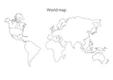
World Map
For this social studies worksheet, learners use the unlabeled world map for any geography activity. The individual countries are not marked with border lines.
Curated OER
Geography and Culture of China
Take out a map, a paper, a ruler, and those coveted colored pencils for a lesson on Chinese culture and geography. This is a multifaceted approach to basic geography skills that incorporate story telling, class discussion, primary source...
California Academy of Science
Tropical Belt
Where in the world is the equator? Explore a world map with your class, coloring in oceans, continents, and rainforests while locating the three major lines of latitude: the equator, Tropic of Cancer, and Tropic of Capricorn. Discuss how...
Population Connection
A Demographically Divided World
Did you know that birth and life rates vary across the world? The resource, the second in a six-part series, discusses just how demographics differ across countries and why it might be the case. Scholars complete worksheets, watch...
Curated OER
Greek Geography
A riddle and a class lecture kick off this lesson on Greek Geography and city features. Learners use a worksheet to answer questions related to what they learned in lecture and complete a homework assignment. Note: This is a lesson...
Curated OER
Lesson Design Archaeology- World Map
Students practice locating positions on the world map. In this map skills instructional activity, students explore the world map and items such as the compass rose, Equator, mountains, cities, etc. The students practice locating...
Curated OER
Geography Experience: Low Vision
The world is a big and beautiful place; but how do you begin to understand it when you have low vision? Here is a great set of ideas focused on transforming any small room into a sensory paradise, themed to incite understanding about...
Curated OER
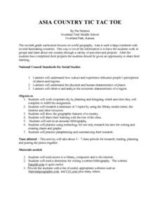
Asia Country: Tic Tac Toe
Enhance your geography class's knowledge of the countries on the Asian continent with this research lesson. Individuals or groups use books, the library, and the Internet to research one Asian country of their choice. Handouts and...
Curated OER
Desert Fever: A Student-Centered Approach to Learning About the Middle East
Explore the exciting and diverse geography, people, history, governments, and economies of the Middle East. Curious minds develop a basic vocabulary of Arabic terms and work with various materials to create an aesthetically pleasing,...
Curated OER
England: Discover a World of Culture and History
England is a very interesting country full of cultural and historical geography. Here is an impressive collection of lessons that will familiarize your students with England's cultural and historical geography. The activities presented...
Curated OER
Waldseemuller's Map: World 1507
Learners investigate the 1507 word map. For this world geography lesson, students examine the details of each section of the map and then draw conclusions about how the people of 1507 understood the world. Learners are evalated on...
Curated OER
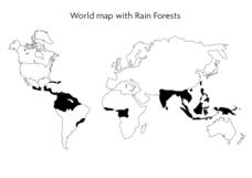
World Map With Rain Forests
In this geography worksheet, students study a map of the world which shows shaded areas indicating where the rain forests are located. There are no labels for countries or continents.
Curated OER
Introduction to the World Globe
Students examine a globe and the world map to see what constitutes the differences. In this world map introductory lesson, students discuss what they see when they view the globe. Students then, look at a world map and compare the...
Curated OER
Geography: Puerto Rico
Take a trip to Puerto Rico! Learners engage in a web quest, identify Puerto Rico on the map, and gather information related to physical features and cultural factors. Their efforts culminate when they design a brochure comparing the...
Curated OER
World Hunger - A Cultural Crisis
Students explore the problem of world hunger and starvation. After a class discussion, students use a map to identify specific areas where populations are starving. In groups, students research reasons for the lack of food. They prepare...
Curated OER
Mapping the News
Students explore cartography. In this map skills and map making lesson, Students work in groups to create wall size world maps including legends, compass roses, latitude and longitude, and physical features. Students collect...
Curated OER
World Geography - Climate Notes
A challenging activity helps young geographers explore the temperatures around the world! They study how the Earth's land temperatures are affected by their proximity to an ocean, as well their latitude and their altitude. A very...
Curated OER
World Map and Globe
Young scholars locate and identify continents and countries. In this world map lesson, students locate and identify one country on each continent.
Curated OER
Oh! The Places I CAN See!
Students explore landmarks around the world. In this world geography and technology lesson, students view world landmarks using a webcam. Students take a virtual field trip during which they zoom in and manipulate three dimensional...
Curated OER
The Desert Alphabet Book
Students explore world geography by researching a science book with their classmates. In this desert identification lesson, students utilize a U.S. map to locate the geographical locations of deserts. Students create an oral report based...
Miami-Dade County Public Schools
Five Themes of Geography Packet
The five themes of geography are perfect for introducing learners to some of the ways that people interact with the world around them. This packet contains 20 full lessons, each focused on topics relating to the five themes of geography,...
Other popular searches
- World War I Map
- Mapping Penny's World
- Map of the World
- World Outline Maps
- Blank Maps of World
- World War 2 Map
- World War 1 Maps
- World War I Outline Map
- Map of World
- World Climate Map
- Blank World Outline Maps
- World Biomes Map


