Curated OER
Africa: Political Map
Students create a political map for Africa. In this country identification lesson, students locate Africa on a globe and discuss some of its major countries and bodies of water. Students complete a political map of Africa and test...
World Maps Online
Introduction to the World Map
Students identify the differences between maps and globes. In this map skills instructional activity, students are shown a globe and a map and recognize the differences. Students use post-it notes to locate several locations on the world...
Curated OER
Introduction to the World Globe
Students examine a globe and the world map to see what constitutes the differences. For this world map introductory lesson, students discuss what they see when they view the globe. Students then, look at a world map and compare the...
Curated OER
Waldseemuller's Map: World 1507
Learners investigate the 1507 word map. In this world geography lesson, students examine the details of each section of the map and then draw conclusions about how the people of 1507 understood the world. Learners are evalated on...
Curated OER
Waldseemüller’s Map: World 1507
Learners take a closer look at historical maps. For this primary source analysis lesson, students examine the first world map produced by Martin Waldseemuller. Learners complete the included map analysis worksheet and then write letters...
Curated OER
Map Skills
Students examine the nations, battlefields, troop movement of the Germans through Belgium and the location of both fronts during World War I by creating a map. They visualize the strength of the Germans early in the war.
Curated OER
Rivers, Maps, and Math
Middle schoolers use maps to locate and label the major rivers of North and South America. Using the internet, they identify forests, grasslands, mountain ranges and other landforms on the continents as well. They compare and contrast...
Curated OER
World Map and Globe
Students locate and identify continents and countries. In this world map lesson, students locate and identify one country on each continent.
Curated OER
Four Corners Mystery: Where In The World Are We?
Students research and describe various locations around the world using five fundamental themes of geography.
Curated OER
Food Detectives
Students investigate the regions in which particular grains are grown. Using the packaging from a variety of foods, grains are identified and the general locations where they are grown are plotted on a map.
Curated OER
Country Capitals
Students locate country capitals on a world map. In this map skills lesson, students review the definition of the word country and discuss what a capital is. Students locate and label capital cities on a world map using a map marker.
Curated OER
Europe Before and after WWI
Eighth graders compare and contrast maps of Europe before and after World War I. In this World War I lesson, 8th graders color and label maps of Europe prior to the war and after it. The historical maps can be accessed online.
Curated OER
Hemispheres & Continents
Students learn in cooperative learning groups to determine how the equator and the Prime Meridian divide the earth into hemispheres and use Venn diagrams. Students will locate and label the hemispheres, continents, and oceans.
Curated OER
Put Me in My Place: Using Alphanumeric Grids to Locate Places
Students practice locating points on a large wall grid and create and label a neighborhood map. In this geography lesson, students spell and discuss places as the teacher places them on the map. They discuss the concept of an...
Curated OER
Parthenon
Ninth graders explore he purposes of the Parthenon. In this World History instructional activity, 9th graders create a complete picture of the Parthenon. Students research one aspect of the structure and report their findings back to...
Curated OER
We Live in an International Community
Learners locate the different countries from which their clothing originates. Using a blank map, they identify and color in those areas.
Curated OER
Hungary: The Landscape
Students work in small groups to create a topographic map of Hungary. The map will include labeled line drawing of the bordering countries. Hungary should be three dimensional, made of salt and flour clay. The mountains, plains and...
Constitutional Rights Foundation
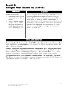
Refugees From Vietnam and Cambodia
The United States may have pulled its troops from the Vietnam War in 1973, but the conflict was far from over for the citizens living in Asia at the time. An informative resource lets learners know about the wave of over 220,000...
Curated OER
The Role Of NATO
Students examine the role of the North Atlantic Treaty Organization (NATO). In this NATO instructional activity, students research the Truman Doctrine, the Marshall Plan, Winston Churchill's "Iron Curtain" speech, and the Berlin airlift...
Curated OER
Louisiana and Canada: Understanding Acadian Cultural connections
Ninth graders investigate why Acadians moved to Lousiana. In this geography lesson, 9th graders research the migration of Acadian to Louisiana and how that influenced the culture. Students analyze a list of cultural and physical...
Curated OER
Overcoming Censorship Through Art
Students create an art piece that expresses their opinions while circumventing hypothetical government restrictions in this lesson on art and government censorship. Emphasis is placed upon historical instances of censorship around the...
Curated OER
Country Capitals
Students define the meaning of country capital. In this country capital lesson, students identify the symbol and find country capitals. Students locate and label capital cities on a map and insert the capital symbol.
Curated OER
Colonization: Africa
Learners analyze maps of Africa. They label physical features, tribal kingdoms, and European settlements, among other topics on the maps. They write reflective paragraphs on their work.
Curated OER
Geographic Context for War
Students explore the geography of Korea. In this Korean War lesson, students examine maps of the country and label landforms, bodies of water, climate, population centers, and neighboring countries to determine the significance of...


