Curated OER
Where in the World War? Mapping the Geography of D-Day
Students examine how to read maps for historical information. They listen to a lecture on the history of D-Day, analyze a historical map of the invasion of Normandy, and answer discussion questions.
University of California
Decolonization
The ripple effect from one small event can impact many others. Young historians research the ripple effect World War II had on decolonization in the second installment of an eight-part series. Through primary and secondary documents as...
Curated OER
Map Studies
Students analyze maps of Europe, and research and discuss current wars in Europe, and compare them to World War I and World War II.
Curated OER
Mapping and Personifying Nations
Eleventh graders analyze the geography, actions, and relationships of countries involved in World War II. They create a map of Europe, Northern Africa, and the Pacific, and analyze and evaluate their self-made map of Europe and the...
Curated OER
World War II Review
Ninth graders review previously presented material on World War II and discover how the world was at that time. They, in groups, participate in map work designed to explain Axis and Allied countries using toy army men.
Curated OER
War Stories
Students watch the film "The Perilous Fight: America's World War II in Color". Using the film, they work together to develop proper interview questions to use while talking to World War II veterns. After the interview, they research...
Curated OER
World War II Veteran Interview Project
Learners learn interview skills by formulating questions and videotaping an interview with a veteran.
Curated OER
The failure of Diplomacy, September-December 1941
Students investigate four main issues of concern between US and Japan prior to US involvement in World War II. In this role play lesson, students will take the role of US and Japanese negotiators trying to find a diplomatic solution to...
Curated OER
Map Skills
Students examine the nations, battlefields, troop movement of the Germans through Belgium and the location of both fronts during World War I by creating a map. They visualize the strength of the Germans early in the war.
Curated OER
Stars and Stripes Forever: Researching Veteran's Day and Historical Events
Sixth graders research Veteran's Day and wars that affected the United States. In this research lesson plan, 6th graders work in small groups to create an oral presentation based on Internet and conventional research. They complete...
Curated OER
A Separate Peace
Tenth graders explore the novel, A Separate Peace by John Knowles. They discuss the events surrounding World War II and the events that were vital to progress during the war. Students locate New Hampshire on a map. They discuss the main...
Curated OER
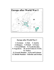
Europe after World War I
In this Europe after World War I map worksheet, young scholars note the 11 regions of the Europe labeled on the map.
Constitutional Rights Foundation
Refugees From Vietnam and Cambodia
The United States may have pulled its troops from the Vietnam War in 1973, but the conflict was far from over for the citizens living in Asia at the time. An informative resource lets learners know about the wave of over 220,000...
Curated OER
First World War Maps
Tenth graders examine the First World War. In this Global History lesson plan, 10th graders analyze various maps of this time. Students construct maps of each front of the war by answering various questions.
Curated OER
Where in the World War? Mapping WWII in the Pacific
Students study the geography of the Pacific theater of World War II. They study maps to examine the geography and features of the land.
Curated OER
WWI for World History Honors
Using a textbook, learners will examine various aspects related to the Triple Alliance of WWI. They complete a series of handouts, engage in a class discussion, and interpret a map showing both the Triple Alliance and the Triple Entente....
Curated OER
Pearl Harbor
Young scholars identify the location of Pearl Harbor and Hawaiian Islands on a map. In this map skills lesson, students use latitude and longitude coordinates to locate various places of importance of the Pearl Harbor attack.
National WWII Museum
“My Dear Little Boys…” Interpreting a letter home from the war
Letters have long been prized by historians as primary sources for what they reveal not only about events but also about the emotional responses of the writers to these events. "My Dear Little Boys," a letter written by Leonard Isacks on...
University of California
Containing Communism Abroad
Learn more about the policy of the United States to contain communism during the Cold War. The fifth installment of an eight-part series looks at primary and secondary materials about a challenging time in history. After analyzing the...
Curated OER
Anne Frank: One of Hundreds of Thousands
Middle schoolers conduct research to put Anne Frank's diary into historical context. They use maps, timelines, essays and websites to examine the early victories of the German army, paying special attention to the Netherlands and...
Curated OER
Europe Before and after WWI
Eighth graders compare and contrast maps of Europe before and after World War I. In this World War I lesson, 8th graders color and label maps of Europe prior to the war and after it. The historical maps can be accessed online.
Curated OER
WWII Website
Tenth graders research a topic related to World War II. They explore the causes and legacy of WWII, the European Theater of Operations, the Pacific Theater of Operations, Diversity in WWII, Women in WWII, and the Homefront. Students...
Curated OER
Revisiting the Somme
Learners consider how the military folly of the Somme during World War I. In this World War I lesson, students visit selected websites to discover information about the Somme, propaganda, and their effects on the war.
Curated OER
Holocaust Unit
Students read a book about World War II and the Holocaust while in small literature circles. They write journal entries and news articles based on the reading.


