University of Oregon
Big Ideas in Beginning Reading
The goal for teachers from the academic content standards is every child to be reading by 3rd grade. This site will help teachers to teach the "big ideas" in reading: phonemic awareness, alphabetic principle, fluency with text,...
University of Oregon
Grambo: This Is a Test of the English Grammar System
Here is a fun way to check your applied grammar knowledge. Determine whether each of the ten sentences is correct or incorrect.
University of Oregon
University of Oregon: Pizzaz!
Come and check out this incredible resource from the University of Oregon. This site features links to creative-writing for poetry and fiction, as well as other teacher resources.
University of Oregon
Mapping History Project : Native American Tribes: 1783
This is a simple map showing where Native American tribes were established in 1783 in the new United States.
University of Oregon
Mapping History Project: Territorial Expansion of the u.s. 1783 1853
Click on the sliding bar and watch how the United States territory grew with the Louisiana Purchase, Florida Acquisitions, Texas Annexation, Oregon Country, and Mexican Cession.
University of Oregon
Mapping History Project: Mexican Cession: Political Boundaries
Click on this map to see the boundaries of Mexico, Texas, and the United States before the Mexican Cession, and then click again to see the land ceded to the U.S. after the Treaty of Guadalupe Hidalgo. Be sure to click to see the key...
University of Oregon
Mapping History Project: Slavery in the American South: 1790 1860
Watch this interactive map to see the spread and concentration of slavery in the South from 1790 to the eve of the Civil War Click on the map to begin. The timeline at the bottom indicates the year. Be sure to access the key. Shockwave...
University of Oregon
Mapping History Project: Missouri Compromise: 1820
Interactive map showing free states and territories and slave states and territories before and after the Missouri Compromise of 1820. Click on the map to choose before or after and the key. Shockwave required.
University of Oregon
Mapping History: African History
Interactive and animated maps and timelines of historical events and time periods in the history of Africa as it went through the colonial rule to reach independence.
University of Oregon
Us Political Thought: View of Jane Addams' Hull House as a Feminist Initiative
Interesting notes on Jane Addams' life, philosophy on Hull House, and social work.
University of Oregon
University of Oregon: Global Climate Animations
Check out this site for global climate animations. "Get a feel for why we have seasonal weather changes or why other regions have different weather than you do."
University of Oregon
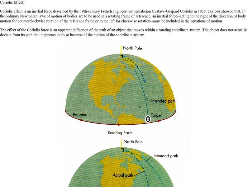
University of Oregon: Coriolis Effect
This site from the University of Oregon provides a great explanation of the Coriolis Effect and then gives several chart type examples to help the understanding of it.
University of Oregon
University of Oregon: Mapping History: Kansas Nebraska Act: 1854
Toggle back and forth on this interactive map to see how the Kansas-Nebraska Act of 1854 completely negated the Missouri Compromise. Click on the map to see where slavery was permitted before 1854 and then after. Be sure to click on the...
University of Oregon
University of Oregon: Mapping History: Jackson's Campaigns in Florida: 1818
This is a map which shows the campaigns Andrew Jackson made into Florida to attack both the Seminoles and Spanish in 1818.
University of Oregon
University of Oregon: Mapping History: Alaska and Hawaii
On this map you can see Alaska and Hawaii in relation to the contiguous United States and read brief text about their purchase/annexation, territorial status, and addition as states.
University of Oregon
University of Oregon: Mapping History: The Spread of Cotton: 1790 1860
An interactive map that shows the growth of cotton production in pre-Civil War South. The timeline at the bottom of the map indicates the year of the production.
University of Oregon
University of Oregon: Mapping History: Slave Crops in the American South: 1860
This very interesting map shows the crops grown by slaves on plantations in pre-Civil War South.
University of Oregon
University of Oregon: Mapping History: Compromise of 1850: Status of Slavery
An interactive map that clearly shows the change in the status of slavery in territories from the Missouri Compromise to the Compromise of 1850. Click on the map to see the status before and after the Compromise of 1850.
University of Oregon
Geo Man's Mineral and Rock Charts
This site contains several charts that can be used for identifying rocks and minerals based on traits such as hardness, luster and color.
University of Oregon
University of Oregon: Photosynthesis
Here at this site from the University of Oregon you can find a general overview of photosynthesis, including background information on photosynthetic organisms, importance of process, overall reaction, and influencing factors.
University of Oregon
Electronic Universe Project: Fossil Fuel Consumption
Information on historical energy consumption in the U.S. and projected figures.
University of Oregon
Streams and Stream Dynamics/evolution of Drainage System
Drainage basis and drainage patterns, in addition to the three stages of stream development(youthful, mature, old age).
University of Oregon
The University of Oregon: Specific Gravity
Specific gravity and density are defined and explained.
University of Oregon
University of Oregon: Experimental Instructions
Visit this summary of friction. Use the interactive JAVA window to run friction simulations.


